
 Česky
Česky Deutsch


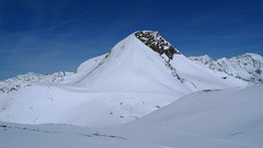
 Stubai Alps Austria photo 01")
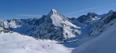
 Stubai Alps Austria photo 02")
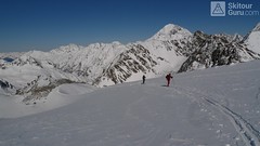
 Stubai Alps Austria photo 03")
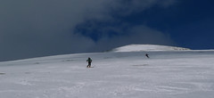
 Stubai Alps Austria photo 04")
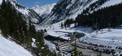


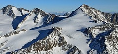
Base station of the Stubaier Gletscherbahn glacier lift. Parking available and access to the tours Ruderhofspitze, Hint. Daunkopf, Zuckerhütl, and Wilder Pfaff.
Tours starting from hut
Ski tours around Hut Stubai - Mutterbergalm (cable car)
-

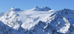
Zuckerhütl (from Mutterbergalm) 3505 m
Stubai - Mutterbergalm (cable car) Stubai Alps Austria
- Length of ascent5 km
- ascent2320 m
- duration7-9,5 h
- Fitness difficulty ♦♦♦♦
- Technical difficulty ♦♦♦◊
Výstup na Zuckerhütl z parkoviště od lanovky je určen jen namakaným borcům, kteří navíc pohrdnou podporou lanovky. Výstup z parkoviště začíná pod lanovkou a zhruba na úrovni Dresdner Hütte pak doleva prudkým svahem do sedla Beiljoch. Po krátkém sjezdu traverzem po moréně k terénnímu zlomu, nad nímž začíná ledovec plný trhlin. V závěru po ledovcovém plató pod vrcholovou homoli cukru. Odtud bez lyží, v mačkách a s cepínem na vrchol. Pro sjezd existují dvě možnosti. Buď po trase výstupu nebo přes sedlo Pfaffenjoch na chatu Hildesheimer Hütte. GPX trasy na Hildesheimer H. si stáhněte u túry Zuckerhütl (from Hildesheimer Hut).

-
Zuckerhütl (from Eisjochferner - cable car) 3505 m
Stubai - Mutterbergalm (cable car) Stubai Alps Austria
- Length of ascent5 km
- ascent960 m
- duration5,5-6,5 h
- Fitness difficulty ♦♦◊◊
- Technical difficulty ♦♦♦◊
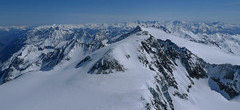
Zuckerhütl je nejvyšší hora Stubaiských Alp. Leží nedaleko ledovcového skiresortu Stubaier Gletscherbahn. Pokud vyjedete lanovkou na nejvyšší bod střediska Eisjochferner a zatočíte po vysednutí ze sedačkové lanovky doleva k restauraci Jochdohle, začnete túru sjezdem z výšky 3150 m po ledovci Gaiskarferner. Ze dna karu (2751 m) do sedla Pfaffenjoch a po plochém ledovci pod vrcholovou pyramidu. Odtud bez lyží, v mačkách a s cepínem na vrchol. Při sjezdu po ledovci Sulzenauferner dávejte velký pozor na četné ledovcové trhliny.
-
Wilder Pfaff (from Mutterbergalm) 3458 m
Stubai - Mutterbergalm (cable car) Stubai Alps Austria
- Length of ascent5 km
- ascent2300 m
- duration7-9 h
- Fitness difficulty ♦♦♦♦
- Technical difficulty ♦♦♦◊
Výstup na Wilder Pfaff je možné spojit do jednoho dlouhého dne se sousedním Zuckerhütlem. Výstup z parkoviště vede pod lanovkou, na úrovni Mittelstation Fernau doleva na sedlo Beiljoch. Pak krátký sjezd a po moréně nad terénní zlom, kde začíná ledovec Sulzenauferner. Navažte se na lono a pokračujte po ledovci s trhlinami až na vrchol, obvykle to jde na lyžích ke křížku. Sousední Zuckerhütl láká ke doublu, pozor na časovou náročnost.
-
Ruderhofspize S (from Stubai Valley) 3473 m
Stubai - Mutterbergalm (cable car) Stubai Alps Austria
- Length of ascent6,5 km
- ascent1770 m
- duration5,5-7 h
- Fitness difficulty ♦♦♦◊
- Technical difficulty ♦♦◊◊
Ruderhofspitze je velkolepá túra širokým jižním svahem, až poslední desítky metrů se musí jít bez lyží. Sjezd po trase výstupu je víceméně příjemného sklonu, většinou mezi 20-25 stupni a hlavně na jarním firnu to je velkolepé svezení.
-
Hinterer Daunkopf E (Stubaital-Mutterbergalm) 3225 m
Stubai - Mutterbergalm (cable car) Stubai Alps Austria
- Length of ascent7 km
- ascent1470 m
- duration5-6,5 h
- Fitness difficulty ♦♦♦◊
- Technical difficulty ♦♦◊◊
Túra na Hinterer Daunkogel je poměrně jednoduchá. Nejprve se stoupá po okraji sjezdovky a pak údolím do sedla Daunjoch. Ze sedla už je to na vrchol kousek. Sjezd po trase výstupu nebo po sjezdovce.
- Country
- Austria
- Montains
- Stubai Alps
- Open (winter)
- 24/7 parking only
- Beds
- 0
- Winterraum
- Shortening of access (cableway, lift, taxi, snowcat...)
- On road B183 through the Stubaital valley
- Luggage transport
- no
- Card Pay
- no
- Shower
- no
- Wifi
- no
- UTM / CH1903 x ("longitude" E/W)
- 32T 663694
- UTM / CH1903 y ("latitude" N/S)
- 5208540
- GPX all tours from the hut
- AUT Stubai_Mutterbergalm_ALL.gpx
- Map
- Stubaier Alpen - Hochstubai, OEAV 31/1 mit Skirouten , 1:25000
- Guides
- Skitourenführer Tirol Schitouren-Atlas ÖSTERREICH WEST Skitourenführer Stubaier Alpen - Panico Alpinverlag
- Phone (hut)
- -
- Phone (valley)
- -
- Cell phone
- -
- Mobile Signal
- yes
- Web
- stubaier-gletscher.com
- info@stubaier-gletscher.com
- Owner of hut
- -
- Stubaier Gletscher
- Avalanche danger
- LWD Tirol
- Weather
- Hildesheimer Hütte - meteoblue.com Stubaier Gletscher - snow-forecast.com Stubaier Wildspitze 3341 - meteoblue.com Zuckerhütl - mountain-forecast.com ORF ZAMG Alpenverein.at
- Snow report
- Stubaier Gletscher - bergfex.at Stubaier Gletscher, onthesnow.com Stubaier Gletscher, snow-forecast.com Stubaier Gletscher, snow.cz
- Webcams
- Stubai Gletscher - all webcams
- Region
- Stubai Tirol
- Public traffic
- Postbus ÖBB Railway
- Skiresort nearby
- Stubaier Gletscher
- Other links
- Austria Tourism
hut Stubai - Mutterbergalm (cable car) - Reviews
There are no reviews in this section yet. Click the Add Review button to add first review.
Best ski tours in mountains Stubai Alps, Austria
-
Schrankogel 3497 m
Amberger Hütte Stubai Alps Austria
- Length of ascent6,5 km
- ascent1300 m
- duration4-6 h
- Fitness difficulty ♦♦♦◊
- Technical difficulty ♦♦♦♦
Schrankogel je impozantní vrchol Stubaiských Alp v oblasti Amberger Hütte. Poměrně snadný nástup na úpatí, odtud na mačkách po místy exponovaném hřebenu na vrchol.
-
Hinterer Daunkopf (N, from Amberger H.) 3225 m
Amberger Hütte Stubai Alps Austria
- Length of ascent7 km
- ascent1100 m
- duration4-5,5 h
- Fitness difficulty ♦♦◊◊
- Technical difficulty ♦♦◊◊
Krásná túra členitým terénem po zajímavé hraně ledovce na vrchol Hinterer Daunkopf. Krásný výhled na sjezdovky střediska Stubaier Gletscher. Pozor na orientaci a hlavně stav ledovce. Sjezd po výstupové linii.
-

Kuhscheibe 3188 m
Amberger Hütte Stubai Alps Austria
- Length of ascent5,5 km
- ascent1050 m
- duration3,5-4,5 h
- Fitness difficulty ♦♦◊◊
- Technical difficulty ♦♦◊◊
Túra na Kuhscheibe patří se středně náročným. Na vrchol se potřeba dolézt v mačkách. Krásný výhled na Ötztálské Alpy včetně střediska Sölden.
Best ski tours in Austria by skitour.guru
-
Preber 2736 m
Tamsweg - Lungau Niedere Tauern Austria
- Length of ascent7 km
- ascent1200 m
- duration4,5-6 h
- Fitness difficulty ♦♦◊◊
- Technical difficulty ♦♦◊◊
Preber je velmi oblíbená vyhlídková túra nad městečkem Tamsweg. Je to jedna z nejširších skialpových sjezdovek v Alpách. Díky jižnímu svahu se lyžuje často po firnu. Z parkoviště od jezera Prebersee postupujete lesem nahoru po sáňkařské cestě. Od chaty Preberhaltehütte už pokračujete širokým svahem pod vrchol. Ke kříži krátký výstup bez lyží. Sjezd po trase výstupu.
-
Similaun N, from Similaunhütte 3606 m
Similaunhütte - Rifugio Similaun Ötztal Alps / Alpi Venoste Austria
- Length of ascent3 km
- ascent650 m
- duration2,5-3,5 h
- Fitness difficulty ♦♦◊◊
- Technical difficulty ♦♦♦◊
Vrchol Similaun od chaty Similaunhütte vede po severovýchodních svazích, převážně po ledovci Niederjochferner. Od chaty na lyžích do skidepotu, a v mačkách s cepínem k vrcholovému kříži.
-

Königstuhl 2336 m
Innerkrems - Mehrlhütte Nockberge Austria
- Length of ascent6,5 km
- ascent840 m
- duration4,5-6 h
- Fitness difficulty ♦♦◊◊
- Technical difficulty ♦♦◊◊
Skialpová túra na Königstuhl je nejlepší trasou v této oblasti, hlavně díky panoramatům na pohoří Nockberge a na Niedere Tauern (Nízké Taury). Snazší výstup vede údolím potoka Krems a výše podél jezera Rosaninsee do sedla Königstuhlscharte. Odtud po plochém západním svahu na vrchol. Sjezd po trase výstupu. Za příznivé lavinové situace je mnohem atraktivnější panoramatická hřebenovka přes Sauereggnock, Vogelsangberg a Seenock. Pozor, místy s exponovanými úseky. Pokud je dobrý sníh, sjeďte z vrcholu Seenock do kotle k jezeru a pokračujte na pásech do sedla a na vrchol. Uvedené údaje platí pro okružní hřebenovou variantu.