
 Česky
Česky Deutsch


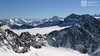


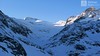
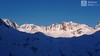
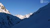


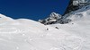

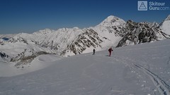
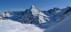
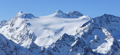
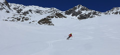
Lyžařská túra na skalnatý vrchol Schrankarkogel nad ledovcem Schwarzenbergferner. Alternativní cíl pro ty, kdo si netroufnou na sousední a impozantní Schrankogel. Orientačně jednoduchá trasa, sjezd po trase výstupu.
Peak
- Country
- Austria
- Montains
- Stubai Alps
- Tags
- Austria Stubai Stubaier Alpen Tirol
- Hut
- Amberger Hütte
- UTM / CH1903 x ("longitude" E/W)
- 32T 659787
- UTM / CH1903 y ("latitude" N/S)
- 5213054
Start point
- Start Point
- Amberger Hütte
- Altitude
- 2135 m
- UTM / CH1903 x ("longitude" E/W)
- 32T 657564
- UTM / CH1903 y ("latitude" N/S)
- 5211937
- village, valley
- Gries (im Sulztal, Ötztal)
Conditions
- Avalanche danger
- LWD Tirol
- Weather
- Amberger Hütte - meteoblue.com Stubaier Gletscher - snow-forecast.com Gries - yr.no Schrankogel 3497m, mountain-forecast.com Ruderhofspitze 3474m, meteoblue.com yr.no - Ruderhofspitze ORF ZAMG Alpenverein.at
- Snow report
- Oetz, snow-forecast.com Gries - Längenfeld, bergfex.at Stubaier Gletscher, onthesnow.com Stubaier Gletscher, snow-forecast.com Stubaier Gletscher
- Webcams
- Franz Senn Hütte Stubai Gletscher Gries
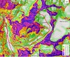
Ski tour map on Schrankarkogel


 bivakovací nouzová chata
  cepín a mačky potřeba
 exponovaný, obtížný terén
 horská chata
 hôtel, penzion
 lanovka, vlek
 lavinové nebezpečí, svah > 30°
 ledovcové trhliny
 lehká túra
 mimořádně obtížná túra
 mírně obtížná túra
 obtížná túra
 parkoviště
 přístup k chatě
 restaurace
 sedlo
sedlo sjezd
sjezd skidepo
 vrchol
 výstup
 začátek ledovce
- bivouac, winter room
- crampons & ice axe necessary
- exposed, difficulty terrain
- mountain hut, refuge
- hotel, pension
- cableway, skilift
- avalanche danger, slope > 30°
- glacier cracks
- little difficult tour
- extremely difficult tour
- rather difficult tour
- difficult tour
- parking
- hut acces
- restaurant
- col, pass, saddle
- descent
- skidepot
- peak, summit
- ascent
- glacier beginning
- biwak, winterraum
- steigeisen & pickel erforderlich
- ausgesetzt, schwierige gelände
- berghütte
- hotel, pension
- seilbahn, skilift
- lawinengefahr, hangneigung > 30°
- gletscherspalten
- wenig schwierige tour
- äusserst schwierige tour
- ziemlich schwierige tour
- schwierige tour
- parkplatz
- zugang zur hütte
- restaurant
- sattel, joch, pass
- abfahrt
- skidepot
- gipfel
- aufsieg
- gletscher anfang
- bivacco, locale invernale
- ramponi & piccozza necessari
- esposto, terreno difficolt?
- rifugio, capanna
- alberghi, pensione
- funivia, seggiovia
- pericolo di valanghe, pendenza > 30°
- crepe glacier
- tour piccolo difficile
- tour estremamente difficile
- tour piuttosto difficile
- escursioni difficili
- parcheggio
- accesso capanna
- ristorante
- col, sella, passo, forcella
- discesa
- sci deposito
- picco, vertice, piz
- salita
- inizio ghiacciaio
- bivouac, local d'hiver
- crampons & piolet nécessaire
- exposée, difficulté du terrain
- cabane de montagne, refuge
- hôtel, pension
- téléphérique, téléski
- danger d'avalanche, pente > 30°
- crevasse du glacier
- peu difficile tour
- extr?mement difficile tournée
- assez difficile tour
- difficile tournée
- parking
- acces cabane
- restaurant
- col, selle
- descente
- skis dépôt
- pic, sommet
- ascension
- début glacier
- < 20°
- 20° - 25°
- 25° - 30°
- 30° - 35°
- 35° - 40°
- > 40°
Current weather conditions in the tour area
Planning of ski tour
- Fitness difficulty
-
- ♦♦◊◊
- Technical difficulty
-
- ♦♦◊◊
- best time for this tour
- januar - april
- Glacier
- Yes
- Map
- Stubaier Alpen - Hochstubai, OEAV 31/1 mit Skirouten , 1:25000
- Guides
- Schitouren-Atlas ÖSTERREICH WEST Skitourenführer Stubaier Alpen - Panico Alpinverlag
About Ski tour
- Time difficulty
- Ascent (height difference)
- 1310 m
- Lenght of ascent
- 6,5 km
- Descent (height difference)
- 1310 m
- Total Lenght of tour
- 13 km
- Total time of the tour
- 4-6 h
- Elevation Range
- 2100 - 3327 m
- Principal Aspect
- SE, W S-south, N-north, W-west, E-east
Download
- GPX (track only)
- Schrankarkogel_Amberger_TRK.gpx best for display on a detailed topographical map (mapy.cz) or in apps for smartphones (Locus, Garmin Connect, etc.)
- GPX (waipoints, track)
- Schrankarkogel_AmbergerH_skitour.gpx great for uploading in GPS device
- KML (with POI)
- Schrankarkogel_AmbergerH_skitour.kml for viewing in the Google Earth 3D map application, which you can install on your PC
tour Schrankarkogel - Reviews
There are no reviews in this section yet. Click the Add Review button to add first review.
Ski tours around Hut Amberger Hütte, in mountains Stubai Alps, Austria
-
Hinterer Daunkopf (N, from Amberger H.) 3225 m
Amberger Hütte Stubai Alps Austria
- Length of ascent7 km
- ascent1100 m
- duration4-5,5 h
- Fitness difficulty ♦♦◊◊
- Technical difficulty ♦♦◊◊
Krásná túra členitým terénem po zajímavé hraně ledovce na vrchol Hinterer Daunkopf. Krásný výhled na sjezdovky střediska Stubaier Gletscher. Pozor na orientaci a hlavně stav ledovce. Sjezd po výstupové linii.

-
Schrankogel 3497 m
Amberger Hütte Stubai Alps Austria
- Length of ascent6,5 km
- ascent1300 m
- duration4-6 h
- Fitness difficulty ♦♦♦◊
- Technical difficulty ♦♦♦♦
Schrankogel je impozantní vrchol Stubaiských Alp v oblasti Amberger Hütte. Poměrně snadný nástup na úpatí, odtud na mačkách po místy exponovaném hřebenu na vrchol.
-

Kuhscheibe 3188 m
Amberger Hütte Stubai Alps Austria
- Length of ascent5,5 km
- ascent1050 m
- duration3,5-4,5 h
- Fitness difficulty ♦♦◊◊
- Technical difficulty ♦♦◊◊
Túra na Kuhscheibe patří se středně náročným. Na vrchol se potřeba dolézt v mačkách. Krásný výhled na Ötztálské Alpy včetně střediska Sölden.
Best ski tours in Stubai Alps by skitour.guru
-

Östliche Seespitze 3416 m
Franz Senn Hütte Stubai Alps Austria
- Length of ascent6,5 km
- ascent1270 m
- duration6-8 h
- Fitness difficulty ♦♦♦◊
- Technical difficulty ♦♦♦◊
Östliche Seespitze (Franz Senn Hütte, Stubaier Alpen) is a glacier tour with a steep passage (30-35°). At the end without skiing along the ridge to the summit.
-
Zuckerhütl (from Eisjochferner - cable car) 3505 m
Stubai - Mutterbergalm (cable car) Stubai Alps Austria
- Length of ascent5 km
- ascent960 m
- duration5,5-6,5 h
- Fitness difficulty ♦♦◊◊
- Technical difficulty ♦♦♦◊
Zuckerhütl je nejvyšší hora Stubaiských Alp. Leží nedaleko ledovcového skiresortu Stubaier Gletscherbahn. Pokud vyjedete lanovkou na nejvyšší bod střediska Eisjochferner a zatočíte po vysednutí ze sedačkové lanovky doleva k restauraci Jochdohle, začnete túru sjezdem z výšky 3150 m po ledovci Gaiskarferner. Ze dna karu (2751 m) do sedla Pfaffenjoch a po plochém ledovci pod vrcholovou pyramidu. Odtud bez lyží, v mačkách a s cepínem na vrchol. Při sjezdu po ledovci Sulzenauferner dávejte velký pozor na četné ledovcové trhliny.
-
Ruderhofspize S (from Stubai Valley) 3473 m
Stubai - Mutterbergalm (cable car) Stubai Alps Austria
- Length of ascent6,5 km
- ascent1770 m
- duration5,5-7 h
- Fitness difficulty ♦♦♦◊
- Technical difficulty ♦♦◊◊
Ruderhofspitze je velkolepá túra širokým jižním svahem, až poslední desítky metrů se musí jít bez lyží. Sjezd po trase výstupu je víceméně příjemného sklonu, většinou mezi 20-25 stupni a hlavně na jarním firnu to je velkolepé svezení.