
 Česky
Česky Deutsch


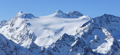
The Amberger Hut in the Stubai Alps is easy to reach from the Ötztal. Many ski tours, in one of the other expositions, can be planned in accordance with the conditions. Excellent ski tours to the summits Kuhscheibe und Hint. Daunkopf or farther Windacher Daunkogel. The highlight of the area Amberger Hut is the spectacular peak Schrankogel. It is also possible traverse to Franz Senn Hut. After the ski tour there are pleasant seats on the sunny terrace.
Tours starting from hut
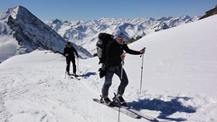
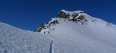
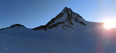
Ski tours around Hut Amberger Hütte
-
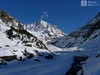
Schrankogel 3497 m
Amberger Hütte Stubai Alps Austria
- Length of ascent6,5 km
- ascent1300 m
- duration4-6 h
- Fitness difficulty ♦♦♦◊
- Technical difficulty ♦♦♦♦
Schrankogel je impozantní vrchol Stubaiských Alp v oblasti Amberger Hütte. Poměrně snadný nástup na úpatí, odtud na mačkách po místy exponovaném hřebenu na vrchol.

-

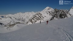
Kuhscheibe 3188 m
Amberger Hütte Stubai Alps Austria
- Length of ascent5,5 km
- ascent1050 m
- duration3,5-4,5 h
- Fitness difficulty ♦♦◊◊
- Technical difficulty ♦♦◊◊
Túra na Kuhscheibe patří se středně náročným. Na vrchol se potřeba dolézt v mačkách. Krásný výhled na Ötztálské Alpy včetně střediska Sölden.
-

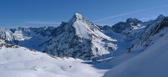
Schrankarkogel 3327 m
Amberger Hütte Stubai Alps Austria
- Length of ascent6,5 km
- ascent1310 m
- duration4-6 h
- Fitness difficulty ♦♦◊◊
- Technical difficulty ♦♦◊◊
Lyžařská túra na skalnatý vrchol Schrankarkogel nad ledovcem Schwarzenbergferner. Alternativní cíl pro ty, kdo si netroufnou na sousední a impozantní Schrankogel. Orientačně jednoduchá trasa, sjezd po trase výstupu.
-
Hinterer Daunkopf (N, from Amberger H.) 3225 m
Amberger Hütte Stubai Alps Austria
- Length of ascent7 km
- ascent1100 m
- duration4-5,5 h
- Fitness difficulty ♦♦◊◊
- Technical difficulty ♦♦◊◊
Krásná túra členitým terénem po zajímavé hraně ledovce na vrchol Hinterer Daunkopf. Krásný výhled na sjezdovky střediska Stubaier Gletscher. Pozor na orientaci a hlavně stav ledovce. Sjezd po výstupové linii.
- Country
- Austria
- Montains
- Stubai Alps
- Open (winter)
- February - early May
- Beds
- 79
- Winterraum
- open, 14 beds
- Shortening of access (cableway, lift, taxi, snowcat...)
- Luggage transport
- yes, from Gries, must be ordered
- Card Pay
- no
- Shower
- yes
- Wifi
- yes
- UTM / CH1903 x ("longitude" E/W)
- 32T 657564
- UTM / CH1903 y ("latitude" N/S)
- 5211937
- GPX access to hut (waipoints, track)
- Amberger-Hut_access_skitour.gpx
- GPX access to hut (track only)
- AmbergerH access_Gries_TRK.gpx
- Map
- Stubaier Alpen - Hochstubai, OEAV 31/1 mit Skirouten , 1:25000
- Guides
- Schitouren-Atlas ÖSTERREICH WEST Skitourenführer Stubaier Alpen - Panico Alpinverlag
- Phone (hut)
- +43 (0)676 9523426
- Phone (valley)
- +43 (0)5254 30354
- Cell phone
- -
- Mobile Signal
- yes
- Web
- amberger-huette.at
- info@ambergerhuette.at
- Owner of hut
- DAV Sektion Amberg
- Ambergerhütte
- Reservation
- phone, e-mail
- Start Point
- Gries im Sulztal
- UTM / CH1903 x ("longitude" E/W)
- 32T 653889
- UTM / CH1903 y ("latitude" N/S)
- 5214895
- Altitude
- 1600 m
- Ascent (height difference)
- 600 m
- Time of Access
- 2-2,5 h
- Shortening lift
- no
- Avalanche danger
- LWD Tirol
- Weather
- Amberger Hütte - meteoblue.com Stubaier Gletscher - snow-forecast.com Gries - yr.no Schrankogel 3497m, mountain-forecast.com Ruderhofspitze 3474m, meteoblue.com yr.no - Ruderhofspitze ORF ZAMG Alpenverein.at
- Snow report
- Oetz, snow-forecast.com Gries - Längenfeld, bergfex.at Stubaier Gletscher, onthesnow.com Stubaier Gletscher, snow-forecast.com Stubaier Gletscher
- Webcams
- Franz Senn Hütte Stubai Gletscher Gries
- Region
- Stubai Tirol Längenfeld Aqua Dome Längenfeld
- Public traffic
- Postbus ÖBB Railway
- Skiresort nearby
- Stubaier Gletscher
- Other links
- Austria Tourism
hut Amberger Hütte - Reviews
There are no reviews in this section yet. Click the Add Review button to add first review.
Best ski tours in mountains Stubai Alps, Austria
-
Zuckerhütl (from Eisjochferner - cable car) 3505 m
Stubai - Mutterbergalm (cable car) Stubai Alps Austria
- Length of ascent5 km
- ascent960 m
- duration5,5-6,5 h
- Fitness difficulty ♦♦◊◊
- Technical difficulty ♦♦♦◊
Zuckerhütl je nejvyšší hora Stubaiských Alp. Leží nedaleko ledovcového skiresortu Stubaier Gletscherbahn. Pokud vyjedete lanovkou na nejvyšší bod střediska Eisjochferner a zatočíte po vysednutí ze sedačkové lanovky doleva k restauraci Jochdohle, začnete túru sjezdem z výšky 3150 m po ledovci Gaiskarferner. Ze dna karu (2751 m) do sedla Pfaffenjoch a po plochém ledovci pod vrcholovou pyramidu. Odtud bez lyží, v mačkách a s cepínem na vrchol. Při sjezdu po ledovci Sulzenauferner dávejte velký pozor na četné ledovcové trhliny.
-

Wilder Pfaff (from Hildesheimer Hütte) 3458 m
Hildesheimer Hütte Stubai Alps Austria
- Length of ascent4,5 km
- ascent700 m
- duration3-4,5 h
- Fitness difficulty ♦♦◊◊
- Technical difficulty ♦♦♦◊
Wilder Pfaff a Zuckerhütl je lákavými cíli z winterraumu chaty Hildesheimer Hütte. Prudký sjezd svahu od chaty na dno karu má velký lavinový potenciál a proto vyžaduje dodržování všech bezpečnostních opatření. Ze dna karu (2750 m) do sedla Pfaffenjoch a po plochém ledovci pod vrcholovou část.Ke kříži je většinou možné vyšlapat na lyžích. Pro sjezd existují dvě možnosti. Buď po trase výstupu zpět na chatu nebo po ledovci Sulzenauferner do údolí Stubaital. Na ledovci dávejte velký pozor na četné ledovcové trhliny.
-
Wildes Hinterbergl 3225 m
Franz Senn Hütte Stubai Alps Austria
- Length of ascent7 km
- ascent1141 m
- duration5-8 h
- Fitness difficulty ♦♦◊◊
- Technical difficulty ♦♦♦◊
Wildes Hinterbergl (Franz Senn Hütte, Stubaier Alpen) is the most attractive ski tour from Franz Senn Hütte. In addition, it offers two variants of the downhill. Great lookout mountain.
Best ski tours in Austria by skitour.guru
-
Schalfkogel West (from M.Busch Hut) 3537 m
Martin-Busch-Hütte Ötztal Alps / Alpi Venoste Austria
- Length of ascent7,5 km
- ascent1200 m
- duration4,5-6 h
- Fitness difficulty ♦♦♦◊
- Technical difficulty ♦♦♦◊
Túra na Schalfkogel od chaty Martin Busch Hütte začíná sjezdem do údolí a pokračuje úzkým koridorem pod ledovcovými morénami východním směrem do sedla Schalfkogeljoch. Zde je skidepot a na vrchol v mačkách a s cepínem. Dolů po trase výstupu.
-

Kreuzspitze 2624 m
Kalkstein - Villgratental Villgratner Berge - Deferegger Alpen Austria
- Length of ascent5,5 km
- ascent955 m
- duration3,5-5 h
- Fitness difficulty ♦♦◊◊
- Technical difficulty ♦♦◊◊
Túra na Kreuzspitze patří k nejoblíbenějším v oblasti Kalksteinu. Široký svah nabízí variabilitu sjezdové trasy. Od mohtného kříže na vrcholu je parádní výhled.
-
Finailspitze North (from Hochjoch Hospiz) 3514 m
Hochjoch Hospiz Ötztal Alps / Alpi Venoste Austria
- Length of ascent7 km
- ascent1390 m
- duration5,5-7 h
- Fitness difficulty ♦♦♦◊
- Technical difficulty ♦♦♦◊
The tour to Fineilspitze begins with a short descent from the Hochjoch Hospiz hut into the valley of the Rofenache stream. Cross the stream and ascend on the right-hand side above the gorge. After the valley widens, continue left up over a moraine onto the glacier. On the glacier, head right of the ridge to a point at 3447 m. Leave the skis there and continue without them, using crampons, over exposed terrain along the ridge to the summit. Descent follows the ascent route.