
 Česky
Česky Deutsch


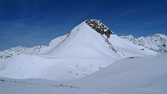
 Stubai Alps Austria photo 01")
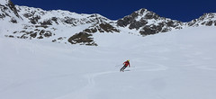
 Stubai Alps Austria photo 02")
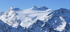
 Stubai Alps Austria panorama 03")
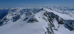
 Stubai Alps Austria panorama 04")
 Stubai Alps Austria photo 05")
 Stubai Alps Austria photo 06")
 Stubai Alps Austria photo 07")
 Stubai Alps Austria photo 08")
 Stubai Alps Austria photo 09")
 Stubai Alps Austria photo 10")
 Stubai Alps Austria photo 11")
 Stubai Alps Austria photo 12")
 Stubai Alps Austria photo 13")
 Stubai Alps Austria photo 14")
 Stubai Alps Austria photo 15")
 Stubai Alps Austria photo 16")
 Stubai Alps Austria photo 17")
 Stubai Alps Austria photo 18")
 Stubai Alps Austria photo 19")
 Stubai Alps Austria photo 20")
 Stubai Alps Austria photo 21")
 Stubai Alps Austria photo 22")
 Stubai Alps Austria photo 23")
 Stubai Alps Austria photo 24")
 Stubai Alps Austria photo 25")
 Stubai Alps Austria photo 26")
 Stubai Alps Austria photo 27")
 Stubai Alps Austria photo 28")


Výstup na Zuckerhütl z parkoviště od lanovky je určen jen namakaným borcům, kteří navíc pohrdnou podporou lanovky. Výstup z parkoviště začíná pod lanovkou a zhruba na úrovni Dresdner Hütte pak doleva prudkým svahem do sedla Beiljoch. Po krátkém sjezdu traverzem po moréně k terénnímu zlomu, nad nímž začíná ledovec plný trhlin. V závěru po ledovcovém plató pod vrcholovou homoli cukru. Odtud bez lyží, v mačkách a s cepínem na vrchol. Pro sjezd existují dvě možnosti. Buď po trase výstupu nebo přes sedlo Pfaffenjoch na chatu Hildesheimer Hütte. GPX trasy na Hildesheimer H. si stáhněte u túry Zuckerhütl (from Hildesheimer Hut).
Peak
- Country
- Austria
- Montains
- Stubai Alps
- Tags
- Austria Stubai Stubaier Alpen Tirol
- Hut
- Stubai - Mutterbergalm (cable car)
- Other Huts
- Hildesheimer Hütte
- UTM / CH1903 x ("longitude" E/W)
- 32T 663844
- UTM / CH1903 y ("latitude" N/S)
- 5203453
Start point
- Start Point
- Mutterbergalm - Stubai, parking
- Altitude
- 3150 m
- UTM / CH1903 x ("longitude" E/W)
- 32T 663694
- UTM / CH1903 y ("latitude" N/S)
- 5208540
- village, valley
- Stubaital
- cableway / lift
- no
Conditions
- Avalanche danger
- LWD Tirol
- Weather
- Hildesheimer Hütte - meteoblue.com Stubaier Gletscher - snow-forecast.com Stubaier Wildspitze 3341 - meteoblue.com Zuckerhütl - mountain-forecast.com ORF ZAMG Alpenverein.at
- Snow report
- Stubaier Gletscher - bergfex.at Stubaier Gletscher, onthesnow.com Stubaier Gletscher, snow-forecast.com Stubaier Gletscher, snow.cz
- Webcams
- Stubai Gletscher - all webcams
Ski tour map on Zuckerhütl (from Mutterbergalm)


 bivakovací nouzová chata
  cepín a mačky potřeba
 exponovaný, obtížný terén
 horská chata
 hôtel, penzion
 lanovka, vlek
 lavinové nebezpečí, svah > 30°
 ledovcové trhliny
 lehká túra
 mimořádně obtížná túra
 mírně obtížná túra
 obtížná túra
 parkoviště
 přístup k chatě
 restaurace
 sedlo
sedlo sjezd
sjezd skidepo
 vrchol
 výstup
 začátek ledovce
- bivouac, winter room
- crampons & ice axe necessary
- exposed, difficulty terrain
- mountain hut, refuge
- hotel, pension
- cableway, skilift
- avalanche danger, slope > 30°
- glacier cracks
- little difficult tour
- extremely difficult tour
- rather difficult tour
- difficult tour
- parking
- hut acces
- restaurant
- col, pass, saddle
- descent
- skidepot
- peak, summit
- ascent
- glacier beginning
- biwak, winterraum
- steigeisen & pickel erforderlich
- ausgesetzt, schwierige gelände
- berghütte
- hotel, pension
- seilbahn, skilift
- lawinengefahr, hangneigung > 30°
- gletscherspalten
- wenig schwierige tour
- äusserst schwierige tour
- ziemlich schwierige tour
- schwierige tour
- parkplatz
- zugang zur hütte
- restaurant
- sattel, joch, pass
- abfahrt
- skidepot
- gipfel
- aufsieg
- gletscher anfang
- bivacco, locale invernale
- ramponi & piccozza necessari
- esposto, terreno difficolt?
- rifugio, capanna
- alberghi, pensione
- funivia, seggiovia
- pericolo di valanghe, pendenza > 30°
- crepe glacier
- tour piccolo difficile
- tour estremamente difficile
- tour piuttosto difficile
- escursioni difficili
- parcheggio
- accesso capanna
- ristorante
- col, sella, passo, forcella
- discesa
- sci deposito
- picco, vertice, piz
- salita
- inizio ghiacciaio
- bivouac, local d'hiver
- crampons & piolet nécessaire
- exposée, difficulté du terrain
- cabane de montagne, refuge
- hôtel, pension
- téléphérique, téléski
- danger d'avalanche, pente > 30°
- crevasse du glacier
- peu difficile tour
- extr?mement difficile tournée
- assez difficile tour
- difficile tournée
- parking
- acces cabane
- restaurant
- col, selle
- descente
- skis dépôt
- pic, sommet
- ascension
- début glacier
- < 20°
- 20° - 25°
- 25° - 30°
- 30° - 35°
- 35° - 40°
- > 40°
Current weather conditions in the tour area
Planning of ski tour
- Fitness difficulty
-
- ♦♦♦♦
- Technical difficulty
-
- ♦♦♦◊
- best time for this tour
- March-May
- Glacier
- Yes
- Map
- Stubaier Alpen - Hochstubai, OEAV 31/1 mit Skirouten , 1:25000
- Guides
- Skitourenführer Tirol Schitouren-Atlas ÖSTERREICH WEST Skitourenführer Stubaier Alpen - Panico Alpinverlag
About Ski tour
- Time difficulty
- Ascent (height difference)
- 2320 m
- Lenght of ascent
- 5 km
- Descent (height difference)
- 2320 m
- Total Lenght of tour
- 15 km
- Total time of the tour
- 7-9,5 h
- Elevation Range
- 1710 - 3505 m
- Principal Aspect
- S, NW, NE S-south, N-north, W-west, E-east
Download
- GPX (track only)
- WildPfaff_Mutterberg_TRK.gpx best for display on a detailed topographical map (mapy.cz) or in apps for smartphones (Locus, Garmin Connect, etc.)
- GPX (waipoints, track)
- Zuckerhutl_Mutterberg_skitour.gpx great for uploading in GPS device
- KML (with POI)
- Zuckerhuetl_Mutterbergalm_skitour.kml for viewing in the Google Earth 3D map application, which you can install on your PC
tour Zuckerhütl (from Mutterbergalm) - Reviews
There are no reviews in this section yet. Click the Add Review button to add first review.
Ski tours around Hut Stubai - Mutterbergalm (cable car), in mountains Stubai Alps, Austria
-
Zuckerhütl (from Eisjochferner - cable car) 3505 m
Stubai - Mutterbergalm (cable car) Stubai Alps Austria
- Length of ascent5 km
- ascent960 m
- duration5,5-6,5 h
- Fitness difficulty ♦♦◊◊
- Technical difficulty ♦♦♦◊
Zuckerhütl je nejvyšší hora Stubaiských Alp. Leží nedaleko ledovcového skiresortu Stubaier Gletscherbahn. Pokud vyjedete lanovkou na nejvyšší bod střediska Eisjochferner a zatočíte po vysednutí ze sedačkové lanovky doleva k restauraci Jochdohle, začnete túru sjezdem z výšky 3150 m po ledovci Gaiskarferner. Ze dna karu (2751 m) do sedla Pfaffenjoch a po plochém ledovci pod vrcholovou pyramidu. Odtud bez lyží, v mačkách a s cepínem na vrchol. Při sjezdu po ledovci Sulzenauferner dávejte velký pozor na četné ledovcové trhliny.

-
Ruderhofspize S (from Stubai Valley) 3473 m
Stubai - Mutterbergalm (cable car) Stubai Alps Austria
- Length of ascent6,5 km
- ascent1770 m
- duration5,5-7 h
- Fitness difficulty ♦♦♦◊
- Technical difficulty ♦♦◊◊
Ruderhofspitze je velkolepá túra širokým jižním svahem, až poslední desítky metrů se musí jít bez lyží. Sjezd po trase výstupu je víceméně příjemného sklonu, většinou mezi 20-25 stupni a hlavně na jarním firnu to je velkolepé svezení.
-
Hinterer Daunkopf E (Stubaital-Mutterbergalm) 3225 m
Stubai - Mutterbergalm (cable car) Stubai Alps Austria
- Length of ascent7 km
- ascent1470 m
- duration5-6,5 h
- Fitness difficulty ♦♦♦◊
- Technical difficulty ♦♦◊◊
Túra na Hinterer Daunkogel je poměrně jednoduchá. Nejprve se stoupá po okraji sjezdovky a pak údolím do sedla Daunjoch. Ze sedla už je to na vrchol kousek. Sjezd po trase výstupu nebo po sjezdovce.
-
Wilder Pfaff (from Mutterbergalm) 3458 m
Stubai - Mutterbergalm (cable car) Stubai Alps Austria
- Length of ascent5 km
- ascent2300 m
- duration7-9 h
- Fitness difficulty ♦♦♦♦
- Technical difficulty ♦♦♦◊
Výstup na Wilder Pfaff je možné spojit do jednoho dlouhého dne se sousedním Zuckerhütlem. Výstup z parkoviště vede pod lanovkou, na úrovni Mittelstation Fernau doleva na sedlo Beiljoch. Pak krátký sjezd a po moréně nad terénní zlom, kde začíná ledovec Sulzenauferner. Navažte se na lono a pokračujte po ledovci s trhlinami až na vrchol, obvykle to jde na lyžích ke křížku. Sousední Zuckerhütl láká ke doublu, pozor na časovou náročnost.
Best ski tours in Stubai Alps by skitour.guru
-

Kuhscheibe 3188 m
Amberger Hütte Stubai Alps Austria
- Length of ascent5,5 km
- ascent1050 m
- duration3,5-4,5 h
- Fitness difficulty ♦♦◊◊
- Technical difficulty ♦♦◊◊
Túra na Kuhscheibe patří se středně náročným. Na vrchol se potřeba dolézt v mačkách. Krásný výhled na Ötztálské Alpy včetně střediska Sölden.
-
Schrankogel 3497 m
Amberger Hütte Stubai Alps Austria
- Length of ascent6,5 km
- ascent1300 m
- duration4-6 h
- Fitness difficulty ♦♦♦◊
- Technical difficulty ♦♦♦♦
Schrankogel je impozantní vrchol Stubaiských Alp v oblasti Amberger Hütte. Poměrně snadný nástup na úpatí, odtud na mačkách po místy exponovaném hřebenu na vrchol.
-
Hinterer Daunkopf (N, from Amberger H.) 3225 m
Amberger Hütte Stubai Alps Austria
- Length of ascent7 km
- ascent1100 m
- duration4-5,5 h
- Fitness difficulty ♦♦◊◊
- Technical difficulty ♦♦◊◊
Krásná túra členitým terénem po zajímavé hraně ledovce na vrchol Hinterer Daunkopf. Krásný výhled na sjezdovky střediska Stubaier Gletscher. Pozor na orientaci a hlavně stav ledovce. Sjezd po výstupové linii.