
 Česky
Česky Deutsch


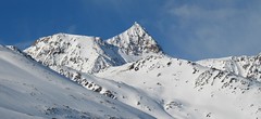


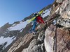
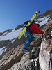
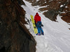


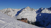


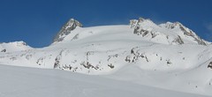
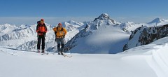
Trasa výstupu je shodná z túrou z chaty Vernagthütte. Při sjezdu odbočte doleva k sedlu Mitterkarjoch. Velký pozor na trhliny na okraji ledovce. Varianta z ledovce doleva vede strmým, vysněženým svahem. Varianta pravá, přes Mitterkarjoch poskytuje při nižší sněhové pokrývce sestup přes feratu obtížnosti B/C. Po vyjetí ze strmých svahů traverzujtedoleva s co nejmenší ztrátou výšky velkým kotlem k chatě Breslauer. Od chaty zpočátku přes strmý svah k horní stanici lanovky ze skiareálu Vent. Po sjezdovkách dolů na parkoviště. Túra jen pro zkušené alpinisty - výborné lyžaře a schopnosti lézt ve skalním terénu!
Peak
- Country
- Austria
- Montains
- Ötztal Alps / Alpi Venoste
- Tags
- Austria Ötztal Ötztaler Alpen Tirol
- Hut
- Vernagthütte
- Other Huts
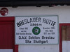
- Breslauer Hütte
- UTM / CH1903 x ("longitude" E/W)
- 32T 642280
- UTM / CH1903 y ("latitude" N/S)
- 5194137
Start point
- Start Point
- Vernagthütte
- Altitude
- 2755 m
- UTM / CH1903 x ("longitude" E/W)
- 32 T 639043
- UTM / CH1903 y ("latitude" N/S)
- 5190513
- village, valley
- Vent
- cableway / lift
- no
Conditions
- Avalanche danger
- lawine.at
- Weather
- Vernagthütte / meteoblue.com Vernagthuette / yr.no Bergwetter Tirol 2 days Vent, snow-forecast.com Hochvernagtspitze 3539 / mountain-forecast.com Wildspitze 3772 / mountain-forecast.com Guslarspitzen 3147 / mountain-forecast.com Fluchtkogel 3500 / mountain-forecast.com Fluchtkogel / meteoblue.com Hint. Brochkogel 3625m / mountain-forecast.com Alpenvereinswetter wetter.at - Austria ZAMG - Austria ORF Wetter
- Snow report
- Vent / bergfex.at Vent / snow-forecast.com Sölden / schneeradar.de Sölden / onthesnow.com
- Webcams
- Vernagthütte Vent Rif. Bella Vista / Schöne Aussicht Hütte Sölden-Rettenbachgletscher
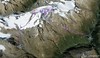
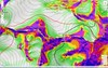
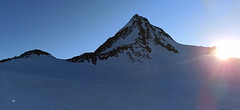
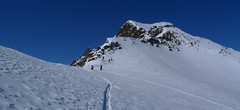
Ski tour map on Wildspitze - Vernagt Hütte to Vent


 bivakovací nouzová chata
  cepín a mačky potřeba
 exponovaný, obtížný terén
 horská chata
 hôtel, penzion
 lanovka, vlek
 lavinové nebezpečí, svah > 30°
 ledovcové trhliny
 lehká túra
 mimořádně obtížná túra
 mírně obtížná túra
 obtížná túra
 parkoviště
 přístup k chatě
 restaurace
 sedlo
sedlo sjezd
sjezd skidepo
 vrchol
 výstup
 začátek ledovce
- bivouac, winter room
- crampons & ice axe necessary
- exposed, difficulty terrain
- mountain hut, refuge
- hotel, pension
- cableway, skilift
- avalanche danger, slope > 30°
- glacier cracks
- little difficult tour
- extremely difficult tour
- rather difficult tour
- difficult tour
- parking
- hut acces
- restaurant
- col, pass, saddle
- descent
- skidepot
- peak, summit
- ascent
- glacier beginning
- biwak, winterraum
- steigeisen & pickel erforderlich
- ausgesetzt, schwierige gelände
- berghütte
- hotel, pension
- seilbahn, skilift
- lawinengefahr, hangneigung > 30°
- gletscherspalten
- wenig schwierige tour
- äusserst schwierige tour
- ziemlich schwierige tour
- schwierige tour
- parkplatz
- zugang zur hütte
- restaurant
- sattel, joch, pass
- abfahrt
- skidepot
- gipfel
- aufsieg
- gletscher anfang
- bivacco, locale invernale
- ramponi & piccozza necessari
- esposto, terreno difficolt?
- rifugio, capanna
- alberghi, pensione
- funivia, seggiovia
- pericolo di valanghe, pendenza > 30°
- crepe glacier
- tour piccolo difficile
- tour estremamente difficile
- tour piuttosto difficile
- escursioni difficili
- parcheggio
- accesso capanna
- ristorante
- col, sella, passo, forcella
- discesa
- sci deposito
- picco, vertice, piz
- salita
- inizio ghiacciaio
- bivouac, local d'hiver
- crampons & piolet nécessaire
- exposée, difficulté du terrain
- cabane de montagne, refuge
- hôtel, pension
- téléphérique, téléski
- danger d'avalanche, pente > 30°
- crevasse du glacier
- peu difficile tour
- extr?mement difficile tournée
- assez difficile tour
- difficile tournée
- parking
- acces cabane
- restaurant
- col, selle
- descente
- skis dépôt
- pic, sommet
- ascension
- début glacier
- < 20°
- 20° - 25°
- 25° - 30°
- 30° - 35°
- 35° - 40°
- > 40°
Current weather conditions in the tour area
Planning of ski tour
- Fitness difficulty
-
- ♦♦♦◊
- Technical difficulty
-
- ♦♦♦♦
- best time for this tour
- march - may
- Glacier
- Yes
- Map
- Wildspitze, OEAV 1:25000, Nr. 30/6 Weisskugel, OEAV 1:25000, Nr. 30/2
- Guides
- Ötztal – Silvretta / Bergverlag Rother, deusch SCHITOUREN-ATLAS ÖSTERREICH WEST / Schall Verlag, deusch Skitourenführer Ötztaler Alpen / Panico, deusch
About Ski tour
- Time difficulty
- Ascent (height difference)
- 1100 m
- Lenght of ascent
- 7,5 km
- Descent (height difference)
- 2000 m
- Total Lenght of tour
- 18 km
- Total time of the tour
- 7-9 h
- Elevation Range
- 2755 - 3770 m
- Principal Aspect
- NW, SW S-south, N-north, W-west, E-east
Download
- GPX (track only)
- Wildspitze_MitterkarJoch_BreslauerHut_TRK.gpx best for display on a detailed topographical map (mapy.cz) or in apps for smartphones (Locus, Garmin Connect, etc.)
- GPX (waipoints, track)
- Wildspitze_VernagtH_MitterkarJ_Vent_skitour.gpx great for uploading in GPS device
- KML (with POI)
- Wildspitze_VernagtHut_BreslauerHut_TRK.kml for viewing in the Google Earth 3D map application, which you can install on your PC
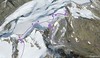
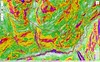
Current avalanche potential on tour - Wildspitze - Vernagt Hütte to Vent

tour Wildspitze - Vernagt Hütte to Vent - Reviews
There are no reviews in this section yet. Click the Add Review button to add first review.
Ski tours around Hut Vernagthütte, in mountains Ötztal Alps / Alpi Venoste, Austria
-

Wildspitze W - Vernagt Hütte 3770 m
Vernagthütte Ötztal Alps / Alpi Venoste Austria
- Length of ascent7,5 km
- ascent1100 m
- duration5,5-7 h
- Fitness difficulty ♦♦♦◊
- Technical difficulty ♦♦♦◊
Výstup na Wildspize, nejvyšší horu Tyrolska je nejjednodušší z horské chaty Vernagt Hütte. Je to náročná, poměrně dlouhá ledovcová túra. Nejobtížnějším místem je výstup do sedla Brochkogeljoch (pozor na lavinu). Většinou je nutné nasadit mačky. Následuje dlouhá ledovcová pláň a pak prudší výstup na závěrečné plató. Na jeho okraji odložte lyže (skidepot) a v mačkách a s cepínem po hřebeni k vrcholovému kříži. Pozor na převěje při větším množství sněhu.

-
Hochvernagtspitze 3539 m
Vernagthütte Ötztal Alps / Alpi Venoste Austria
- Length of ascent5 km
- ascent790 m
- duration4-5,5 h
- Fitness difficulty ♦♦◊◊
- Technical difficulty ♦♦♦◊
Túra z chaty Vernagthütte na Hochvernagtspitze vede zajímavou ledovcovou krajinou. Po překonání prudkého ledovcového zlomu dojdete k východnímu okraji skalnatého hřebene. Odložíte lyže a pomocí maček a cepínu po hřebeni střídavě nahoru a dolů na vrchol. Pozor při nestabilní konzistenci sněhu! Sjezd po trase výstupu.
-

Guslarspitze N - Vernagthütte 3138 m
Vernagthütte Ötztal Alps / Alpi Venoste Austria
- Length of ascent2,5 km
- ascent450 m
- duration1,5-2,5 h
- Fitness difficulty ♦◊◊◊
- Technical difficulty ♦♦◊◊
Túra na Guslarspitze je nejjednodušší v oblasti chaty Vernagthütte. Svah prudší než 3 stupňů je jen kousek pod vrcholem. Přes vrchol vede nejkratší cesta na sousední chatu Hochjoch Hospiz. Tato túra je bez vrcholové pasáže alternativou pro dny se špatným počasím.
-
Fluchtkogel SE, from Vernagthütte 3500 m
Vernagthütte Ötztal Alps / Alpi Venoste Austria
- Length of ascent4 km
- ascent740 m
- duration3-4,5 h
- Fitness difficulty ♦♦♦◊
- Technical difficulty ♦♦◊◊
Túra na Fluchtkogel z Vernagthütte je výletem za krásnými výhledy přes celé Ötztálské Alpy. Jediný prudší úsek je pod sedle Oberes Guslarjoch a ještě v závěrečném svahu na plochý vrchol. Dolů kolem výstupových stop.
Best ski tours in Ötztal Alps / Alpi Venoste by skitour.guru
-

Weisskugel East, from Hochjoch Hospiz 3739 m
Hochjoch Hospiz Ötztal Alps / Alpi Venoste Austria
- Length of ascent11 km
- ascent1550 m
- duration7-10 h
- Fitness difficulty ♦♦♦♦
- Technical difficulty ♦♦♦◊
Skialpinistická túra na Weisskugel je obtížná především svou délkou. Začátek túry se liší podle sněhové situace. Když je málo sněhu, jde se po rampě, víceméně po vrstevnici k ledovci Hintereisferner. Po ledovci mírně nahoru západním směrem. Prudký je až výšvih do sedla Hintereisjoch, odkud se stoupá doprava, severním směrem k vrcholu. Poslední desítky metrů vedou exponovaným terénem, hodně záleží na množství sněhu.
-
Finailspitze North (from Hochjoch Hospiz) 3514 m
Hochjoch Hospiz Ötztal Alps / Alpi Venoste Austria
- Length of ascent7 km
- ascent1390 m
- duration5,5-7 h
- Fitness difficulty ♦♦♦◊
- Technical difficulty ♦♦♦◊
The tour to Fineilspitze begins with a short descent from the Hochjoch Hospiz hut into the valley of the Rofenache stream. Cross the stream and ascend on the right-hand side above the gorge. After the valley widens, continue left up over a moraine onto the glacier. On the glacier, head right of the ridge to a point at 3447 m. Leave the skis there and continue without them, using crampons, over exposed terrain along the ridge to the summit. Descent follows the ascent route.
-
Schalfkogel West (from M.Busch Hut) 3537 m
Martin-Busch-Hütte Ötztal Alps / Alpi Venoste Austria
- Length of ascent7,5 km
- ascent1200 m
- duration4,5-6 h
- Fitness difficulty ♦♦♦◊
- Technical difficulty ♦♦♦◊
Túra na Schalfkogel od chaty Martin Busch Hütte začíná sjezdem do údolí a pokračuje úzkým koridorem pod ledovcovými morénami východním směrem do sedla Schalfkogeljoch. Zde je skidepot a na vrchol v mačkách a s cepínem. Dolů po trase výstupu.