
 Česky
Česky Deutsch


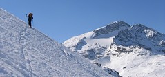


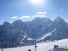


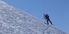


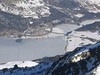


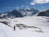


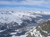

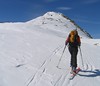

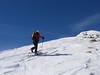


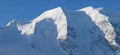
Piz Surlej and Piz San Gian is an interesting ski tour over two neighboring peaks. In the morning you take the cable car to Piz Corvatsch and enjoy the wonderful view of the Albula Alps as well as the lakes Sils and Silvaplana. Follow the ski slope to the Margun Vegl cable car station or to the upper station (2643 m). A logical line to Piz Surlej and further along the ridge to Piz San Gian. And then a spectacular descent to St. Moritz. Warning, some slopes of this ski tour have avalanche potential, especially the descent from the San Gian summit to St. Moritz. This tour is for skiers with good riding technique.
Peak
- Country
- Switzerland
- Montains
- Bernina Alps
- Tags
- Albula Alps Bernina Engadin Graubünden Pontresina Schweiz St. Moritz Switzerland
- Hut
- St. Moritz
- UTM / CH1903 x ("longitude" E/W)
- 784692
- UTM / CH1903 y ("latitude" N/S)
- 147487
Start point
- Start Point
- Corvatsch skiarea - Margun Vegl
- Altitude
- 2403 m
- UTM / CH1903 x ("longitude" E/W)
- 783470
- UTM / CH1903 y ("latitude" N/S)
- 146391
- village, valley
- St. Moritz - Corvatschbahn
- cableway / lift
- yes, from Silvaplana to Corvatsch
Conditions
- Avalanche danger
- slf.ch - Institut für Schnee- und Lawinenforschung
- Weather
- St. Moritz / meteoblue.com St. Moritz / srf.ch St. Moritz / snow-forecast.com Muottas Muragl / mountain-forecast.com Piz Vadret 3199m / mountain-forecast.com Piz Julier 3380m / mountain-forecast.com Piz Surlej 3188m/ mountain-forecast.com Piz Nair 3057m / meteoblue.com Piz Corvatsch 3451m/ mountain-forecast.com St. Moritz / kachelmannwetter.com St. Moritz / wetter.com Switzerland - animation / srf.ch Alpenvereinswetter
- Snow report
- St. Moritz / snow-forecast.com St. Moritz / onthesnow.com St. Moritz - Corvatsch / bergfex.ch St. Moritz / snow.myswitzerland.com
- Webcams
- All webcams around St. Moritz - mountains Muottas Muragl Corvatsch Piz Nair All webcams St. Moritz - city
Ski tour map on Piz Surlej - Piz San Gian


 bivakovací nouzová chata
  cepín a mačky potřeba
 exponovaný, obtížný terén
 horská chata
 hôtel, penzion
 lanovka, vlek
 lavinové nebezpečí, svah > 30°
 ledovcové trhliny
 lehká túra
 mimořádně obtížná túra
 mírně obtížná túra
 obtížná túra
 parkoviště
 přístup k chatě
 restaurace
 sedlo
sedlo sjezd
sjezd skidepo
 vrchol
 výstup
 začátek ledovce
- bivouac, winter room
- crampons & ice axe necessary
- exposed, difficulty terrain
- mountain hut, refuge
- hotel, pension
- cableway, skilift
- avalanche danger, slope > 30°
- glacier cracks
- little difficult tour
- extremely difficult tour
- rather difficult tour
- difficult tour
- parking
- hut acces
- restaurant
- col, pass, saddle
- descent
- skidepot
- peak, summit
- ascent
- glacier beginning
- biwak, winterraum
- steigeisen & pickel erforderlich
- ausgesetzt, schwierige gelände
- berghütte
- hotel, pension
- seilbahn, skilift
- lawinengefahr, hangneigung > 30°
- gletscherspalten
- wenig schwierige tour
- äusserst schwierige tour
- ziemlich schwierige tour
- schwierige tour
- parkplatz
- zugang zur hütte
- restaurant
- sattel, joch, pass
- abfahrt
- skidepot
- gipfel
- aufsieg
- gletscher anfang
- bivacco, locale invernale
- ramponi & piccozza necessari
- esposto, terreno difficolt?
- rifugio, capanna
- alberghi, pensione
- funivia, seggiovia
- pericolo di valanghe, pendenza > 30°
- crepe glacier
- tour piccolo difficile
- tour estremamente difficile
- tour piuttosto difficile
- escursioni difficili
- parcheggio
- accesso capanna
- ristorante
- col, sella, passo, forcella
- discesa
- sci deposito
- picco, vertice, piz
- salita
- inizio ghiacciaio
- bivouac, local d'hiver
- crampons & piolet nécessaire
- exposée, difficulté du terrain
- cabane de montagne, refuge
- hôtel, pension
- téléphérique, téléski
- danger d'avalanche, pente > 30°
- crevasse du glacier
- peu difficile tour
- extr?mement difficile tournée
- assez difficile tour
- difficile tournée
- parking
- acces cabane
- restaurant
- col, selle
- descente
- skis dépôt
- pic, sommet
- ascension
- début glacier
- < 20°
- 20° - 25°
- 25° - 30°
- 30° - 35°
- 35° - 40°
- > 40°
Current weather conditions in the tour area
Planning of ski tour
- Fitness difficulty
-
- ♦♦◊◊
- Technical difficulty
-
- ♦♦♦◊
- best time for this tour
- Februar-April
- Glacier
- No
- Map
- 1257 St. Moritz, Swisstopo 1:25000 S268 Julierpass, Swisstopo 1:50000 2521 St. Moritz-Bernina, Swisstopo 1:25000
- Guides
- Graubünden Süd / SAC-CAS.ch, deutsch Die klassischen Skitouren / SAC-CAS.ch, deutsch Les classiques de randonnée à ski / SAC-CAS.ch, francais Engadin / Rother Skitourenführer, deutsch
About Ski tour
- Time difficulty
- Ascent (height difference)
- 990 m
- Lenght of ascent
- 4 km
- Descent (height difference)
- 1620 m
- Total Lenght of tour
- 9 km
- Total time of the tour
- 4-6 h
- Elevation Range
- 1770 - 3187 m
- Principal Aspect
- W, SW, S, E, N S-south, N-north, W-west, E-east
Download
- GPX (track only)
- PizSurlej_PizSanGian_StMoritz_TRK.gpx best for display on a detailed topographical map (mapy.cz) or in apps for smartphones (Locus, Garmin Connect, etc.)
- GPX (waipoints, track)
- Piz-Surlej_Piz-San-Gian_St-Moritz_skitour.gpx great for uploading in GPS device
- KML (with POI)
- Piz Surlej_San-Gian_Corvatsch_skitour.kml for viewing in the Google Earth 3D map application, which you can install on your PC
Video of tour on Piz Surlej - Piz San Gian
Current avalanche potential on tour - Piz Surlej - Piz San Gian

tour Piz Surlej - Piz San Gian - Reviews
There are no reviews in this section yet. Click the Add Review button to add first review.
Best ski tours in Bernina Alps by skitour.guru
-

Piz Bernina 4048 m
Chamanna Boval / Bovalhütte Bernina Alps Switzerland
- Length of ascent7,5 km
- ascent1695 m
- duration8-10,5 h
- Fitness difficulty ♦♦♦♦
- Technical difficulty ♦♦♦♦
Piz Bernina is the only 4000m peak in the Eastern Alps. The greatest danger are the huge and numerous crevasses on the Morteratsch Glacier and the ridge to the summit. Piz Bernina sets off from Chamanna Boval or Rifugio Marco e Rosa on the plateau below the summit. Bernina is a demanding alpine challenge.

-
Piz Palü 3882 m
Diavolezza Berghaus Bernina Alps Switzerland
- Length of ascent6,5 km
- ascent1180 m
- duration6,5-8,5 h
- Fitness difficulty ♦♦♦◊
- Technical difficulty ♦♦♦◊
The Piz Palü with its characteristic three pillars is probably the most popular "not 4000" in the Alps. The exit from the Berghaus Diavolezza is ideal, it is also possible from the Bovalhütte. The key point for the ascent and descent is the passage of the Labyrinth between the Seraks. Continue over a relatively steep glacier to the ski depot. Then ascent with ice axe and crampons along the exposed summit ridge. The usual goal of ski mountaineers is the eastern summit - 3882 m.
-

Monte Rosso 3088 m
Fornohütte - Capanna del Forno Bernina Alps Switzerland
- Length of ascent4 km
- ascent840 m
- duration4-5,5 h
- Fitness difficulty ♦♦◊◊
- Technical difficulty ♦♦♦◊
Skvělým skialpovým vrcholem uprostřed oblasti je Monte Rosso. Výhodou okruhu je maximalistický krajinářský zážitek. Po výstupu do dvou sedel se otevřou vždy nové výhledy. Od chaty míříme nejprve do sedla Sella del Forno. Koukáme na Berninu a dolů na skiresort Valmalenco. Krásným kotlem po krátkém sjezdu traverujeme a míříme nahoru do druhého sedla – Passo di Val Bona. Po strmějším svahu do místa na skalním hřebenu, kde je skidepot. Odtud v mačkách na vrchol. Na lyžích parádní sjezd jihozápadním svahem na ledovec Forno a zpět nahoru k chatě.