
 Česky
Česky Deutsch


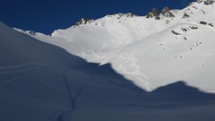
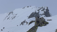
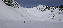
First from the mountain hotel Popradské pleso between mountain lakes Žabie plesa to the exposed section "Dolinka pod Váhou" and then to the mountain hut Chata pod Rysmi. To the saddle "Sedlo Váha" and from there along the exposed ridge to the southeast summit. If you carefully ride into the saddle Váha and then have a nice slope to the valley, pay attention to the rock steps and boulders in the Dolinka. Continue easily along the ascent route to Popradske Pleso.
Peak
- Country
- Slovakia
- Montains
- Vysoké Tatry
- Tags
- Chata pod Rysmi Popradské pleso Slovakia High Tatra Mountains Vysoké Tatry
- Hut
- Popradské pleso - horský hotel
- Other Huts
- Chata pod Rysmi
- UTM / CH1903 x ("longitude" E/W)
- 34U 433505
- UTM / CH1903 y ("latitude" N/S)
- 5447613
Start point
- Start Point
- Popradské pleso - horský hotel
- Altitude
- 1494 m
- UTM / CH1903 x ("longitude" E/W)
- 49°09.29598'
- UTM / CH1903 y ("latitude" N/S)
- 20°04.78176'
- cableway / lift
- no
- Photo by
- Robo Gálfy, www.galfy.sk
Conditions
- Avalanche danger
- Stredisko lavinovej prevencie HZS
- Weather
- Popradské pleso - Meteoblue.com HZS / Mountain Rescue login"user" - meteo station "Vyšné Žabie pleso" HZS / Mountain Rescue login"user" - meteo station "Solisko chata" Rysy 2499 m / mountain-forecast.com Vychodná Vysoká 2574m / mountain-forecast.com Mięguszowiecki Szczyt Wielki 2438 m / mountain-forecast.com Slovensko / shmu.sk Slovensko / meteo.sk Slovensko - meteograms / shmu.sk
- Snow report
- Slovensko / meteo.sk Štrbské pleso / bergfex.com Štrbské pleso / onthesnow.com Štrbské pleso / snow.cz Štrbské pleso / snow-forecast.com
- Webcams
- Popradské pleso Podbanské
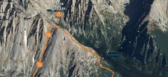
Ski tour map on Rysy, SE vrchol


 bivakovací nouzová chata
  cepín a mačky potřeba
 exponovaný, obtížný terén
 horská chata
 hôtel, penzion
 lanovka, vlek
 lavinové nebezpečí, svah > 30°
 ledovcové trhliny
 lehká túra
 mimořádně obtížná túra
 mírně obtížná túra
 obtížná túra
 parkoviště
 přístup k chatě
 restaurace
 sedlo
sedlo sjezd
sjezd skidepo
 vrchol
 výstup
 začátek ledovce
- bivouac, winter room
- crampons & ice axe necessary
- exposed, difficulty terrain
- mountain hut, refuge
- hotel, pension
- cableway, skilift
- avalanche danger, slope > 30°
- glacier cracks
- little difficult tour
- extremely difficult tour
- rather difficult tour
- difficult tour
- parking
- hut acces
- restaurant
- col, pass, saddle
- descent
- skidepot
- peak, summit
- ascent
- glacier beginning
- biwak, winterraum
- steigeisen & pickel erforderlich
- ausgesetzt, schwierige gelände
- berghütte
- hotel, pension
- seilbahn, skilift
- lawinengefahr, hangneigung > 30°
- gletscherspalten
- wenig schwierige tour
- äusserst schwierige tour
- ziemlich schwierige tour
- schwierige tour
- parkplatz
- zugang zur hütte
- restaurant
- sattel, joch, pass
- abfahrt
- skidepot
- gipfel
- aufsieg
- gletscher anfang
- bivacco, locale invernale
- ramponi & piccozza necessari
- esposto, terreno difficolt?
- rifugio, capanna
- alberghi, pensione
- funivia, seggiovia
- pericolo di valanghe, pendenza > 30°
- crepe glacier
- tour piccolo difficile
- tour estremamente difficile
- tour piuttosto difficile
- escursioni difficili
- parcheggio
- accesso capanna
- ristorante
- col, sella, passo, forcella
- discesa
- sci deposito
- picco, vertice, piz
- salita
- inizio ghiacciaio
- bivouac, local d'hiver
- crampons & piolet nécessaire
- exposée, difficulté du terrain
- cabane de montagne, refuge
- hôtel, pension
- téléphérique, téléski
- danger d'avalanche, pente > 30°
- crevasse du glacier
- peu difficile tour
- extr?mement difficile tournée
- assez difficile tour
- difficile tournée
- parking
- acces cabane
- restaurant
- col, selle
- descente
- skis dépôt
- pic, sommet
- ascension
- début glacier
- < 20°
- 20° - 25°
- 25° - 30°
- 30° - 35°
- 35° - 40°
- > 40°
Current weather conditions in the tour area
Planning of ski tour
- Fitness difficulty
-
- ♦♦♦◊
- Technical difficulty
-
- ♦♦♦◊
- best time for this tour
- Februar-April
- Glacier
- No
- Map
- Vysoké Tatry, 1:25000, Tatraplan, Nr. 2502 Vysoké Tatry 1:50000, VKÚ Harmanec, Nr. 113
- Guides
- Výber lyžiarskych a skialpinistických túr / slovensky
About Ski tour
- Time difficulty
- Ascent (height difference)
- 980 m
- Lenght of ascent
- 4,5 km
- Descent (height difference)
- 980 m
- Total Lenght of tour
- 8,5 km
- Total time of the tour
- 6-8,5 h
- Elevation Range
- 1494 - 2473 m
- Principal Aspect
- S, SW, W S-south, N-north, W-west, E-east
Download
- GPX (track only)
- RYSY from Popradske pleso TRACK.gpx best for display on a detailed topographical map (mapy.cz) or in apps for smartphones (Locus, Garmin Connect, etc.)
- GPX (waipoints, track)
- SVK Tatry ChataPodRysmi_ALL.gpx great for uploading in GPS device
- KML (with POI)
- Rysy_2473m_PopradskePleso_skitour.kml for viewing in the Google Earth 3D map application, which you can install on your PC
tour Rysy, SE vrchol - Reviews
There are no reviews in this section yet. Click the Add Review button to add first review.
Ski tours around Hut Popradské pleso - horský hotel, in mountains Vysoké Tatry, Slovakia
-
Volí chrbát 2321 m
Popradské pleso - horský hotel Vysoké Tatry Slovakia
- Length of ascent3,5 km
- ascent820 m
- duration5,5-7 h
- Fitness difficulty ♦♦◊◊
- Technical difficulty ♦♦◊◊
Favorite ski tour from Popradské Pleso. The ascent begins just as the Chata pod Rysmi. The climb is still going north, the lakes Žabie plesá are on their right side. Continue uphill through the valley between the moraine of Žabie pleso and the ridge of Mengusovský Volovec. Departure follows the ascent route.

-
Koprovský štít 2330 m
Popradské pleso - horský hotel Vysoké Tatry Slovakia
- Length of ascent5 km
- ascent1000 m
- duration6-7 h
- Fitness difficulty ♦♦♦◊
- Technical difficulty ♦♦♦♦
A very challenging ski tour that can be undertaken as a round tour. From the Popradské pleso mountain hotel via the NNW direction through the Mlynická dolina valley to the Malé kozie pleso and Volie plieska lakes. Then a very steep slope of 35-40° to the nameless saddle between peaks Štrbský štít and Hlinská veža. A short steep descent into the Malá Zahrádka area. After a wide slope a comfortable ascent to Vyšné Koprovské sedlo and from there to the left below the NW ridge upwards. Descent to the Vyšné Koprovské sedlo saddle and from there between the rocks along a steep slope (sometimes very exposed, 40-45°) to the Hincové plesa lakes and along the brook Hincový potok through the Mengusovská dolina valley to Popradské pleso.
Best ski tours in Vysoké Tatry by skitour.guru
-
Furkotský štít 2404 m
Chata pod Soliskom - Štrbské Pleso Vysoké Tatry Slovakia
- Length of ascent3,5 km
- ascent650 m
- duration2,5-4 h
- Fitness difficulty ♦♦◊◊
- Technical difficulty ♦♦◊◊
Furkotský štít je oblíbený tatranský vrchol. Nejlépe je dostupný z Chaty pod Soliskom. Výstup vede Furkotskou dolinou přes Nižné a Vyšné Wahlenbergovo pleso. Za jezerem je možné vystupovat dvěma liniemi. Za dobrých podmínek širokým svahem (vlevo) na hřeben a po něm v mačkách na vrchol. Variantou výstupu je trasa přes Bystré sedlo. Tudy obvykle vede i trasa sjezdu. Návrat k chatě vyžaduje na krátký úsek nalepit pásy.
-
Patria 2203 m
Chata pod Soliskom - Štrbské Pleso Vysoké Tatry Slovakia
- Length of ascent5 km
- ascent840 m
- duration3-4,5 h
- Fitness difficulty ♦♦◊◊
- Technical difficulty ♦♦◊◊
Lyžařská túra ze Štrbského plesa na vrchol Patria nabízí možnost okružní trasy, sjezd vede Mlynickou dolinou.
-

Litvorové sedlo 2375 m
Sliezsky Dom - horský hotel Vysoké Tatry Slovakia
- Length of ascent3,5 km
- ascent750 m
- duration4-5,5 h
- Fitness difficulty ♦♦◊◊
- Technical difficulty ♦♦♦◊
A ski tour from the mountain hotel Sliezsky Dom from the valley Velická dolina leads to the lake "Dlhé pleso" and then to the kar"Velický kotol" and further to the mountain lakes "Litvorove plesa". Uphill to the steeper slopes to Sattel Litvorové sedlo. The descent follows on ascent track.