
 Česky
Česky Deutsch


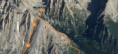
The mountain hotel Popradske pleso on the shore of Popradske pleso has a spacious restaurant and wellness area. It is accessible by car - be careful, you must to reserve a parking place and a drive-in permit in advance. It is forbidden to drive between 9 am-5 pm. From the mountain hotel Popradske pleso you can go to Mengusovska dolina and further to the cottage "Chata pod Rysmi" or to valley Zlomiskova dolina. Popular ski tours from the cottage are Koprovský štít, Volí chrbát, Rysy and Končistá. Through the saddle "Železná brána", there is a route named Tatranska haute route.
Tours starting from hut
Ski tours around Hut Popradské pleso - horský hotel
-
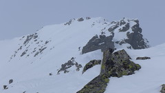
Koprovský štít 2330 m
Popradské pleso - horský hotel Vysoké Tatry Slovakia
- Length of ascent5 km
- ascent1000 m
- duration6-7 h
- Fitness difficulty ♦♦♦◊
- Technical difficulty ♦♦♦♦
A very challenging ski tour that can be undertaken as a round tour. From the Popradské pleso mountain hotel via the NNW direction through the Mlynická dolina valley to the Malé kozie pleso and Volie plieska lakes. Then a very steep slope of 35-40° to the nameless saddle between peaks Štrbský štít and Hlinská veža. A short steep descent into the Malá Zahrádka area. After a wide slope a comfortable ascent to Vyšné Koprovské sedlo and from there to the left below the NW ridge upwards. Descent to the Vyšné Koprovské sedlo saddle and from there between the rocks along a steep slope (sometimes very exposed, 40-45°) to the Hincové plesa lakes and along the brook Hincový potok through the Mengusovská dolina valley to Popradské pleso.

-

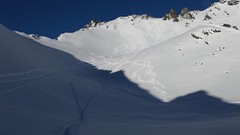
Rysy, SE vrchol 2473 m
Popradské pleso - horský hotel Vysoké Tatry Slovakia
- Length of ascent4,5 km
- ascent980 m
- duration6-8,5 h
- Fitness difficulty ♦♦♦◊
- Technical difficulty ♦♦♦◊
First from the mountain hotel Popradské pleso between mountain lakes Žabie plesa to the exposed section "Dolinka pod Váhou" and then to the mountain hut Chata pod Rysmi. To the saddle "Sedlo Váha" and from there along the exposed ridge to the southeast summit. If you carefully ride into the saddle Váha and then have a nice slope to the valley, pay attention to the rock steps and boulders in the Dolinka. Continue easily along the ascent route to Popradske Pleso.
-
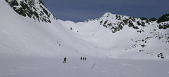
Volí chrbát 2321 m
Popradské pleso - horský hotel Vysoké Tatry Slovakia
- Length of ascent3,5 km
- ascent820 m
- duration5,5-7 h
- Fitness difficulty ♦♦◊◊
- Technical difficulty ♦♦◊◊
Favorite ski tour from Popradské Pleso. The ascent begins just as the Chata pod Rysmi. The climb is still going north, the lakes Žabie plesá are on their right side. Continue uphill through the valley between the moraine of Žabie pleso and the ridge of Mengusovský Volovec. Departure follows the ascent route.
- Country
- Slovakia
- Montains
- Vysoké Tatry
- Open (winter)
- daily
- Beds
- 165
- Winterraum
- no
- Shortening of access (cableway, lift, taxi, snowcat...)
- no, access by car
- Luggage transport
- no
- Card Pay
- yes
- Shower
- yes
- Wifi
- yes
- UTM / CH1903 x ("longitude" E/W)
- 49°09.29598'
- UTM / CH1903 y ("latitude" N/S)
- 20°04.78176'
- GPX access to hut (waipoints, track)
- PopradskePleso-accessTRK.gpx
- GPX all tours from the hut
- SVK Tatry Popradske pleso_ALL.gpx
- Map
- Vysoké Tatry, 1:25000, Tatraplan, Nr. 2502 Vysoké Tatry 1:50000, VKÚ Harmanec, Nr. 113
- Guides
- Výber lyžiarskych a skialpinistických túr / slovensky
- Phone (hut)
- +421 0917 655 446
- Phone (valley)
- -
- Cell phone
- +421 910 948160
- Mobile Signal
- yes
- Web
- popradskepleso.com
- recepcia@popradskepleso.sk
- Owner of hut
- privat
- Horsky Hotel Popradske Pleso
- Reservation
- online form
- Online reservation
- popradskepleso.com
- Start Point
- Popradské pleso - train station / parking
- UTM / CH1903 x ("longitude" E/W)
- 49°07.59594'
- UTM / CH1903 y ("latitude" N/S)
- 20°04.45752'
- Altitude
- 1255 m
- Ascent (height difference)
- 240 m
- Time of Access
- 1-1,5 h
- Shortening lift
- no
- Avalanche danger
- Stredisko lavinovej prevencie HZS
- Weather
- Popradské pleso - Meteoblue.com HZS / Mountain Rescue login"user" - meteo station "Vyšné Žabie pleso" HZS / Mountain Rescue login"user" - meteo station "Solisko chata" Rysy 2499 m / mountain-forecast.com Vychodná Vysoká 2574m / mountain-forecast.com Mięguszowiecki Szczyt Wielki 2438 m / mountain-forecast.com Slovensko / shmu.sk Slovensko / meteo.sk Slovensko - meteograms / shmu.sk
- Snow report
- Slovensko / meteo.sk Štrbské pleso / bergfex.com Štrbské pleso / onthesnow.com Štrbské pleso / snow.cz Štrbské pleso / snow-forecast.com
- Webcams
- Popradské pleso Podbanské
- Region
- travelguide.sk Tatry / e-slovensko.cz VysokeTatry.sk
- Public traffic
- Timetables / Cestovné poriadky
- Skiresort nearby
- Štrbské pleso
- Other links
- Slovakia Tourism slovakia.com
hut Popradské pleso - horský hotel - Reviews
There are no reviews in this section yet. Click the Add Review button to add first review.
Best ski tours in mountains Vysoké Tatry, Slovakia
-
Patria 2203 m
Chata pod Soliskom - Štrbské Pleso Vysoké Tatry Slovakia
- Length of ascent5 km
- ascent840 m
- duration3-4,5 h
- Fitness difficulty ♦♦◊◊
- Technical difficulty ♦♦◊◊
Lyžařská túra ze Štrbského plesa na vrchol Patria nabízí možnost okružní trasy, sjezd vede Mlynickou dolinou.
-
Furkotský štít 2404 m
Chata pod Soliskom - Štrbské Pleso Vysoké Tatry Slovakia
- Length of ascent3,5 km
- ascent650 m
- duration2,5-4 h
- Fitness difficulty ♦♦◊◊
- Technical difficulty ♦♦◊◊
Furkotský štít je oblíbený tatranský vrchol. Nejlépe je dostupný z Chaty pod Soliskom. Výstup vede Furkotskou dolinou přes Nižné a Vyšné Wahlenbergovo pleso. Za jezerem je možné vystupovat dvěma liniemi. Za dobrých podmínek širokým svahem (vlevo) na hřeben a po něm v mačkách na vrchol. Variantou výstupu je trasa přes Bystré sedlo. Tudy obvykle vede i trasa sjezdu. Návrat k chatě vyžaduje na krátký úsek nalepit pásy.
-
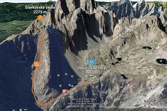
Slavkovské sedlo 2269 m
Zbojnícka chata Vysoké Tatry Slovakia
- Length of ascent1,8 km
- ascent420 m
- duration3-4 h
- Fitness difficulty ♦♦◊◊
- Technical difficulty ♦♦◊◊
The ski tour to the wide saddle Slavkovské sedlo offers a high-quality descent on a slope with a constant incline with an average inclination of 35 degrees. Attention, due to the grassy ground, it is a slope with avalanche potential.
Best ski tours in Slovakia by skitour.guru
-
Baranec 2184 m
Žiarska chata Západné Tatry Slovakia
- Length of ascent2,7 km
- ascent900 m
- duration4-5,5 h
- Fitness difficulty ♦♦♦◊
- Technical difficulty ♦♦♦♦
Baranec is the highest ski tour above the mountain hut Žiarska chata. The most popular variant is Jarný žlab. First, near the hut overcomes the creek. Then follow the ascent through the Jarný žlab, on the steep slope to the ridge. It goes up easier. It is recommended descent trough the Jarny žlab or the neighboring Maďarský žlab. The descent through the Baranecký kotol is very difficult and dangerous.
-
Plačlivo 2125 m
Žiarska chata Západné Tatry Slovakia
- Length of ascent3,5 km
- ascent825 m
- duration2,5-4 h
- Fitness difficulty ♦◊◊◊
- Technical difficulty ♦◊◊◊
Placlivo is a popular, easily accessible peak over the Žiarska dolina valley. The ascent leads towards Žiarske sedlo, over a flat ridge to the summit. One variant is the descent to Placlivy kotol.
-

Spálená 2083 m
Zuberec - Penzion Šindlovec Západné Tatry Slovakia
- Length of ascent6 km
- ascent1050 m
- duration5-6,5 h
- Fitness difficulty ♦♦◊◊
- Technical difficulty ♦♦♦◊
The ascent to the "Spálená" peak leads from the Šindlovec guest house through the eastern part of the "Spálená dolina" valley. The ascent to the summit leads through a wide depression "Spálená mulda". The downhill copied the ascent route and is excellent.