
 Česky
Česky Deutsch


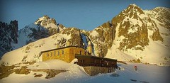


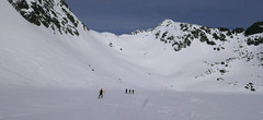
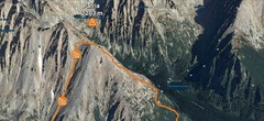
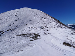
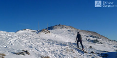
The mountain hut Téryho chata is located in the valleyMalá Studená dolina. Like the Zbojnícka chata, it has optimal access from Hrebienok. Due to the location of the hut, access is very difficult, especially on the steep slope Velky Hang, and there is an avalanche risk for skiers. From Téryho hut, the ski alpinists take ski tours to the saddles - Priečne sedlo, Sedielko, Lomnické sedlo and Baranie sedlo.
Tours starting from hut
Ski tours around Hut Téryho chata
- Country
- Slovakia
- Montains
- Vysoké Tatry
- Open (winter)
- daily
- Beds
- 24
- Winterraum
- no
- Shortening of access (cableway, lift, taxi, snowcat...)
- yes, by train to Hrebienok from Starý Smokovec
- Luggage transport
- no
- Card Pay
- no
- Shower
- no
- Wifi
- no
- UTM / CH1903 x ("longitude" E/W)
- 49°11.40024'
- UTM / CH1903 y ("latitude" N/S)
- 20°11.94846'
- GPX access to hut (waipoints, track)
- TeryhoChata-access_TRACK.gpx
- GPX all tours from the hut
- TATRY Teryho chata_WPT_TRK.gpx
- Map
- Vysoké Tatry, 1:25000, Tatraplan, Nr. 2502 Vysoké Tatry 1:50000, VKÚ Harmanec, Nr. 113
- Guides
- Výber lyžiarskych a skialpinistických túr / slovensky
- Phone (hut)
- +421 949 650315
- Phone (valley)
- -
- Cell phone
- -
- Web
- teryhochata.sk
- teryhochata007@gmail.com
- Owner of hut
- KST (Klub slovenských turistov) a IAMES (horolezecký spolok)
- Téryho chata
- Reservation
- e-mail, phone
- Start Point
- Hrebienok
- UTM / CH1903 x ("longitude" E/W)
- 49°09.49764'
- UTM / CH1903 y ("latitude" N/S)
- 20°13.49010'
- Altitude
- 1272 m
- Ascent (height difference)
- 750 m
- Time of Access
- 2,5-3,5 h
- Shortening lift
- -
- Start Point
- Starý Smokovec
- UTM / CH1903 x ("longitude" E/W)
- 49°08.46558'
- UTM / CH1903 y ("latitude" N/S)
- 20°13.28982'
- Altitude
- 1025 m
- Ascent (height difference)
- - m
- Time of Access
- 3-4 h
- Shortening lift
- Starý Smokovec - Hrebienok
- Avalanche danger
- Stredisko lavinovej prevencie HZS
- Weather
- Zbojnícka chata / Meteoblue.com HZS - počasí v horách HZS / Mountain Rescue login"user" - meteo station "Lomnický štít"a"Ladové pleso" Slavkovský Štít 2452 m / mountain-forecast.com Lomnický štít 2634m / mountain-forecast.com Slovensko / shmu.sk Slovensko / meteo.sk Slovensko - meteograms / shmu.sk
- Snow report
- Slovensko / meteo.sk Štrbské pleso / bergfex.com Smokovec / onthesnow.com Štrbské pleso / snow.cz Starý Smokovec / snow-forecast.com Hrebienok / snow.cz
- Webcams
- Hrebienok Lomnický štít
- Region
- travelguide.sk Tatry / e-slovensko.cz VysokeTatry.sk
- Public traffic
- Timetables / Cestovné poriadky
- Skiresort nearby
- Štrbské pleso Hrebienok
- Other links
- Slovakia Tourism slovakia.com
hut Téryho chata - Reviews
tomas.friedrich 20. 01. 2021
- nocleh ♦◊◊◊
- Staff ♦♦◊◊
- Food ♦♦♦◊
- Overall rating ♦♦◊◊
Best ski tours in mountains Vysoké Tatry, Slovakia
-
Furkotský štít 2404 m
Chata pod Soliskom - Štrbské Pleso Vysoké Tatry Slovakia
- Length of ascent3,5 km
- ascent650 m
- duration2,5-4 h
- Fitness difficulty ♦♦◊◊
- Technical difficulty ♦♦◊◊
Furkotský štít je oblíbený tatranský vrchol. Nejlépe je dostupný z Chaty pod Soliskom. Výstup vede Furkotskou dolinou přes Nižné a Vyšné Wahlenbergovo pleso. Za jezerem je možné vystupovat dvěma liniemi. Za dobrých podmínek širokým svahem (vlevo) na hřeben a po něm v mačkách na vrchol. Variantou výstupu je trasa přes Bystré sedlo. Tudy obvykle vede i trasa sjezdu. Návrat k chatě vyžaduje na krátký úsek nalepit pásy.

-
Patria 2203 m
Chata pod Soliskom - Štrbské Pleso Vysoké Tatry Slovakia
- Length of ascent5 km
- ascent840 m
- duration3-4,5 h
- Fitness difficulty ♦♦◊◊
- Technical difficulty ♦♦◊◊
Lyžařská túra ze Štrbského plesa na vrchol Patria nabízí možnost okružní trasy, sjezd vede Mlynickou dolinou.
-

Bystrá lávka 2314 m
Chata pod Soliskom - Štrbské Pleso Vysoké Tatry Slovakia
- Length of ascent7,5 km
- ascent980 m
- duration4-5,5 h
- Fitness difficulty ♦♦◊◊
- Technical difficulty ♦♦◊◊
Túra do sedla Bystrá lávka vede ze Štrbského plesa Mlynickou dolinou. Trasu lze prodloužit na Furkotský štít a sjet Furkotskou dolinou k Chatě pod Soliskom.
Best ski tours in Slovakia by skitour.guru
-
Baranec 2184 m
Žiarska chata Západné Tatry Slovakia
- Length of ascent2,7 km
- ascent900 m
- duration4-5,5 h
- Fitness difficulty ♦♦♦◊
- Technical difficulty ♦♦♦♦
Baranec is the highest ski tour above the mountain hut Žiarska chata. The most popular variant is Jarný žlab. First, near the hut overcomes the creek. Then follow the ascent through the Jarný žlab, on the steep slope to the ridge. It goes up easier. It is recommended descent trough the Jarny žlab or the neighboring Maďarský žlab. The descent through the Baranecký kotol is very difficult and dangerous.
-
Príslop 2142 m
Žiarska chata Západné Tatry Slovakia
- Length of ascent2,5 km
- ascent855 m
- duration3,5-5,5 h
- Fitness difficulty ♦♦◊◊
- Technical difficulty ♦♦◊◊
The Príslop has a long upper ridge. Ascent begins towards the saddle Jalovecké sedlo. Then pass the waterfall Sarafiový vodopád and then turn right onto the southeast ridge. Follow him to the summit. Prislop offers more downhill routes, mainly SE exposures. As a result, these slopes are often covered with dangerous drift snow in typical NW flows. Take a ski tour to Príslop only in stable snow conditions.
-
Chleb 1645 m
Chata pod Chlebom Malá Fatra Slovakia
- Length of ascent1,5 km
- ascent225 m
- duration1-1,5 h
- Fitness difficulty ♦◊◊◊
- Technical difficulty ♦◊◊◊
Ski tour on Chleb is easy. From Chata pod Chlebom on the way to the Snilovske sedlo saddle. Further along the ridge to the summit. The best descent is usual from the saddle Hromovské sedlo. After almost 300 m of descent, turn right and then to the refuge Chata pod Chlebom.