
 Česky
Česky Deutsch


Zbojnícka chata was built more than 100 years ago in the valley Velká Studená dolina. The access route leads from Hrebienok, which is reachable by train. Most of the route is marked with a bar marking. Attention, the exit leads through several avalanche tracks.
Tours starting from hut
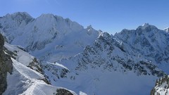
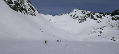
Ski tours around Hut Zbojnícka chata
-

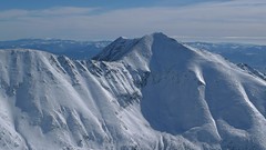
Svišťový štít 2383 m
Zbojnícka chata Vysoké Tatry Slovakia
- Length of ascent2,5 km
- ascent420 m
- duration3-4 h
- Fitness difficulty ♦♦◊◊
- Technical difficulty ♦♦◊◊
Svistovy stit is the only ski accwssible peak in the area of the mountain lodge Zbojnícka chata. The ascent leads through the cauldron Divoký kotol and is possible on SW slope to the eastern summit. One variant is to climb the south ridge. Departure follows the ascent. Attention! The ski tour leads through an area, where according to the current rules of the visitors during a certain period of time, the movement may be prohibited. Check the accessibility of the tour before the ski tour, the decision is up to each individual ...

-

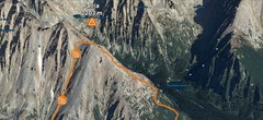
Priečne sedlo SW 2352 m
Zbojnícka chata Vysoké Tatry Slovakia
- Length of ascent3 km
- ascent480 m
- duration2,5-3,5 h
- Fitness difficulty ♦♦◊◊
- Technical difficulty ♦♦◊◊
The saddle Priečne sedlo is one of the ski tour classics of the valley Velka Studena dolina. The High Tatras Haute Route Tatra leads through Priečne sedlo between the mountain huts Zbojnícka chata and Téryho chata.
-

Malý Závrat 2295 m
Zbojnícka chata Vysoké Tatry Slovakia
- Length of ascent1,5 km
- ascent350 m
- duration1,5-2,5 h
- Fitness difficulty ♦♦◊◊
- Technical difficulty ♦♦♦◊
Malý Závrat is a popular, but especially in the upper part of the ski-intensive ski tour (slope to 40°) in the valley Velká Studená dolina.
-
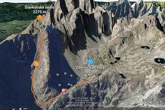
Slavkovské sedlo 2269 m
Zbojnícka chata Vysoké Tatry Slovakia
- Length of ascent1,8 km
- ascent420 m
- duration3-4 h
- Fitness difficulty ♦♦◊◊
- Technical difficulty ♦♦◊◊
The ski tour to the wide saddle Slavkovské sedlo offers a high-quality descent on a slope with a constant incline with an average inclination of 35 degrees. Attention, due to the grassy ground, it is a slope with avalanche potential.
-
Sedlo Prielom 2290 m
Zbojnícka chata Vysoké Tatry Slovakia
- Length of ascent2 km
- ascent330 m
- duration3,5-4,5 h
- Fitness difficulty ♦♦◊◊
- Technical difficulty ♦♦♦◊
The Prielom saddle is a ski tour that leads at the end through the steep and narrow channel. Good complement to the ski tour on Svistovy stit. Attention! The ski tour leads through an area, where according to the current rules of the visitors during a certain period of time, the movement may be prohibited. Check the accessibility of the tour before the ski tour, the decision is up to each individual ...
- Country
- Slovakia
- Montains
- Vysoké Tatry
- Open (winter)
- daily
- Beds
- 16
- Winterraum
- no
- Shortening of access (cableway, lift, taxi, snowcat...)
- yes, by train to Hrebienok from Starý Smokovec
- Luggage transport
- no
- Card Pay
- no
- Shower
- no
- Wifi
- no
- UTM / CH1903 x ("longitude" E/W)
- 49°10.58988'
- UTM / CH1903 y ("latitude" N/S)
- 20°10.03740'
- GPX access to hut (waipoints, track)
- ZbojnickaChata_access.gpx
- GPX all tours from the hut
- ZbojnickaChata_TRK.gpx
- Map
- Vysoké Tatry, 1:25000, Tatraplan, Nr. 2502 Vysoké Tatry 1:50000, VKÚ Harmanec, Nr. 113
- Guides
- Výber lyžiarskych a skialpinistických túr / slovensky
- Phone (hut)
- +421 903 638 000
- Phone (valley)
- -
- Cell phone
- -
- Mobile Signal
- yes
- Web
- zbojnickachata.sk
- rezervacie@zbojnickachata.sk
- Owner of hut
- KST (Klub slovenských turistov) a IAMES (horolezecký spolok)
- Zbojnícka chata
- Reservation
- e-mail, phone
- Start Point
- Hrebienok
- UTM / CH1903 x ("longitude" E/W)
- 49°09.49764
- UTM / CH1903 y ("latitude" N/S)
- 20°13.49010'
- Altitude
- 1272 m
- Ascent (height difference)
- 700 m
- Time of Access
- 3-4 h
- Shortening lift
- -
- Start Point
- Starý Smokovec
- UTM / CH1903 x ("longitude" E/W)
- 49°08.46558'
- UTM / CH1903 y ("latitude" N/S)
- 20°13.28982'
- Altitude
- 1025 m
- Ascent (height difference)
- 950 m
- Time of Access
- 4-5 h
- Shortening lift
- by train from Hrebienok
- Avalanche danger
- Stredisko lavinovej prevencie HZS
- Weather
- Zbojnícka chata / Meteoblue.com HZS - počasí v horách HZS / Mountain Rescue login"user" - meteo station "Lomnický štít"a"Ladové pleso" Slavkovský Štít 2452 m / mountain-forecast.com Lomnický štít 2634m / mountain-forecast.com Slovensko / shmu.sk Slovensko / meteo.sk Slovensko - meteograms / shmu.sk
- Snow report
- Slovensko / meteo.sk Štrbské pleso / bergfex.com Smokovec / onthesnow.com Štrbské pleso / snow.cz Starý Smokovec / snow-forecast.com Hrebienok / snow.cz
- Webcams
- Hrebienok Lomnický štít
- Region
- travelguide.sk Tatry / e-slovensko.cz VysokeTatry.sk
- Public traffic
- Timetables / Cestovné poriadky
- Skiresort nearby
- Štrbské pleso Hrebienok
- Other links
- Slovakia Tourism slovakia.com
hut Zbojnícka chata - Reviews
tomas.friedrich 20. 01. 2021
- Pros když máš james, tak je to levný
- nocleh ♦♦♦♦
- Staff ♦♦◊◊
- Food ♦♦♦◊
- Overall rating ♦◊◊◊
tomas.friedrich 20. 01. 2021
- nocleh ♦♦♦◊
- Staff ♦♦♦◊
- Food ♦♦◊◊
- Overall rating ♦♦♦◊
tomas.friedrich 20. 01. 2021
- nocleh ♦♦♦◊
- Staff ♦♦♦◊
- Food ♦♦◊◊
- Overall rating ♦♦♦◊
Best ski tours in mountains Vysoké Tatry, Slovakia
-
Furkotský štít 2404 m
Chata pod Soliskom - Štrbské Pleso Vysoké Tatry Slovakia
- Length of ascent3,5 km
- ascent650 m
- duration2,5-4 h
- Fitness difficulty ♦♦◊◊
- Technical difficulty ♦♦◊◊
Furkotský štít je oblíbený tatranský vrchol. Nejlépe je dostupný z Chaty pod Soliskom. Výstup vede Furkotskou dolinou přes Nižné a Vyšné Wahlenbergovo pleso. Za jezerem je možné vystupovat dvěma liniemi. Za dobrých podmínek širokým svahem (vlevo) na hřeben a po něm v mačkách na vrchol. Variantou výstupu je trasa přes Bystré sedlo. Tudy obvykle vede i trasa sjezdu. Návrat k chatě vyžaduje na krátký úsek nalepit pásy.
-
Patria 2203 m
Chata pod Soliskom - Štrbské Pleso Vysoké Tatry Slovakia
- Length of ascent5 km
- ascent840 m
- duration3-4,5 h
- Fitness difficulty ♦♦◊◊
- Technical difficulty ♦♦◊◊
Lyžařská túra ze Štrbského plesa na vrchol Patria nabízí možnost okružní trasy, sjezd vede Mlynickou dolinou.
-

Slavkovský štít 2452 m
Sliezsky Dom - horský hotel Vysoké Tatry Slovakia
- Length of ascent5 km
- ascent900 m
- duration6-7,5 h
- Fitness difficulty ♦♦♦◊
- Technical difficulty ♦♦♦◊
The mountain "Slavkovský štit" is a striking summit with southern slopes that starts from the lakes "Kotol Slavkovskych plies". The route leads through the southern ditch to the saddle "Sedlo za Nosom". From there follow the simple ridge to the summit. The descent follows the ascent route.
Best ski tours in Slovakia by skitour.guru
-
Baranec 2184 m
Žiarska chata Západné Tatry Slovakia
- Length of ascent2,7 km
- ascent900 m
- duration4-5,5 h
- Fitness difficulty ♦♦♦◊
- Technical difficulty ♦♦♦♦
Baranec is the highest ski tour above the mountain hut Žiarska chata. The most popular variant is Jarný žlab. First, near the hut overcomes the creek. Then follow the ascent through the Jarný žlab, on the steep slope to the ridge. It goes up easier. It is recommended descent trough the Jarny žlab or the neighboring Maďarský žlab. The descent through the Baranecký kotol is very difficult and dangerous.
-
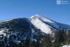
Veľký Kriváň 1709 m
Chata pod Chlebom Malá Fatra Slovakia
- Length of ascent2,7 km
- ascent290 m
- duration2-3 h
- Fitness difficulty ♦◊◊◊
- Technical difficulty ♦♦◊◊
Velký Kriváň is a popular ski tour from Chata pod Chlebom or from the top station of the Vrátna dolina cable car. Via the saddle Snilovske sedlo and further up the ridge to the summit. Descent from the summit to the saddle 1625 m and downhill through Révajová mulda and then to the mountain hut Chata pod Chlebom.
-
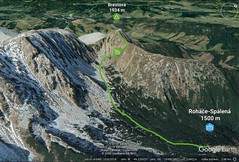
Brestová 1934 m
Zuberec - Penzion Šindlovec Západné Tatry Slovakia
- Length of ascent2,5 km
- ascent430 m
- duration2-3 h
- Fitness difficulty ♦◊◊◊
- Technical difficulty ♦◊◊◊
450 vertical meters at the beginning can be saved with the cable car. Then through the valley Spálena dolina under the Přední Salatín and then right into the saddle and easy upwards. The descent follows ascent route.