
 Česky
Česky Deutsch


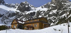


The mountain hut Chata pri Zelenom plese, formerly called Brnčalova chata, is located on the lake below Zmrzlá dolina and Cervená dolina. In winter, the sun does not shine on the hut at all. Starting point of the hike to Baranie sedlo. Typically start point, for the ski-alpine crossing High Tatra-Haute-Route.
Tours starting from hut
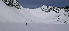
Ski tours around Hut Chata pri Zelenom plese
-
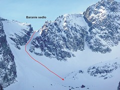
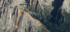
Baranie sedlo od Zeleného plesa 2387 m
Chata pri Zelenom plese High Tatras Slovakia
- Length of ascent2,5 km
- ascent850 m
- duration5-6,5 h
- Fitness difficulty ♦♦◊◊
- Technical difficulty ♦♦♦♦
From the lake "Zelené pleso" uphill through the narrowing between the rocks called "Flaška" (bottle). Simple part through the "Baraní Kotol". The end of the climb under the saddle is very steep (over 40 degrees) and also narrow. From the saddle you can climb to the summit "Baranie rohy" or descent to the mountain hut "Téryho chata". The descent back to "Chata pri Zelenom plese"is a ski technical challenge. The route through Baranie sedlo is part of the so-called High Tatras Haute Route.

-

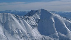
Baranie rohy od Zeleného plesa 2526 m
Chata pri Zelenom plese High Tatras Slovakia
- Length of ascent3 km
- ascent980 m
- duration5-7 h
- Fitness difficulty ♦♦♦◊
- Technical difficulty ♦♦♦♦
From the lake "Zelené pleso" uphill through the narrowing between the rocks called "Flaška" (bottle). Simple part through the "Baraní Kotol". The end of the climb under the saddle is very steep (over 40 degrees) and also narrow. From the saddle northwest of the ridge. Across the steep gully to a flat ridge to the summit.
- Country
- Slovakia
- Montains
- High Tatras
- Open (winter)
- daily
- Beds
- 56
- Winterraum
- no
- Shortening of access (cableway, lift, taxi, snowcat...)
- no
- Luggage transport
- no
- Card Pay
- no
- Shower
- no
- Wifi
- no
- UTM / CH1903 x ("longitude" E/W)
- 49°12.60606'
- UTM / CH1903 y ("latitude" N/S)
- 20°13.27542'
- GPX access to hut (waipoints, track)
- Zelene-pleso-CH-access_TRK.gpx
- Map
- Vysoké Tatry, 1:25000, Tatraplan, Nr. 2502 Vysoké Tatry 1:50000, VKÚ Harmanec, Nr. 113
- Guides
- Výber lyžiarskych a skialpinistických túr / slovensky
- Phone (hut)
- +421 901 767420
- Phone (valley)
- -
- Cell phone
- -
- Web
- chataprizelenomplese.sk
- tatry@chataprizelenomplese.sk
- Owner of hut
- KST (Klub slovenských turistov) a IAMES (horolezecký spolok)
- Chata pri Zelenom plese
- Reservation
- e-mail only
- Start Point
- Kežmarská Biela Voda - parking
- UTM / CH1903 x ("longitude" E/W)
- 49°11.21922'
- UTM / CH1903 y ("latitude" N/S)
- 20°17.54250'
- Altitude
- 930 m
- Ascent (height difference)
- 630 m
- Time of Access
- 2-3 h
- Shortening lift
- no
- Avalanche danger
- Stredisko lavinovej prevencie HZS
- Weather
- Chata pri Zelenom plese / Meteoblue.com HZS - počasí v horách HZS / Mountain Rescue login"user" - meteo station "Lomnický štít"a "Biele pleso" Lomnický štít 2634m / mountain-forecast.com Slovensko / shmu.sk Slovensko / meteo.sk Slovensko - meteograms / shmu.sk
- Snow report
- Slovensko / meteo.sk Tatranská Lomnica / bergfex.com Tatranská Lomnica / onthesnow.com Tatranská Lomnica / snow.cz Tatranská Lomnica / snow-forecast.com
- Webcams
- Chata pri Zelenom plese Lomnický štít
- Region
- travelguide.sk Tatry / e-slovensko.cz VysokeTatry.sk
- Public traffic
- Timetables / Cestovné poriadky
- Other links
- Slovakia Tourism slovakia.com
hut Chata pri Zelenom plese - Reviews
tomas.friedrich 20. 01. 2021
- nocleh ♦◊◊◊
- Staff ♦♦◊◊
- Food ♦♦♦◊
- Overall rating ♦♦◊◊
Video of ski tour
Best ski tours in mountains High Tatras, Slovakia
-
Furkotský štít 2404 m
Chata pod Soliskom - Štrbské Pleso High Tatras Slovakia
- Length of ascent3,5 km
- ascent650 m
- duration2,5-4 h
- Fitness difficulty ♦♦◊◊
- Technical difficulty ♦♦◊◊
Furkotský štít je oblíbený tatranský vrchol. Nejlépe je dostupný z Chaty pod Soliskom. Výstup vede Furkotskou dolinou přes Nižné a Vyšné Wahlenbergovo pleso. Za jezerem je možné vystupovat dvěma liniemi. Za dobrých podmínek širokým svahem (vlevo) na hřeben a po něm v mačkách na vrchol. Variantou výstupu je trasa přes Bystré sedlo. Tudy obvykle vede i trasa sjezdu. Návrat k chatě vyžaduje na krátký úsek nalepit pásy.
-
Patria 2203 m
Chata pod Soliskom - Štrbské Pleso High Tatras Slovakia
- Length of ascent5 km
- ascent840 m
- duration3-4,5 h
- Fitness difficulty ♦♦◊◊
- Technical difficulty ♦♦◊◊
Lyžařská túra ze Štrbského plesa na vrchol Patria nabízí možnost okružní trasy, sjezd vede Mlynickou dolinou.
-

Sedielková kopa 2062 m
Chata pod Soliskom - Štrbské Pleso High Tatras Slovakia
- Length of ascent6,5 km
- ascent920 m
- duration3,5-5 h
- Fitness difficulty ♦♦◊◊
- Technical difficulty ♦◊◊◊
Sedielková kopa je snadno dostupný vyhlídkový vrchol nad Štrbským plesem, dostupný i z Chaty pod Soliskom.
Best ski tours in Slovakia by skitour.guru
-
Baranec 2184 m
Žiarska chata Western Tatras Slovakia
- Length of ascent2,7 km
- ascent900 m
- duration4-5,5 h
- Fitness difficulty ♦♦♦◊
- Technical difficulty ♦♦♦♦
Baranec is the highest ski tour above the mountain hut Žiarska chata. The most popular variant is Jarný žlab. First, near the hut overcomes the creek. Then follow the ascent through the Jarný žlab, on the steep slope to the ridge. It goes up easier. It is recommended descent trough the Jarny žlab or the neighboring Maďarský žlab. The descent through the Baranecký kotol is very difficult and dangerous.
-
Žiarske sedlo 1917 m
Žiarska chata Western Tatras Slovakia
- Length of ascent6 km
- ascent615 m
- duration2,5-3,5 h
- Fitness difficulty ♦◊◊◊
- Technical difficulty ♦◊◊◊
Ziarske sedlo is the easiest ski tour in the region Žiarska dolina. The route follows the summer ascent and is mild. Ideal target with increased avalanche risk. The saddle is the gateway to the valley Jamnicka dolina.
-
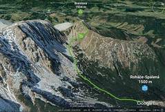
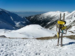
Brestová 1934 m
Zuberec - Penzion Šindlovec Western Tatras Slovakia
- Length of ascent2,5 km
- ascent430 m
- duration2-3 h
- Fitness difficulty ♦◊◊◊
- Technical difficulty ♦◊◊◊
450 vertical meters at the beginning can be saved with the cable car. Then through the valley Spálena dolina under the Přední Salatín and then right into the saddle and easy upwards. The descent follows ascent route.