
 Česky
Česky Deutsch


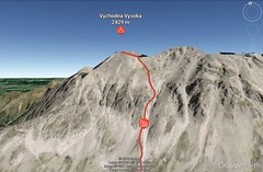


From the hotel "Sliezsky Dom" to the lake "Dlhé pleso" and further under the "Gulatý kopec". Then through the gutter up and left towards the saddle "Studené sedlo" and then along the ridge to the summit. As a rule, descend along the ascent track.
Peak
- Country
- Slovakia
- Montains
- Vysoké Tatry
- Tags
- Sliezsky Dom Slovakia Slovakia High Tatra Mountains Vysoké Tatry
- Hut
- Sliezsky Dom - horský hotel
- UTM / CH1903 x ("longitude" E/W)
- 34U 437728
- UTM / CH1903 y ("latitude" N/S)
- 5447281
Start point
- Start Point
- Sliezsky Dom - horský hotel
- Altitude
- 1670 m
- UTM / CH1903 x ("longitude" E/W)
- 49°09.35724'
- UTM / CH1903 y ("latitude" N/S)
- 20°09.39642'
- village, valley
- Velická Dolina
Conditions
- Avalanche danger
- Stredisko lavinovej prevencie HZS
- Weather
- Sliezsky dom / Meteoblue.com HZS / Mountain Rescue login"user" - meteo station "Sliezsky dom" HZS / Mountain Rescue login"user" - meteo station "Zamrznuté pleso" Gerlach 2655 m / mountain-forecast.com Slovensko / shmu.sk Slovensko / meteo.sk Slovensko - meteograms / shmu.sk
- Snow report
- Slovensko / meteo.sk Štrbské pleso / bergfex.com Štrbské pleso / onthesnow.com Štrbské pleso / snow.cz Štrbské pleso / snow-forecast.com Hrebienok - S.Smokovec / snow-forecast.com
- Webcams
- Sliezsky dom
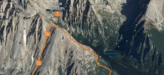
Ski tour map on Východná Vysoká


 bivakovací nouzová chata
  cepín a mačky potřeba
 exponovaný, obtížný terén
 horská chata
 hôtel, penzion
 lanovka, vlek
 lavinové nebezpečí, svah > 30°
 ledovcové trhliny
 lehká túra
 mimořádně obtížná túra
 mírně obtížná túra
 obtížná túra
 parkoviště
 přístup k chatě
 restaurace
 sedlo
sedlo sjezd
sjezd skidepo
 vrchol
 výstup
 začátek ledovce
- bivouac, winter room
- crampons & ice axe necessary
- exposed, difficulty terrain
- mountain hut, refuge
- hotel, pension
- cableway, skilift
- avalanche danger, slope > 30°
- glacier cracks
- little difficult tour
- extremely difficult tour
- rather difficult tour
- difficult tour
- parking
- hut acces
- restaurant
- col, pass, saddle
- descent
- skidepot
- peak, summit
- ascent
- glacier beginning
- biwak, winterraum
- steigeisen & pickel erforderlich
- ausgesetzt, schwierige gelände
- berghütte
- hotel, pension
- seilbahn, skilift
- lawinengefahr, hangneigung > 30°
- gletscherspalten
- wenig schwierige tour
- äusserst schwierige tour
- ziemlich schwierige tour
- schwierige tour
- parkplatz
- zugang zur hütte
- restaurant
- sattel, joch, pass
- abfahrt
- skidepot
- gipfel
- aufsieg
- gletscher anfang
- bivacco, locale invernale
- ramponi & piccozza necessari
- esposto, terreno difficolt?
- rifugio, capanna
- alberghi, pensione
- funivia, seggiovia
- pericolo di valanghe, pendenza > 30°
- crepe glacier
- tour piccolo difficile
- tour estremamente difficile
- tour piuttosto difficile
- escursioni difficili
- parcheggio
- accesso capanna
- ristorante
- col, sella, passo, forcella
- discesa
- sci deposito
- picco, vertice, piz
- salita
- inizio ghiacciaio
- bivouac, local d'hiver
- crampons & piolet nécessaire
- exposée, difficulté du terrain
- cabane de montagne, refuge
- hôtel, pension
- téléphérique, téléski
- danger d'avalanche, pente > 30°
- crevasse du glacier
- peu difficile tour
- extr?mement difficile tournée
- assez difficile tour
- difficile tournée
- parking
- acces cabane
- restaurant
- col, selle
- descente
- skis dépôt
- pic, sommet
- ascension
- début glacier
- < 20°
- 20° - 25°
- 25° - 30°
- 30° - 35°
- 35° - 40°
- > 40°
Current weather conditions in the tour area
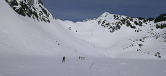
Planning of ski tour
- Fitness difficulty
-
- ♦♦◊◊
- Technical difficulty
-
- ♦♦♦◊
- best time for this tour
- Februar-April
- Glacier
- No
- Map
- Vysoké Tatry, 1:25000, Tatraplan, Nr. 2502 Vysoké Tatry 1:50000, VKÚ Harmanec, Nr. 113
- Guides
- Výber lyžiarskych a skialpinistických túr / slovensky
About Ski tour
- Time difficulty
- Ascent (height difference)
- 725 m
- Lenght of ascent
- 6 km
- Descent (height difference)
- 725 m
- Total Lenght of tour
- 3 km
- Total time of the tour
- 5-6,5 h
- Elevation Range
- 1670 - 2429 m
- Principal Aspect
- S S-south, N-north, W-west, E-east
Download
- KML (with POI)
- VychVysoka2429m_skitour.kml for viewing in the Google Earth 3D map application, which you can install on your PC
tour Východná Vysoká - Reviews
There are no reviews in this section yet. Click the Add Review button to add first review.
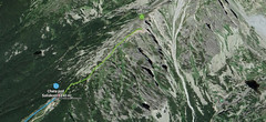
Ski tours around Hut Sliezsky Dom - horský hotel, in mountains Vysoké Tatry, Slovakia
-

Slavkovský štít 2452 m
Sliezsky Dom - horský hotel Vysoké Tatry Slovakia
- Length of ascent5 km
- ascent900 m
- duration6-7,5 h
- Fitness difficulty ♦♦♦◊
- Technical difficulty ♦♦♦◊
The mountain "Slavkovský štit" is a striking summit with southern slopes that starts from the lakes "Kotol Slavkovskych plies". The route leads through the southern ditch to the saddle "Sedlo za Nosom". From there follow the simple ridge to the summit. The descent follows the ascent route.

-

Litvorové sedlo 2375 m
Sliezsky Dom - horský hotel Vysoké Tatry Slovakia
- Length of ascent3,5 km
- ascent750 m
- duration4-5,5 h
- Fitness difficulty ♦♦◊◊
- Technical difficulty ♦♦♦◊
A ski tour from the mountain hotel Sliezsky Dom from the valley Velická dolina leads to the lake "Dlhé pleso" and then to the kar"Velický kotol" and further to the mountain lakes "Litvorove plesa". Uphill to the steeper slopes to Sattel Litvorové sedlo. The descent follows on ascent track.
Best ski tours in Vysoké Tatry by skitour.guru
-
Furkotský štít 2404 m
Chata pod Soliskom - Štrbské Pleso Vysoké Tatry Slovakia
- Length of ascent3,5 km
- ascent650 m
- duration2,5-4 h
- Fitness difficulty ♦♦◊◊
- Technical difficulty ♦♦◊◊
Furkotský štít je oblíbený tatranský vrchol. Nejlépe je dostupný z Chaty pod Soliskom. Výstup vede Furkotskou dolinou přes Nižné a Vyšné Wahlenbergovo pleso. Za jezerem je možné vystupovat dvěma liniemi. Za dobrých podmínek širokým svahem (vlevo) na hřeben a po něm v mačkách na vrchol. Variantou výstupu je trasa přes Bystré sedlo. Tudy obvykle vede i trasa sjezdu. Návrat k chatě vyžaduje na krátký úsek nalepit pásy.
-
Patria 2203 m
Chata pod Soliskom - Štrbské Pleso Vysoké Tatry Slovakia
- Length of ascent5 km
- ascent840 m
- duration3-4,5 h
- Fitness difficulty ♦♦◊◊
- Technical difficulty ♦♦◊◊
Lyžařská túra ze Štrbského plesa na vrchol Patria nabízí možnost okružní trasy, sjezd vede Mlynickou dolinou.
-
Predné Solisko 2117 m
Chata pod Soliskom - Štrbské Pleso Vysoké Tatry Slovakia
- Length of ascent1 km
- ascent245 m
- duration0,5-1 h
- Fitness difficulty ♦◊◊◊
- Technical difficulty ♦◊◊◊
Predné Solisko je snadná skialpová na vrchol přímo nad Chatou pod Soliskom. Dosažení vrcholu může být završením kondiční túry ze Štrbského plesa na Solisko.