
 Česky
Česky Deutsch


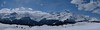
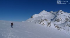
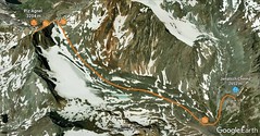
Piz d´Err is a popular ski tour to the panoramic summit. The technically undemanding ski tour begins in Chamanna Jenatsch. The only steep section is climbing on the summit. A first class experience is under stable conditions the descent to the opposite side, western slopes to Surselva, more precisely to the village Sur, a total of 1,800 m.
Peak
- Country
- Switzerland
- Montains
- Albula Alps
- Tags
- Albula Alps Engadin Graubünden Chamanna Jenatsch Switzerland
- Hut
- Chamanna Jenatsch / Jenatschhütte
- UTM / CH1903 x ("longitude" E/W)
- 772782
- UTM / CH1903 y ("latitude" N/S)
- 157332
Start point
Conditions
- Avalanche danger
- slf.ch - Institut für Schnee- und Lawinenforschung
- Weather
- Chamanna Jenatsch / meteoblue.com Piz Jenatsch / mountain-forecast.com Tschima da Flix / mountain-forecast.com Piz Calderas 3397m / meteoblue.com Chamanna Jenatsch / srf.ch Crasta Jenatsch / kachelmannwetter.com Piz Nair / yr.no Switzerland - animation / srf.ch St. Moritz / wetter.com Alpenvereinswetter
- Snow report
- Corviglia / snow-forecast.com Corviglia / onthesnow.com Corviglia / bergfex.ch Corviglia / snow.myswitzerland.com
- Webcams
- All webcams around St. Moritz
Current weather conditions in the tour area
Planning of ski tour
- Fitness difficulty
-
- ♦♦◊◊
- Technical difficulty
-
- ♦♦◊◊
- best time for this tour
- februar-april
- Glacier
- Yes
- Map
- S268 Julierpass, Swisstopo 1:50000 1257 St. Moritz, Swisstopo 1:25000 1256 Bivio, Swisstopo 1:25000 1237 Albulapass, Swisstopo 1:25000
- Guides
- Graubünden Süd / SAC-CAS.ch, deutsch Die klassischen Skitouren / SAC-CAS.ch, deutsch Les classiques de randonnée à ski / SAC-CAS.ch, francais
About Ski tour
- Time difficulty
- Ascent (height difference)
- - m
- Lenght of ascent
- km
- Descent (height difference)
- - m
- Total time of the tour
- h
- Elevation Range
- 0 - 3378 m
- Principal Aspect
- S-south, N-north, W-west, E-east
Download
Current avalanche potential on tour - Piz d´Err

tour Piz d´Err - Reviews
There are no reviews in this section yet. Click the Add Review button to add first review.
Ski tours around Hut Chamanna Jenatsch / Jenatschhütte, in mountains Albula Alps, Switzerland
-

Piz Surgonda 3196 m
Chamanna Jenatsch / Jenatschhütte Albula Alps Switzerland
- Length of ascent km
- ascent m
- duration h
- Fitness difficulty ♦♦◊◊
- Technical difficulty ♦♦◊◊
Piz Surgonda is an easier ski tour from Jenatschhütte, or from Piz Nair upper station (Corviglia Resort, supported by the cable car) or from Julier Pass. None of the variants pose a delicate risk. And next to it stands imposing Piz Julier.

-
Piz Calderas 3397 m
Chamanna Jenatsch / Jenatschhütte Albula Alps Switzerland
- Length of ascent km
- ascent745 m
- duration2,5-4 h
- Fitness difficulty ♦♦◊◊
- Technical difficulty ♦♦♦◊
Piz Calderas is a popular peak above Chamanna Jenatsch. From the valley above the hut turn left onto the northern slope of the glacier Vadret Calderas. Followed by travers to the glacial mulch and at the end of the southeast slope to the top. Downhill along the exit route.
-
Piz d´Agnel 3205 m
Chamanna Jenatsch / Jenatschhütte Albula Alps Switzerland
- Length of ascent km
- ascent m
- duration h
- Fitness difficulty ♦♦◊◊
- Technical difficulty ♦♦◊◊
-

Tschima Flix 3301 m
Chamanna Jenatsch / Jenatschhütte Albula Alps Switzerland
- Length of ascent km
- ascent650 m
- duration3-4 h
- Fitness difficulty ♦♦◊◊
- Technical difficulty ♦♦◊◊
Tschima Flix is one of the light ski tours. From the Jenatsch hut through the Calderas glacier, the traverse under the Piz Picuogl wall to the glacier saddle. From there easily to the top.
Best ski tours in Albula Alps by skitour.guru
-

Piz Kesch - Chamanna Kesch 3417 m
Keschhütte / Chamanna digl Kesch Albula Alps Switzerland
- Length of ascent4,5 km
- ascent845 m
- duration4,5-6 h
- Fitness difficulty ♦♦◊◊
- Technical difficulty ♦♦♦◊
Piz Kesch is a well-known mountain in the Albula Alps region, Piz Kesch clearly falls on the surrounding mountains. The view of Kesch can be enjoyed from Bernina, Muragl and other peaks. The ascent to the ski depot is easy. You go on / climb with an ice axe and crampons. The exposed terrain in places, the difficulty depends on the current snow conditions. Rope protection is usually not necessary. A perfect panoramic view from above.
-

Isenfürggli 2765 m
Davos Albula Alps Switzerland
- Length of ascent3 km
- ascent845 m
- duration2,5-3,5 h
- Fitness difficulty ♦♦◊◊
- Technical difficulty ♦♦◊◊
The ascent to the Isenfürggli saddle is a worthwhile addition after successful descents from Pischahorn or Isentällispitz. Especially in firn conditions or fresh powder, it is a rewarding destination. From the saddle, there is a beautiful view of the Silvretta range, with the striking Piz Linard as its centerpiece.
-

Gletscher Ducan 3019 m
Davos Albula Alps Switzerland
- Length of ascent6,5 km
- ascent1360 m
- duration5,5-7 h
- Fitness difficulty ♦♦◊◊
- Technical difficulty ♦♦♦◊
The Ducan Gletscher is a summit with a wonderful view of the Piz Kesch and especially the Piz Ela. The ski tour starts in Monstein, where the highest brewery in Europe is located. The Fanezfurgga saddle leads to valley with a striking mountain. The end of the climb up is usually with ice axe and crampons. The descent through the Ducantal valley is oriented to the north and leads skiers into the Sertigtal valley. The route can also be done in the opposite direction. It is advisable to undertake the tour with the support of public transport.