
 Česky
Česky Deutsch


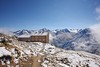


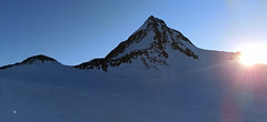
The Breslauer Hütte is an ideal starting point to climb the Wildspitze, the highest mountain in the Ötztaler Alps. In winter there is no staff, there is a winter room available. The house is accessible from Vent. If a chairlift is in operation (usually until Easter) you can shorten the approach to the mountain hut considerably.
Tours starting from hut
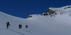
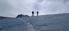
Ski tours around Hut Breslauer Hütte
- Country
- Austria
- Montains
- Ötztal Alps / Alpi Venoste
- Open (winter)
- in winter is closed
- Beds
- 166
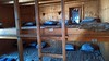
- Winterraum
- open, 22 beds
- Shortening of access (cableway, lift, taxi, snowcat...)
- yes, by cableway from Vent
- Luggage transport
- no
- Card Pay
- no
- Shower
- no
- Wifi
- no
- UTM / CH1903 x ("longitude" E/W)
- 32T 643241
- UTM / CH1903 y ("latitude" N/S)
- 5192223
- GPX access to hut (waipoints, track)
- Breslauer-Hut_access_Vent_skitour.gpx
- GPX access to hut (track only)
- BreslauerH_access_TRK.gpx
- GPX all tours from the hut
- Wildspitze_Breslauer-Hut_skitour.gpx
- Map
- Ötztaler Alpen Wildspitze, OEAV 1:25000, Nr. 30/6 Ötztaler Alpen Weisskugel, OEAV 1:25000, Nr. 30/2
- Guides
- Ötztal – Silvretta / Bergverlag Rother, deusch SCHITOUREN-ATLAS ÖSTERREICH WEST / Schall Verlag, deusch Skitourenführer Ötztaler Alpen / Panico, deusch
- Phone (hut)
- 0043/664/5300898
- Phone (valley)
- 0043/5254/30117
- Cell phone
- -
- Mobile Signal
- yes
- Web
- BreslauerHuette.at
- info@breslauerhuette.at
- Owner of hut
- DAV Sektion Breslau / Sitz Stuttgart
- Start Point
- Vent
- UTM / CH1903 x ("longitude" E/W)
- 32T 64595
- UTM / CH1903 y ("latitude" N/S)
- 5191393
- Altitude
- 1885 m
- Ascent (height difference)
- 970 m
- Time of Access
- 2-3 h
- Shortening lift
- yes, by cablecar from Vent, until mid April
- Avalanche danger
- lawine.at
- Weather
- Breslauer Hütte / yr.no Vent skiresort, snow-forecast.com Wildspitze 3772m / mountain-forecast.com Hint. Brochkogel 3625m / mountain-forecast.com Ramolkogel 3549m / mountain-forecast.com Bergwetter Tirol 2 days Alpenverein.at Austria / ZAMG Tirol / ORF
- Snow report
- Vent / bergfex.at Vent / snow-forecast.com Sölden / onthesnow.com Sölden / schneeradar.de
- Webcams
- Vent Vernagthütte Rif. Bella Vista / Schöne Aussicht Hütte Sölden-Rettenbachgletscher
- Region
- Vent Ötztal
- Public traffic
- OBB Raiway Postbus
- Skiresort nearby
- Vent Pitztaler Gletscher Sölden
- Other links
- Austria Tourism
hut Breslauer Hütte - Reviews
There are no reviews in this section yet. Click the Add Review button to add first review.
Best ski tours in mountains Ötztal Alps / Alpi Venoste, Austria
-
Schalfkogel E (Langtalereck H.) 3537 m
Langtalereckhütte Ötztal Alps / Alpi Venoste Austria
- Length of ascent7 km
- ascent1500 m
- duration5,5-7 h
- Fitness difficulty ♦♦♦◊
- Technical difficulty ♦♦♦◊
Schalfkogel (Langtalereck Hütte, Ötztaler Alpen) is a relatively demanding tour. After climbing the glacier Gurgler Ferner is a challenging steep steep part of the glacier Kleinleiten Ferner. From the saddle Schalfkogeljoch longer and harder ascent without skis. The mountain is also accessible from Martin Busch Hütte.

-
Hintere Schwärze 3624 m
Martin-Busch-Hütte Ötztal Alps / Alpi Venoste Austria
- Length of ascent6,5 km
- ascent1300 m
- duration5,5-7 h
- Fitness difficulty ♦♦◊◊
- Technical difficulty ♦♦♦◊
Hintere Schwärze je vrchol, schovaný trošku stranou. Patří mezi top10 nejvyšších hor Rakouska. Po sjezdu od chaty se trasa stáčí doprava na ledovec Marzellferner. Po ledovci mírně nahoru. Následuje prudší svah k závěrečnému výšvihu. Od skidepa v mačkách a s cepínem na vrchol, jednoduchým terénem.
-
Finailspitze North (from Hochjoch Hospiz) 3514 m
Hochjoch Hospiz Ötztal Alps / Alpi Venoste Austria
- Length of ascent7 km
- ascent1390 m
- duration5,5-7 h
- Fitness difficulty ♦♦♦◊
- Technical difficulty ♦♦♦◊
The tour to Fineilspitze begins with a short descent from the Hochjoch Hospiz hut into the valley of the Rofenache stream. Cross the stream and ascend on the right-hand side above the gorge. After the valley widens, continue left up over a moraine onto the glacier. On the glacier, head right of the ridge to a point at 3447 m. Leave the skis there and continue without them, using crampons, over exposed terrain along the ridge to the summit. Descent follows the ascent route.
Best ski tours in Austria by skitour.guru
-

Sulzfluh N 2818 m
Lindauer Hütte Rätikon Austria
- Length of ascent5,5 km
- ascent1300 m
- duration5-7 h
- Fitness difficulty ♦♦♦◊
- Technical difficulty ♦♦♦◊
Sulzfluh (Lindauer Hütte, Rätikon) is a very challenging ski tour through the rocky slopes "In der Rachen" (in the throat). From the top are great views of the mountains of eastern Switzerland and Silvretta.
-
Grosses Degenhorn 2937 m
Innervillgraten Villgratner Berge - Deferegger Alpen Austria
- Length of ascent11 km
- ascent1470 m
- duration7,5-9,5 h
- Fitness difficulty ♦♦♦◊
- Technical difficulty ♦♦◊◊
Skialpová túra na Grosses Degenhorn míří na jeden z nejvyšších vrcholů pohoří Villgraten, a proto je z něj skvělý výhled. Nádherný firnový sjezd si musíte zasloužit dlouhým výstupem přes údolí Arntal. Díky své výšší poloze je možné túru podniknout i v květnu. V jarních podmínkách je nutné počítat s dlouhou chůzí bez lyží údolím Arntal.
-

Nockberge Trail Day 2 2336 m
Innerkrems - Mehrlhütte Nockberge Austria
- Length of ascent10,5 km
- ascent1210 m
- duration6-8 h
- Fitness difficulty ♦♦♦◊
- Technical difficulty ♦♦♦◊
2. etapa 4denního skialpového přechodu Nockberge Trail vede z Innerkremsu na Turracher Höhe a je ze všech nejnáročnější - jak délkou, převýšenm tak i technickou náročností. Oblé kopce alpského pohoří Nockberge mají jedinou nevýhodu - vítr z jejich svahů často odfoukne sníh a je ho místy nedostatek. Po bezproblémovém výstupu na Königstuhl a Karlnock následuje sjezd do sedla Stangnock a pak po širokém hřebenu nahoru na Gregerlnock. Následující sjezd poměrně prudkým svahem má lavinový potenciál - buďte pozorní, v případě špatných podmínek sjíždějte po hřebenu do míst, kde je svah mírnější. Po sjezdu na alm následuje orientačně zapeklitá fáze - držte se striktně linie v GPS. Za potokem začíná výstup na Winkler Alm. Cesta na sjezdovku nevede přes les (pozor na stopy). Až dorazíte k sjezdovce, musíte ještě vystoupat k lanovce Schafalmbahn (na dohled) a po sjezdovce č.1 na sedlo Turracher Höhe.