
 Česky
Česky Deutsch


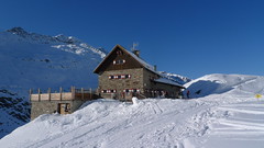
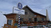
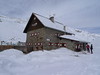
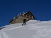


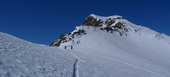
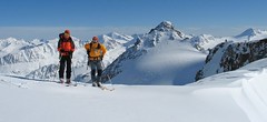
Langtalereckhütte is the mountain hut in the east of the Ötztal Alps above Obergurgl. It offers medium and very hard skitours, one of the highest areas of the Eastern Alps. Six Tours - Annakogel, Eiskögele, Hinterer Seelenkogel, Hochwilde, Mittlerer Seelenkogel, Schalfkogel, one nicer than the other. Easily accessible from the skiarea Obergurgl, help for access via the Steinmannbahn cable car.
Tours starting from hut
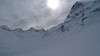
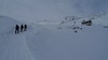
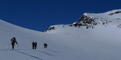
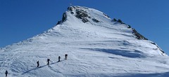
Ski tours around Hut Langtalereckhütte
-
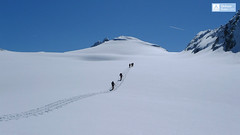
Annakogel 3336 m
Langtalereckhütte Ötztal Alps / Alpi Venoste Austria
- Length of ascent8 km
- ascent1300 m
- duration5-7 h
- Fitness difficulty ♦♦♦◊
- Technical difficulty ♦♦◊◊
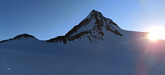
ANNAKOGEL is the lightest tour of the Langtalereck Hütte on the glacier Gurgler Ferner in the Tyrol Ötztaler Alpen. Beautiful view of Schalfkogel and Hohe Wilde.

-

Hohe Wilde / Hochwilde 3461 m
Langtalereckhütte Ötztal Alps / Alpi Venoste Austria
- Length of ascent8 km
- ascent1040 m
- duration6-8 h
- Fitness difficulty ♦♦♦◊
- Technical difficulty ♦♦♦♦
Hohe Wilde (Langtalereck Hütte, Ötztaler Alpen) is a distinctive mountain at the end of the Langtaler Ferner glacier with a challenging finisch to the summit.
-

Eiskögele 3228 m
Langtalereckhütte Ötztal Alps / Alpi Venoste Austria
- Length of ascent3 km
- ascent800 m
- duration1,5-2 h
- Fitness difficulty ♦♦◊◊
- Technical difficulty ♦♦♦◊
Eiskögele is a good moderate tour for the last day on the Langtalereckhütte (Ötztaler Alpen). After climbing to the top, you can get off the saddle on the edge of the Obergurgl ski resort and down the slopes to the village.
-
Schalfkogel E (Langtalereck H.) 3537 m
Langtalereckhütte Ötztal Alps / Alpi Venoste Austria
- Length of ascent7 km
- ascent1500 m
- duration5,5-7 h
- Fitness difficulty ♦♦♦◊
- Technical difficulty ♦♦♦◊
Schalfkogel (Langtalereck Hütte, Ötztaler Alpen) is a relatively demanding tour. After climbing the glacier Gurgler Ferner is a challenging steep steep part of the glacier Kleinleiten Ferner. From the saddle Schalfkogeljoch longer and harder ascent without skis. The mountain is also accessible from Martin Busch Hütte.
-
Hinterer Seelenkogel 3475 m
Langtalereckhütte Ötztal Alps / Alpi Venoste Austria
- Length of ascent9 km
- ascent1140 m
- duration5-7 h
- Fitness difficulty ♦♦♦◊
- Technical difficulty ♦♦◊◊
Hinterer Seelenkogel (Langtalereck Hütte, Ötztaler Alpen) is a ski tour between North and South Tyrol. Avalanche danger wait at the beginning of the exit from the Langtal valley.
-

Mittlerer Seelenkogel 3426 m
Langtalereckhütte Ötztal Alps / Alpi Venoste Austria
- Length of ascent5 km
- ascent1000 m
- duration4-5,5 h
- Fitness difficulty ♦♦◊◊
- Technical difficulty ♦♦♦◊
Mittlerer Seelenkogel (Langtalereck Hütte, Ötztaler Alpen) is a rather difficult skitour for his second half. Traverse in steep terrain and the finish can be done under good conditions only.
- Country
- Austria
- Montains
- Ötztal Alps / Alpi Venoste
- Open (winter)
- mid february - mid may
- Beds
- 73
- Winterraum
- 0
- Shortening of access (cableway, lift, taxi, snowcat...)
- yes, by snowcat
- UTM / CH1903 x ("longitude" E/W)
- 32T 651928
- UTM / CH1903 y ("latitude" N/S)
- 5188048
- GPX access to hut (waipoints, track)
- Langtalereck-Huette-access.gpx
- GPX access to hut (track only)
- Langtalereck Hütte access_TRK.gpx
- GPX all tours from the hut
- Langtalereck-Huette-TRACKS_WPT AUT Tirol SkitourGuru.gpx
- Map
- Gurgl, OEAV 1:25000, Nr. 30/1
- Guides
- Skitourenführer Tirol Ötztal – Silvretta SCHITOUREN-ATLAS ÖSTERREICH WEST
- Phone (hut)
- 0043/664/5268655
- Phone (valley)
- 0043/5253/5396
- Cell phone
- -
- Web
- www.alpenverein-karlsruhe.de
- -
- Owner of hut
- DAV Sektion Karlsruhe
- Langtalereckhütte & Hochwildehaus
- Start Point
- Obergurgl-parking
- UTM / CH1903 x ("longitude" E/W)
- 32 T 654452
- UTM / CH1903 y ("latitude" N/S)
- 5192814
- Altitude
- 1910 m
- Ascent (height difference)
- 600 m
- Time of Access
- 2,5-3,5 h
- Shortening lift
- Steinmannbahn
- Avalanche danger
- LWD Tirol
- Weather
- ZAMG ORF wetter.at bergfex.at yr.no - Langtalereckhütte yr.no - Mittl. Seelenkogel yr.no - Schalfkogel
- Snow report
- snow-forecast.com schneeradar.de
- Webcams
- Webcams Travel schneeradar.de
- Region
- Obergurgl Ötztal
- Public traffic
- Postbus ÖBB Railway
- Skiresort nearby
- Obergurgl-Hochgurgl
hut Langtalereckhütte - Reviews
There are no reviews in this section yet. Click the Add Review button to add first review.
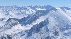
Best ski tours in mountains Ötztal Alps / Alpi Venoste, Austria
-
Schalfkogel West (from M.Busch Hut) 3537 m
Martin-Busch-Hütte Ötztal Alps / Alpi Venoste Austria
- Length of ascent7,5 km
- ascent1200 m
- duration4,5-6 h
- Fitness difficulty ♦♦♦◊
- Technical difficulty ♦♦♦◊
Túra na Schalfkogel od chaty Martin Busch Hütte začíná sjezdem do údolí a pokračuje úzkým koridorem pod ledovcovými morénami východním směrem do sedla Schalfkogeljoch. Zde je skidepot a na vrchol v mačkách a s cepínem. Dolů po trase výstupu.
-
Fluchtkogel SE, from Vernagthütte 3500 m
Vernagthütte Ötztal Alps / Alpi Venoste Austria
- Length of ascent4 km
- ascent740 m
- duration3-4,5 h
- Fitness difficulty ♦♦♦◊
- Technical difficulty ♦♦◊◊
Túra na Fluchtkogel z Vernagthütte je výletem za krásnými výhledy přes celé Ötztálské Alpy. Jediný prudší úsek je pod sedle Oberes Guslarjoch a ještě v závěrečném svahu na plochý vrchol. Dolů kolem výstupových stop.
-
Finailspitze North (from Hochjoch Hospiz) 3514 m
Hochjoch Hospiz Ötztal Alps / Alpi Venoste Austria
- Length of ascent7 km
- ascent1390 m
- duration5,5-7 h
- Fitness difficulty ♦♦♦◊
- Technical difficulty ♦♦♦◊
The tour to Fineilspitze begins with a short descent from the Hochjoch Hospiz hut into the valley of the Rofenache stream. Cross the stream and ascend on the right-hand side above the gorge. After the valley widens, continue left up over a moraine onto the glacier. On the glacier, head right of the ridge to a point at 3447 m. Leave the skis there and continue without them, using crampons, over exposed terrain along the ridge to the summit. Descent follows the ascent route.
Best ski tours in Austria by skitour.guru
-

Hochstein 2827 m
Innervillgraten Villgraten Mountains – Deferegger Alps Austria
- Length of ascent6,5 km
- ascent1150 m
- duration4-6 h
- Fitness difficulty ♦♦♦◊
- Technical difficulty ♦♦◊◊
Skialpová túra na Hochstein je členitá a zajímavá. Za almem Kamelisenalm se stoupá mírným táhlým západním svahem do sedla Öwelenke. Krátký sjezd na pásech a hned doleva traverzem směrem k jezeru (nesjíždět až dolů k potoku). Nejprudší výstup túry je z kotliny nad jezerem. Závěr výstupu na vrchol vede táhlým mírným svahem. Sjezd po trse výstupu. Alternativou je za dobrých podmínek přelezení hřebínku z posledního sedla do sektoru trasy na Rotes Kinkele a po dosažení vrcholu sjíždet trasou z Rotes Kinkele, která je sjezdařsky zajímavější.
-
Weisseck 2711 m
Zederhaus - Kirchenwirt Niedere Tauern Austria
- Length of ascent7 km
- ascent1450 m
- duration5-7 h
- Fitness difficulty ♦♦♦◊
- Technical difficulty ♦♦♦◊
Ski tour to the impressive Weisseck. In good conditions, a spectacular Ödenkar boiler descent is offered. If we don't climb to the Weisseck, the beautiful Ferskarspitze is on the way. Through the forest you reach the valley "In hell" (In der Hölle) - on one side of the rock towers, on the other side of the wall of Weisseck. Enter the Ödenkar from the upper plateau with the summit cross and watch out for snow guards and a very steep start.
-

Pürglesgungge 2500 m
Kalkstein - Villgratental Villgraten Mountains – Deferegger Alps Austria
- Length of ascent4 km
- ascent890 m
- duration4-5,5 h
- Fitness difficulty ♦♦◊◊
- Technical difficulty ♦◊◊◊
Skialpová túra na Pürglesgungge je nádherná nad hranicí lesa. Krásné výhledy dolů do údolí Villgratental a do protějšího údolí Marchental s výstupem na Marchkinkele. Rozsáhlý terén nabízí za bezpečných podmínek skvělý sjezd do údolí Alfental.