
 Česky
Česky Deutsch


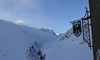


The Hochjoch Hospiz is a mountain hut that can be reached from Vent along the Rofen Ache stream. In some sections, the approach to the hut can be adventurous. From the hut are frequent destinations for ski mountaineers the monumental Weißkugel, the Fineilspitze (Similaunhütte) and the Guslarspitze (Vernagthütte). The Hochjoch Hospiz is the base on Venter Skicircuit, 5-day haute route through the Ötztal Alps.
Tours starting from hut
Ski tours around Hut Hochjoch Hospiz
-
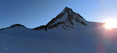
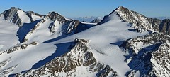
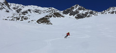
Finailspitze North (from Hochjoch Hospiz) 3514 m
Hochjoch Hospiz Ötztal Alps / Alpi Venoste Austria
- Length of ascent7 km
- ascent1390 m
- duration5,5-7 h
- Fitness difficulty ♦♦♦◊
- Technical difficulty ♦♦♦◊
The tour to Fineilspitze begins with a short descent from the Hochjoch Hospiz hut into the valley of the Rofenache stream. Cross the stream and ascend on the right-hand side above the gorge. After the valley widens, continue left up over a moraine onto the glacier. On the glacier, head right of the ridge to a point at 3447 m. Leave the skis there and continue without them, using crampons, over exposed terrain along the ridge to the summit. Descent follows the ascent route.

-

Weisskugel East, from Hochjoch Hospiz 3739 m
Hochjoch Hospiz Ötztal Alps / Alpi Venoste Austria
- Length of ascent11 km
- ascent1550 m
- duration7-10 h
- Fitness difficulty ♦♦♦♦
- Technical difficulty ♦♦♦◊
Skialpinistická túra na Weisskugel je obtížná především svou délkou. Začátek túry se liší podle sněhové situace. Když je málo sněhu, jde se po rampě, víceméně po vrstevnici k ledovci Hintereisferner. Po ledovci mírně nahoru západním směrem. Prudký je až výšvih do sedla Hintereisjoch, odkud se stoupá doprava, severním směrem k vrcholu. Poslední desítky metrů vedou exponovaným terénem, hodně záleží na množství sněhu.
-

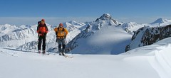
Fluchtkogel S, from Hochjoch Hospiz 3500 m
Hochjoch Hospiz Ötztal Alps / Alpi Venoste Austria
- Length of ascent6 km
- ascent1130 m
- duration3,5-5 h
- Fitness difficulty ♦♦♦◊
- Technical difficulty ♦♦◊◊
Skialpová túra na Fluchtkogel z chaty Hochjoch Hospiz slibuje zajímavý výstup a skvělý výhled z vrcholu. Od chaty traverzem mírně vzhůru (ne moc doprava nahoru) tak, abyste dosáhli spodního okraje ledovcového karu. Úzkým koridorem po prudším výšvihu ke spodnímu okraji ledovce Kesselwandferner. Po mírném rozlehlém ledovci k sedlu Guslarjoch. Závěr výstupu na plochý vrchol je po místy prudkém svahu. Pokud chcete sjet k chatě Vernagthütte, z vrcholu sjeďtze k sedlu Guslarjoch a po ledovci Guslarferner a následně členitým terénem k chatě. V případě návratu na Hochjoch Hospiz sjezd po trase výstupu.
-

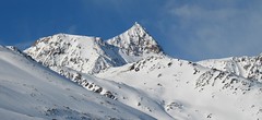
Guslarspitze S, from Hochjoch Hospiz 3138 m
Hochjoch Hospiz Ötztal Alps / Alpi Venoste Austria
- Length of ascent3 km
- ascent720 m
- duration2-3 h
- Fitness difficulty ♦♦◊◊
- Technical difficulty ♦♦◊◊
Túra na Guslarspitze z chaty Hochjoch Hospiz není příliš náročná. Stoupá se přímo z chaty jižním svahem. Sklon svahu se plynule zvětšuje. Po vrcholovém hřebenu je to kousek ke kříži. Sjezd po trase výstupu. Přes Guslarspitze vede nejjednodušší trasa k chatě Vernagthütte.
- Country
- Austria
- Montains
- Ötztal Alps / Alpi Venoste
- Open (winter)
- March - beginning May
- Beds
- 70
- Winterraum
- open, 16 beds
- Shortening of access (cableway, lift, taxi, snowcat...)
- no
- Luggage transport
- no
- Card Pay
- no
- Shower
- yes
- Wifi
- yes
- UTM / CH1903 x ("longitude" E/W)
- 32T 639906
- UTM / CH1903 y ("latitude" N/S)
- 5187362
- GPX access to hut (waipoints, track)
- HochjochHospiz_access_Vent_skitour.gpx
- GPX access to hut (track only)
- HochjochH_access_Vent_TRK.gpx
- GPX all tours from the hut
- HochjochH_ALL_skitour.gpx
- Map
- Weisskugel, OEAV 1:25000, Nr. 30/2
- Guides
- Ötztal – Silvretta / Bergverlag Rother, deusch SCHITOUREN-ATLAS ÖSTERREICH WEST / Schall Verlag, deusch Skitourenführer Ötztaler Alpen / Panico, deusch
- Phone (hut)
- +43 720 920311
- Phone (valley)
- -
- Cell phone
- +43 (0) 664 7980757
- Mobile Signal
- yes
- Web
- hochjoch-hospiz.at
- info@hochjoch-hospiz.at
- Owner of hut
- DAV Sektion Berlin
- Hochjoch Hospiz
- Reservation
- online form
- Online reservation
- hochjoch-hospiz.at
- Start Point
- Rofenhöfen / Vent
- UTM / CH1903 x ("longitude" E/W)
- 10.891094°
- UTM / CH1903 y ("latitude" N/S)
- 5190866
- Altitude
- 2020 m
- Ascent (height difference)
- 640 m
- Time of Access
- 2,5 - 3 h
- Shortening lift
- no
- Avalanche danger
- lawine.at
- Weather
- Hochjoch Hospiz / meteoblue.com Bergwetter Tirol 2 days Vent, snow-forecast.com Guslarspitzen 3147 / mountain-forecast.com Fineilspitze 3514 / mountain-forecast.com Fluchtkogel / meteoblue.com Weisskugel 3739 m / mountain-forecast.com Alpenvereinswetter wetter.at - Austria ZAMG - Austria ORF Wetter
- Snow report
- Vent / bergfex.at Vent / snow-forecast.com Sölden / schneeradar.de Sölden / onthesnow.com
- Webcams
- Vernagthütte Vent Rif. Bella Vista / Schöne Aussicht Hütte Sölden-Rettenbachgletscher
- Region
- Vent Ötztal
- Public traffic
- Postbus
- Skiresort nearby
- Sölden
- Other links
- Austria Tourism
hut Hochjoch Hospiz - Reviews
There are no reviews in this section yet. Click the Add Review button to add first review.
Best ski tours in mountains Ötztal Alps / Alpi Venoste, Austria
-
Similaun N, from Similaunhütte 3606 m
Similaunhütte - Rifugio Similaun Ötztal Alps / Alpi Venoste Austria
- Length of ascent3 km
- ascent650 m
- duration2,5-3,5 h
- Fitness difficulty ♦♦◊◊
- Technical difficulty ♦♦♦◊
Vrchol Similaun od chaty Similaunhütte vede po severovýchodních svazích, převážně po ledovci Niederjochferner. Od chaty na lyžích do skidepotu, a v mačkách s cepínem k vrcholovému kříži.
-
Fluchtkogel SE, from Vernagthütte 3500 m
Vernagthütte Ötztal Alps / Alpi Venoste Austria
- Length of ascent4 km
- ascent740 m
- duration3-4,5 h
- Fitness difficulty ♦♦♦◊
- Technical difficulty ♦♦◊◊
Túra na Fluchtkogel z Vernagthütte je výletem za krásnými výhledy přes celé Ötztálské Alpy. Jediný prudší úsek je pod sedle Oberes Guslarjoch a ještě v závěrečném svahu na plochý vrchol. Dolů kolem výstupových stop.
-
Wildspitze - Vernagt Hütte to Vent 3770 m
Vernagthütte Ötztal Alps / Alpi Venoste Austria
- Length of ascent7,5 km
- ascent1100 m
- duration7-9 h
- Fitness difficulty ♦♦♦◊
- Technical difficulty ♦♦♦♦
Trasa výstupu je shodná z túrou z chaty Vernagthütte. Při sjezdu odbočte doleva k sedlu Mitterkarjoch. Velký pozor na trhliny na okraji ledovce. Varianta z ledovce doleva vede strmým, vysněženým svahem. Varianta pravá, přes Mitterkarjoch poskytuje při nižší sněhové pokrývce sestup přes feratu obtížnosti B/C. Po vyjetí ze strmých svahů traverzujtedoleva s co nejmenší ztrátou výšky velkým kotlem k chatě Breslauer. Od chaty zpočátku přes strmý svah k horní stanici lanovky ze skiareálu Vent. Po sjezdovkách dolů na parkoviště. Túra jen pro zkušené alpinisty - výborné lyžaře a schopnosti lézt ve skalním terénu!
Best ski tours in Austria by skitour.guru
-

Stubacher Sonnblick 3088 m
Rudolfshütte Berghotel Granatspitz Group - Hohe Tauern Austria
- Length of ascent5 km
- ascent920 m
- duration3-4,5 h
- Fitness difficulty ♦♦◊◊
- Technical difficulty ♦♦◊◊
Stubacher Sonnblick z Rudolfshütte je sázka na jistotu. Varianta výstupové i sjezdové linie. Závěrečných 150 výškových metrů mezi ledovcem a vrcholem tvoří kamenná pyramida. Pokud jsou dobré sněhové podmínky, dá se vystoupat na lyžích až k vrcholovému kříži. Z vrcholu je krásný výhled k západu na dominantní rozložitý masiv Grossvenedigeru. Jihovýchodnímu směru jasně kraluje nejvyšší rakouská hora – Grossglockner.
-
Schlieferspitze 3289 m
Kürsinger Hütte Venedigergruppe - Hohe Tauern Austria
- Length of ascent7,5 km
- ascent1050 m
- duration5-6,5 h
- Fitness difficulty ♦♦♦◊
- Technical difficulty ♦♦♦◊
Relatively demanding glacier ski tour on 3289 m Schlieferspitze leads glacial terrain. To stay on Kürsinger Hut fits is Schlieferspitze ideal tour for the last day. After ascent to descent the eastern slopes and valleys Sulzbachtal the parking lot. When staying overnight at Postalm is actually the only option for the ascent.
-
Ruderhofspize S (from Stubai Valley) 3473 m
Stubai - Mutterbergalm (cable car) Stubai Alps Austria
- Length of ascent6,5 km
- ascent1770 m
- duration5,5-7 h
- Fitness difficulty ♦♦♦◊
- Technical difficulty ♦♦◊◊
Ruderhofspitze je velkolepá túra širokým jižním svahem, až poslední desítky metrů se musí jít bez lyží. Sjezd po trase výstupu je víceméně příjemného sklonu, většinou mezi 20-25 stupni a hlavně na jarním firnu to je velkolepé svezení.