
 Česky
Česky Deutsch


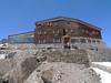


Similaunhütte is a private mountain hut on the border between Austria and Italy. The main destinations for ski mountaineers are Similaun and Fineilspitze or the Hauslabkogel. It is best reached from Vent (Ötztal) or the nearby Martin Busch Hütte. Similaunhütte is the base at the popular ski crossing Venter ski circuit through the Ötztal Alps in the haute route style.
Tours starting from hut
Ski tours around Hut Similaunhütte - Rifugio Similaun
-
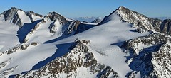
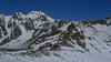
Similaun N, from Similaunhütte 3606 m
Similaunhütte - Rifugio Similaun Ötztal Alps / Alpi Venoste Austria
- Length of ascent3 km
- ascent650 m
- duration2,5-3,5 h
- Fitness difficulty ♦♦◊◊
- Technical difficulty ♦♦♦◊
Vrchol Similaun od chaty Similaunhütte vede po severovýchodních svazích, převážně po ledovci Niederjochferner. Od chaty na lyžích do skidepotu, a v mačkách s cepínem k vrcholovému kříži.

-

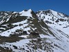
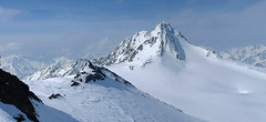
Hauslabkogel from Similaunhütte 3403 m
Similaunhütte - Rifugio Similaun Ötztal Alps / Alpi Venoste Austria
- Length of ascent3,5 km
- ascent750 m
- duration3-4 h
- Fitness difficulty ♦♦◊◊
- Technical difficulty ♦♦◊◊
Hauslabkogel je oblíbený vyhlídkový vrchol, poměrně snadno dostupnbý jak z chaty Similaunhütte, tak z Martin-Busch Hütte. Po krátkém sjezdu z chaty Similaun nastává plynulý výstup svahem konstantního sklonu. V závěrečné části výstupu pozor na ledovcové trhliny.
-
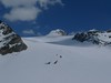
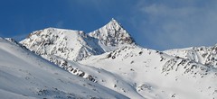
Fineilspitze East, from Similaunhütte 3514 m
Similaunhütte - Rifugio Similaun Ötztal Alps / Alpi Venoste Austria
- Length of ascent3,5 km
- ascent760 m
- duration4-5,5 h
- Fitness difficulty ♦♦♦◊
- Technical difficulty ♦♦♦♦
Výlézt na vrchol Fineilspitze po východním hřebenu od chaty Similaunhütte je v závěru velmi náročný úkol. Hlavně kvůli exponovanému hřebenu na vrchol. Pod chatou Similaunhütte odbočte po krátkém sjezdu vlevo a jednoduchým terénem dojdete až k památníku nálezu "ledového muže - Ötziho. Nastává strmější výstup do sedla Hauslabjoch. Kousek pod sedlem je příhodné místo na skidepot. V mačkách po vzdušném hřebenu na vrchol. Velký pozor při náročném sestupu. Když se nechcete vrátit na chatu Similaunhütte, můžete sjet do ledovci směrem k chatě Hochjoch Hospiz. Obtížnější variantou je přelézt hřeben s lažemi na batohu a západním hřebenem sestoupit k chatě Rifugio Bella Vista.
- Country
- Austria
- Montains
- Ötztal Alps / Alpi Venoste
- Open (winter)
- mid March - beginning May
- Beds
- 95
- Winterraum
- no
- Shortening of access (cableway, lift, taxi, snowcat...)
- no
- Luggage transport
- no
- Card Pay
- no
- Shower
- yes
- Wifi
- no
- UTM / CH1903 x ("longitude" E/W)
- 32T 641613
- UTM / CH1903 y ("latitude" N/S)
- 5181535
- GPX access to hut (waipoints, track)
- SimilaunHut_access_skitour.gpx
- GPX access to hut (track only)
- SimilaunHte_access_TRK.gpx
- Map
- Weisskugel, OEAV 1:25000, Nr. 30/2
- Guides
- Ötztal – Silvretta / Bergverlag Rother, deusch SCHITOUREN-ATLAS ÖSTERREICH WEST / Schall Verlag, deusch Skitourenführer Ötztaler Alpen / Panico, deusch
- Phone (hut)
- +39/0473/669711, +43 720 920 4
- Phone (valley)
- 0043525430122
- Cell phone
- +43/676 5074502
- Mobile Signal
- yes
- Web
- similaunhuette.com
- info@similaunhuette.com (only out of season )
- Owner of hut
- privat
- Similaunhütte - Rifugio Similaun
- Reservation
- phone only
- Start Point
- Vent
- UTM / CH1903 x ("longitude" E/W)
- 32T 64595
- UTM / CH1903 y ("latitude" N/S)
- 5191393
- Altitude
- 1885 m
- Ascent (height difference)
- 1200 m
- Time of Access
- 4-5 h
- Shortening lift
- no
- Avalanche danger
- lawine.at
- Weather
- Hochjoch Hospiz / meteoblue.com Bergwetter Tirol 2 days Vent, snow-forecast.com Similaun 3606 / mountain-forecast.com Fineilspitze 3514 / mountain-forecast.com Mutmalspitze 3522m / meteoblue.com Weisskugel 3739 m / mountain-forecast.com Grawand 3251m / mountain-forecast.com Alpenvereinswetter ZAMG - Austria ORF Wetter
- Snow report
- Vent / bergfex.at Vent / snow-forecast.com Sölden / schneeradar.de Sölden / onthesnow.com Schnalstal / snow-forecast.com
- Webcams
- Vernagthütte Vent Rif. Bella Vista / Schöne Aussicht Hütte Sölden-Rettenbachgletscher
- Region
- Vent Ötztal
- Public traffic
- Postbus ÖBB Railway
- Skiresort nearby
- Sölden Vent Schnalstal - Val Senales (ITA)
- Other links
- Austria Tourism
hut Similaunhütte - Rifugio Similaun - Reviews
There are no reviews in this section yet. Click the Add Review button to add first review.
Best ski tours in mountains Ötztal Alps / Alpi Venoste, Austria
-

Weisskugel East, from Hochjoch Hospiz 3739 m
Hochjoch Hospiz Ötztal Alps / Alpi Venoste Austria
- Length of ascent11 km
- ascent1550 m
- duration7-10 h
- Fitness difficulty ♦♦♦♦
- Technical difficulty ♦♦♦◊
Skialpinistická túra na Weisskugel je obtížná především svou délkou. Začátek túry se liší podle sněhové situace. Když je málo sněhu, jde se po rampě, víceméně po vrstevnici k ledovci Hintereisferner. Po ledovci mírně nahoru západním směrem. Prudký je až výšvih do sedla Hintereisjoch, odkud se stoupá doprava, severním směrem k vrcholu. Poslední desítky metrů vedou exponovaným terénem, hodně záleží na množství sněhu.
-
Wildspitze - Vernagt Hütte to Vent 3770 m
Vernagthütte Ötztal Alps / Alpi Venoste Austria
- Length of ascent7,5 km
- ascent1100 m
- duration7-9 h
- Fitness difficulty ♦♦♦◊
- Technical difficulty ♦♦♦♦
Trasa výstupu je shodná z túrou z chaty Vernagthütte. Při sjezdu odbočte doleva k sedlu Mitterkarjoch. Velký pozor na trhliny na okraji ledovce. Varianta z ledovce doleva vede strmým, vysněženým svahem. Varianta pravá, přes Mitterkarjoch poskytuje při nižší sněhové pokrývce sestup přes feratu obtížnosti B/C. Po vyjetí ze strmých svahů traverzujtedoleva s co nejmenší ztrátou výšky velkým kotlem k chatě Breslauer. Od chaty zpočátku přes strmý svah k horní stanici lanovky ze skiareálu Vent. Po sjezdovkách dolů na parkoviště. Túra jen pro zkušené alpinisty - výborné lyžaře a schopnosti lézt ve skalním terénu!
-

Hohe Wilde / Hochwilde 3461 m
Langtalereckhütte Ötztal Alps / Alpi Venoste Austria
- Length of ascent8 km
- ascent1040 m
- duration6-8 h
- Fitness difficulty ♦♦♦◊
- Technical difficulty ♦♦♦♦
Hohe Wilde (Langtalereck Hütte, Ötztaler Alpen) is a distinctive mountain at the end of the Langtaler Ferner glacier with a challenging finisch to the summit.
Best ski tours in Austria by skitour.guru
-

Stubacher Sonnblick 3088 m
Rudolfshütte Berghotel Granatspitz Group - Hohe Tauern Austria
- Length of ascent5 km
- ascent920 m
- duration3-4,5 h
- Fitness difficulty ♦♦◊◊
- Technical difficulty ♦♦◊◊
Stubacher Sonnblick z Rudolfshütte je sázka na jistotu. Varianta výstupové i sjezdové linie. Závěrečných 150 výškových metrů mezi ledovcem a vrcholem tvoří kamenná pyramida. Pokud jsou dobré sněhové podmínky, dá se vystoupat na lyžích až k vrcholovému kříži. Z vrcholu je krásný výhled k západu na dominantní rozložitý masiv Grossvenedigeru. Jihovýchodnímu směru jasně kraluje nejvyšší rakouská hora – Grossglockner.
-

Dreiländerspitze NW (Wiesbadener H.) 3197 m
Wiesbadener Hütte Silvretta Austria
- Length of ascent3,5 km
- ascent750 m
- duration4-5,5 h
- Fitness difficulty ♦♦♦◊
- Technical difficulty ♦♦♦♦
The ski tour to peak Dreiländerspitze is initially unpretentious. Climb from Wiesbadener Hut to the Ochsenscharte. Further unpleasant traverse to the rocky ridge. Skidepo - fitting crampons and ice axe, ascent alternately on both sides of the ridge to the top. There are several climbing steps just before the summit. Back along the ascent route.
-
Grosses Degenhorn 2937 m
Innervillgraten Villgratner Berge - Deferegger Alpen Austria
- Length of ascent11 km
- ascent1470 m
- duration7,5-9,5 h
- Fitness difficulty ♦♦♦◊
- Technical difficulty ♦♦◊◊
Skialpová túra na Grosses Degenhorn míří na jeden z nejvyšších vrcholů pohoří Villgraten, a proto je z něj skvělý výhled. Nádherný firnový sjezd si musíte zasloužit dlouhým výstupem přes údolí Arntal. Díky své výšší poloze je možné túru podniknout i v květnu. V jarních podmínkách je nutné počítat s dlouhou chůzí bez lyží údolím Arntal.