
 Česky
Česky Deutsch


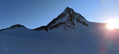
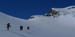
Vernagthütte is classic mountain hut in the glacier empire, high above Vent. Access to hut is not easy tour. Vernagt hut is exit point for Guslarspitze (Hochjoch Hospiz hut), Fluchtkogel, Hochvernagtspitze and the glacier Vernagtgletscher on the Wildspitz - second highest peak of Austria.
Tours starting from hut
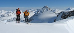
Ski tours around Hut Vernagthütte
-
Wildspitze - Vernagt Hütte to Vent 3770 m
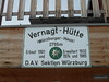
Vernagthütte Ötztal Alps / Alpi Venoste Austria
- Length of ascent7,5 km
- ascent1100 m
- duration7-9 h
- Fitness difficulty ♦♦♦◊
- Technical difficulty ♦♦♦♦
Trasa výstupu je shodná z túrou z chaty Vernagthütte. Při sjezdu odbočte doleva k sedlu Mitterkarjoch. Velký pozor na trhliny na okraji ledovce. Varianta z ledovce doleva vede strmým, vysněženým svahem. Varianta pravá, přes Mitterkarjoch poskytuje při nižší sněhové pokrývce sestup přes feratu obtížnosti B/C. Po vyjetí ze strmých svahů traverzujtedoleva s co nejmenší ztrátou výšky velkým kotlem k chatě Breslauer. Od chaty zpočátku přes strmý svah k horní stanici lanovky ze skiareálu Vent. Po sjezdovkách dolů na parkoviště. Túra jen pro zkušené alpinisty - výborné lyžaře a schopnosti lézt ve skalním terénu!

-

Guslarspitze N - Vernagthütte 3138 m
Vernagthütte Ötztal Alps / Alpi Venoste Austria
- Length of ascent2,5 km
- ascent450 m
- duration1,5-2,5 h
- Fitness difficulty ♦◊◊◊
- Technical difficulty ♦♦◊◊
Túra na Guslarspitze je nejjednodušší v oblasti chaty Vernagthütte. Svah prudší než 3 stupňů je jen kousek pod vrcholem. Přes vrchol vede nejkratší cesta na sousední chatu Hochjoch Hospiz. Tato túra je bez vrcholové pasáže alternativou pro dny se špatným počasím.
-
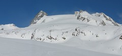
Fluchtkogel SE, from Vernagthütte 3500 m
Vernagthütte Ötztal Alps / Alpi Venoste Austria
- Length of ascent4 km
- ascent740 m
- duration3-4,5 h
- Fitness difficulty ♦♦♦◊
- Technical difficulty ♦♦◊◊
Túra na Fluchtkogel z Vernagthütte je výletem za krásnými výhledy přes celé Ötztálské Alpy. Jediný prudší úsek je pod sedle Oberes Guslarjoch a ještě v závěrečném svahu na plochý vrchol. Dolů kolem výstupových stop.
-
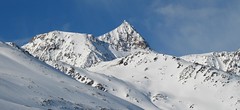
Hochvernagtspitze 3539 m
Vernagthütte Ötztal Alps / Alpi Venoste Austria
- Length of ascent5 km
- ascent790 m
- duration4-5,5 h
- Fitness difficulty ♦♦◊◊
- Technical difficulty ♦♦♦◊
Túra z chaty Vernagthütte na Hochvernagtspitze vede zajímavou ledovcovou krajinou. Po překonání prudkého ledovcového zlomu dojdete k východnímu okraji skalnatého hřebene. Odložíte lyže a pomocí maček a cepínu po hřebeni střídavě nahoru a dolů na vrchol. Pozor při nestabilní konzistenci sněhu! Sjezd po trase výstupu.
-

Wildspitze W - Vernagt Hütte 3770 m
Vernagthütte Ötztal Alps / Alpi Venoste Austria
- Length of ascent7,5 km
- ascent1100 m
- duration5,5-7 h
- Fitness difficulty ♦♦♦◊
- Technical difficulty ♦♦♦◊
Výstup na Wildspize, nejvyšší horu Tyrolska je nejjednodušší z horské chaty Vernagt Hütte. Je to náročná, poměrně dlouhá ledovcová túra. Nejobtížnějším místem je výstup do sedla Brochkogeljoch (pozor na lavinu). Většinou je nutné nasadit mačky. Následuje dlouhá ledovcová pláň a pak prudší výstup na závěrečné plató. Na jeho okraji odložte lyže (skidepot) a v mačkách a s cepínem po hřebeni k vrcholovému kříži. Pozor na převěje při větším množství sněhu.
- Country
- Austria
- Montains
- Ötztal Alps / Alpi Venoste
- Open (winter)
- March - mid May
- Beds
- 90
- Winterraum
- 29
- Shortening of access (cableway, lift, taxi, snowcat...)
- no
- Luggage transport
- no
- Card Pay
- no
- Shower
- yes
- Wifi
- no
- UTM / CH1903 x ("longitude" E/W)
- 32 T 639043
- UTM / CH1903 y ("latitude" N/S)
- 5190513
- GPX access to hut (waipoints, track)
- VernagtH_Vent_access_skitour.gpx
- GPX access to hut (track only)
- VernagtH access_TRK.gpx
- GPX all tours from the hut
- VernagtH_ALL_skitours.gpx
- Map
- Wildspitze, OEAV 1:25000, Nr. 30/6 Weisskugel, OEAV 1:25000, Nr. 30/2
- Guides
- Ötztal – Silvretta / Bergverlag Rother, deusch SCHITOUREN-ATLAS ÖSTERREICH WEST / Schall Verlag, deusch Skitourenführer Ötztaler Alpen / Panico, deusch
- Phone (hut)
- +43(0)664/1412119
- Phone (valley)
- +43 (0)720 920315
- Cell phone
- 0043/5254/8128
- Mobile Signal
- yes
- Web
- vernagthuette.de
- info@wieshof.at
- Owner of hut
- DAV Sektion Würzburg
- Vernagthütte 2.755m
- Reservation
- online form
- Online reservation
- alpsonline.org
- Start Point
- Vent
- UTM / CH1903 x ("longitude" E/W)
- 32 T 645899
- UTM / CH1903 y ("latitude" N/S)
- 5191358
- Altitude
- 1885 m
- Ascent (height difference)
- 890 m
- Time of Access
- 3-4 h
- Shortening lift
- no
- Avalanche danger
- lawine.at
- Weather
- Vernagthütte / meteoblue.com Vernagthuette / yr.no Bergwetter Tirol 2 days Vent, snow-forecast.com Hochvernagtspitze 3539 / mountain-forecast.com Wildspitze 3772 / mountain-forecast.com Guslarspitzen 3147 / mountain-forecast.com Fluchtkogel 3500 / mountain-forecast.com Fluchtkogel / meteoblue.com Hint. Brochkogel 3625m / mountain-forecast.com Alpenvereinswetter wetter.at - Austria ZAMG - Austria ORF Wetter
- Snow report
- Vent / bergfex.at Vent / snow-forecast.com Sölden / schneeradar.de Sölden / onthesnow.com
- Webcams
- Vernagthütte Vent Rif. Bella Vista / Schöne Aussicht Hütte Sölden-Rettenbachgletscher
- Region
- Vent Ötztal
- Public traffic
- Postbus
- Skiresort nearby
- Sölden
- Other links
- Austria Tourism
hut Vernagthütte - Reviews
There are no reviews in this section yet. Click the Add Review button to add first review.
Best ski tours in mountains Ötztal Alps / Alpi Venoste, Austria
-
Finailspitze North (from Hochjoch Hospiz) 3514 m
Hochjoch Hospiz Ötztal Alps / Alpi Venoste Austria
- Length of ascent7 km
- ascent1390 m
- duration5,5-7 h
- Fitness difficulty ♦♦♦◊
- Technical difficulty ♦♦♦◊
The tour to Fineilspitze begins with a short descent from the Hochjoch Hospiz hut into the valley of the Rofenache stream. Cross the stream and ascend on the right-hand side above the gorge. After the valley widens, continue left up over a moraine onto the glacier. On the glacier, head right of the ridge to a point at 3447 m. Leave the skis there and continue without them, using crampons, over exposed terrain along the ridge to the summit. Descent follows the ascent route.
-

Mittlerer Seelenkogel 3426 m
Langtalereckhütte Ötztal Alps / Alpi Venoste Austria
- Length of ascent5 km
- ascent1000 m
- duration4-5,5 h
- Fitness difficulty ♦♦◊◊
- Technical difficulty ♦♦♦◊
Mittlerer Seelenkogel (Langtalereck Hütte, Ötztaler Alpen) is a rather difficult skitour for his second half. Traverse in steep terrain and the finish can be done under good conditions only.
-
Schalfkogel E (Langtalereck H.) 3537 m
Langtalereckhütte Ötztal Alps / Alpi Venoste Austria
- Length of ascent7 km
- ascent1500 m
- duration5,5-7 h
- Fitness difficulty ♦♦♦◊
- Technical difficulty ♦♦♦◊
Schalfkogel (Langtalereck Hütte, Ötztaler Alpen) is a relatively demanding tour. After climbing the glacier Gurgler Ferner is a challenging steep steep part of the glacier Kleinleiten Ferner. From the saddle Schalfkogeljoch longer and harder ascent without skis. The mountain is also accessible from Martin Busch Hütte.
Best ski tours in Austria by skitour.guru
-

Nockberge Trail Day 2 2336 m
Innerkrems - Mehrlhütte Nockberge Austria
- Length of ascent10,5 km
- ascent1210 m
- duration6-8 h
- Fitness difficulty ♦♦♦◊
- Technical difficulty ♦♦♦◊
2. etapa 4denního skialpového přechodu Nockberge Trail vede z Innerkremsu na Turracher Höhe a je ze všech nejnáročnější - jak délkou, převýšenm tak i technickou náročností. Oblé kopce alpského pohoří Nockberge mají jedinou nevýhodu - vítr z jejich svahů často odfoukne sníh a je ho místy nedostatek. Po bezproblémovém výstupu na Königstuhl a Karlnock následuje sjezd do sedla Stangnock a pak po širokém hřebenu nahoru na Gregerlnock. Následující sjezd poměrně prudkým svahem má lavinový potenciál - buďte pozorní, v případě špatných podmínek sjíždějte po hřebenu do míst, kde je svah mírnější. Po sjezdu na alm následuje orientačně zapeklitá fáze - držte se striktně linie v GPS. Za potokem začíná výstup na Winkler Alm. Cesta na sjezdovku nevede přes les (pozor na stopy). Až dorazíte k sjezdovce, musíte ještě vystoupat k lanovce Schafalmbahn (na dohled) a po sjezdovce č.1 na sedlo Turracher Höhe.
-

Östliche Seespitze 3416 m
Franz Senn Hütte Stubai Alps Austria
- Length of ascent6,5 km
- ascent1270 m
- duration6-8 h
- Fitness difficulty ♦♦♦◊
- Technical difficulty ♦♦♦◊
Östliche Seespitze (Franz Senn Hütte, Stubaier Alpen) is a glacier tour with a steep passage (30-35°). At the end without skiing along the ridge to the summit.
-

Dreiländerspitze NW (Wiesbadener H.) 3197 m
Wiesbadener Hütte Silvretta Austria
- Length of ascent3,5 km
- ascent750 m
- duration4-5,5 h
- Fitness difficulty ♦♦♦◊
- Technical difficulty ♦♦♦♦
The ski tour to peak Dreiländerspitze is initially unpretentious. Climb from Wiesbadener Hut to the Ochsenscharte. Further unpleasant traverse to the rocky ridge. Skidepo - fitting crampons and ice axe, ascent alternately on both sides of the ridge to the top. There are several climbing steps just before the summit. Back along the ascent route.