
 Česky
Česky Deutsch


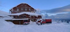

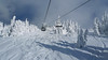


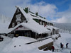

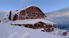


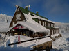
The two huts - Dvoračky and Štumpovka are next to each other and have one owner. The location of the holiday home under the ridge, not far from the cable car to Lysá hora, is an excellent starting point for ski tours to the Giant Mountains ridge. The easiest access is from Rokytnice nad Jizerou by cable car to Lysá hora and from there a short descent to the mountain hut.
Tours starting from hut
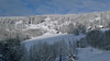
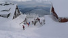
Ski tours around Hut Rokytnice n.J. - Dvoračky
-

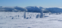
Vlčí hřeben 1130 m
Rokytnice n.J. - Dvoračky Giant Mountains Czech
- Length of ascent6,5 km
- ascent380 m
- duration2,5-4,5 h
- Fitness difficulty ♦◊◊◊
- Technical difficulty ♦◊◊◊
Velice lehký okruh pro absolutní začátečníky, ideální pro malé děti. V polovině trasy nabízí občerstvení Hotel Rezek.

-
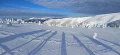
Kotel - Rokytnice nad Jizerou 1435 m
Rokytnice n.J. - Dvoračky Giant Mountains Czech
- Length of ascent8 km
- ascent730 m
- duration3-4,5 h
- Fitness difficulty ♦◊◊◊
- Technical difficulty ♦◊◊◊
Okruh po hřebenech Krakonoš nad Rokytnicí je nejlépe dostupný z horského hotelu Dvoračky - Štumpovka. Okruh začíná sjezdem na Lovčenku a pak na pásech 400 výškových metrů. Další orientační bod je Zadní Plech. Následuje dlouhý výstup na hřeben, odkud je možná odbočka na Labskou boudu. Po hřebenové cestě kolem oblého vrcholu Kotel a Lysou horou na Dvoračky.
- Country
- Czech
- Montains
- Giant Mountains
- Open (winter)
- daily
- Beds
- 141
- Winterraum
- no
- Shortening of access (cableway, lift, taxi, snowcat...)
- by cableway, from Rokytnice to Lysá hora
- Luggage transport
- yes
- Shower
- yes
- Wifi
- yes
- UTM / CH1903 x ("longitude" E/W)
- 33U 536098
- UTM / CH1903 y ("latitude" N/S)
- 5621858
- GPX all tours from the hut
- Dvoracky-Rokytnice_all_WPT_TRK.gpx
- Map
- Krkonoše západ, zimní mapa 1:25 000, ROSY
- Phone (hut)
- +420 720 983 033
- Phone (valley)
- -
- Cell phone
- -
- Mobile Signal
- yes
- Web
- dvoracky.cz
- info@dvoracky.cz
- Owner of hut
- privat
- Dvoračky Štumpovka
- Reservation
- online form
- Online reservation
- https://www.dvoracky.cz/
- Avalanche danger
- horskasluzba.cz
- Weather
- Rokytnice, ventusky.com Lysá hora 1344m, meteoblue.com Rokytnice, horskasluzba.cz Zadní Plech 1210m, meteoblue.com Rokytnice, in-pocasi.cz Rokytnice, meteoskop.cz Rokytnice, ceskehory.cz ČHMU - model Aladin Rokytnice, snow-forecast.com
- Snow report
- Rokytnice, snow-forecast.com Rokytnice, snow.cz Rokytnice, onthesnow.com Rokytnice, bergfex.com
- Webcams
- Rokytnice.com bergfex.com holidayinfo.cz
- Region
- krkonose.eu rokytnice.com - tourist information Czech Tourism - Kudy z nudy
- Public traffic
- České dráhy - train IDOS - timetables
- Skiresort nearby
- Rokytnice nad Jizerou
hut Rokytnice n.J. - Dvoračky - Reviews
There are no reviews in this section yet. Click the Add Review button to add first review.
Best ski tours in mountains Giant Mountains, Czech
-
Krkonoše haute route, day 4 1360 m
Děčínská bouda - Růžohorky Giant Mountains Czech
- Length of ascent5 km
- ascent620 m
- duration4-5,5 h
- Fitness difficulty ♦◊◊◊
- Technical difficulty ♦♦◊◊
The last, 4th day of the Krkonoše Haute Route begins with a short ascent to Růžová hora. This is followed by a freeride under the rope to Pec pod Sněžkou. From the lower station of the Pec-Sněžka cable car up around the mountain hut Richtrovy Boudy to Výrovka. The last descent through the Dlouhý důl valley to Špindlerův Mlýn.
-

Modrý důl 1375 m
Bouda pod Sněžkou Giant Mountains Czech
- Length of ascent5,5 km
- ascent600 m
- duration3-5 h
- Fitness difficulty ♦◊◊◊
- Technical difficulty ♦◊◊◊
The ascent from Pec pod Snezkou to Výrovka via Richtrovy boudy and then the descent through the Modrý dul valley back to Pec pod Sněžkou.
-
Krkonoše haute route, day 2 1510 m
Brádlerovy boudy Giant Mountains Czech
- Length of ascent17 km
- ascent1470 m
- duration6-9 h
- Fitness difficulty ♦♦♦◊
- Technical difficulty ♦◊◊◊
On the second day of the Giant Mountains Haute route. The route leads from Martinovka or Brádlerovy boudy to the ridge and via Špindlerova bouda and the summit of Malý Šišák to Luční bouda. Then over the ridge to Výrovka and then descends through the Modrý důl valley to Pec pod Sněžkou. Overnight in the Bouda pod Sněžkou mountain hut.
Best ski tours in Czech by skitour.guru
-

Olešnice - Polomský kopec - Šerlich 1052 m
Masarykova chata - Šerlich - Deštné Orlicke hory Czech
- Length of ascent10 km
- ascent915 m
- duration4,5-5,5 h
- Fitness difficulty ♦♦◊◊
- Technical difficulty ♦◊◊◊
Z Olešnice v Orlických horách vedou lesní cesty přes občasné paseky a zbytky hraničního opevnění na Polomský vrch na Šerlišský Mlýn. Odtud je možné přidat malý okruh přes Černý kříž opět na Šerlišský Mlýn a odtud na Masarykovu chatu, případně do nedalekéjho silničního sedla Šerlich. Tato trasa může být prvním dnem víkendového putování přes Orlické hory od západu na východ.
-
Rozhledna Miloňová 846 m
Javorníky - Valašsko Javorníky - Valašsko Czech
- Length of ascent6 km
- ascent440 m
- duration2,5-4 h
- Fitness difficulty ♦◊◊◊
- Technical difficulty ♦◊◊◊
Trasa začíná na parkovišti u Hotelu Galík. Případně u Ski areálu Razula. Odtud se vydáme po modré turistické značce k parkovišti Malá Hanzlůvka. Zde se otočíme téměř o 180 stupňů doleva a vydáme se po červené cyklotrase po cestě zvané Škaredica na rozcestí Nad Lanternou. Zde pokračujeme vpravo po značce vedoucí k rozhledně Miloňová. Z Miloňové po svážnicových cestách doleva zpět na trasu cykotrasy, kde se začneme vracet k místu startu. U rozcestí Nad Lanternou pak můžeme sundat z lyží pásy a vydat se po bývalé sjezdovce sjezdem zpět k autu.
-

Ještěd - trasa Úvozem 1012 m
Ještěd - Jizerské hory Jizera Mountains Czech
- Length of ascent3 km
- ascent425 m
- duration h
- Fitness difficulty ♦◊◊◊
- Technical difficulty ♦◊◊◊
Trasa zvaná Úvozem začíná u spodní stanice lanovky na Ještěd a klikatí se po východních svazích Jestědu na vrchol. Návrat do Liberce po sjezdovkách. Značení tras pro fitness skitouring na Ještědu zajišťují chlapi z Horské služby a finační podpory značení se ujala firma Nalehko.com.