
 Česky
Česky Deutsch


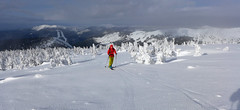


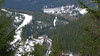


The ski tour begins in the Svatý Petr ski resort at the lower station of the Pláně cable car. A simple gradual ascent interrupts the crossing of the Stoh ski slope. Crampons can be useful on the icy surface of the steep north slope. Soon a couple of switchbacks and possibly a short descent to Bouda Klínovka. Chalupa na Rozcestí and Výrovka offer further refreshment options. A descent leads from Výrovka through the Dlouhý důl valley to Špindlerův Mlýn.
Peak
- Country
- Czech
- Montains
- Giant Mountains
- Tags
- Czech Republic české hory Krkonoše Špindlerův Mlýn
- Hut
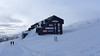
- Chata Výrovka
- Other Huts
- Špindlerův Mlýn
- UTM / CH1903 x ("longitude" E/W)
- 33U 548210
- UTM / CH1903 y ("latitude" N/S)
- 5618399
Start point
- Start Point
- Chata Výrovka
- Altitude
- 1356 m
- UTM / CH1903 x ("longitude" E/W)
- 33U 548012
- UTM / CH1903 y ("latitude" N/S)
- 5618432
Conditions
- Avalanche danger
- horskasluzba.cz
- Weather
- Pec pod Sněžkou, ventusky.com Sněžka 1602 m, meteoblue.com Sněžka 1602 m, mountain-forecast.com Pec pod Sněžkou, horskasluzba.cz Pec pod Sněžkou, in-pocasi.cz Pec pod Sněžkou, meteoskop.cz Pec pod Sněžkou, ceskehory.cz ČHMU - model Aladin Pec pod Sněžkou, snow-forecast.com Pec pod Sněžkou, snow.cz
- Snow report
- Pec pod Sněžkou, snow-forecast.com Pec pod Sněžkou, snow.cz Pec pod Sněžkou, onthesnow.com Pec pod Sněžkou, bergfex.com
- Webcams
- Chata Výrovka Pec pod Sněžkou, bergfex.com Pec pod Sněžkou, holidayinfo.cz
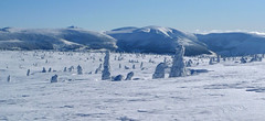
Ski tour map on Dlouhý důl


 bivakovací nouzová chata
  cepín a mačky potřeba
 exponovaný, obtížný terén
 horská chata
 hôtel, penzion
 lanovka, vlek
 lavinové nebezpečí, svah > 30°
 ledovcové trhliny
 lehká túra
 mimořádně obtížná túra
 mírně obtížná túra
 obtížná túra
 parkoviště
 přístup k chatě
 restaurace
 sedlo
sedlo sjezd
sjezd skidepo
 vrchol
 výstup
 začátek ledovce
- bivouac, winter room
- crampons & ice axe necessary
- exposed, difficulty terrain
- mountain hut, refuge
- hotel, pension
- cableway, skilift
- avalanche danger, slope > 30°
- glacier cracks
- little difficult tour
- extremely difficult tour
- rather difficult tour
- difficult tour
- parking
- hut acces
- restaurant
- col, pass, saddle
- descent
- skidepot
- peak, summit
- ascent
- glacier beginning
- biwak, winterraum
- steigeisen & pickel erforderlich
- ausgesetzt, schwierige gelände
- berghütte
- hotel, pension
- seilbahn, skilift
- lawinengefahr, hangneigung > 30°
- gletscherspalten
- wenig schwierige tour
- äusserst schwierige tour
- ziemlich schwierige tour
- schwierige tour
- parkplatz
- zugang zur hütte
- restaurant
- sattel, joch, pass
- abfahrt
- skidepot
- gipfel
- aufsieg
- gletscher anfang
- bivacco, locale invernale
- ramponi & piccozza necessari
- esposto, terreno difficolt?
- rifugio, capanna
- alberghi, pensione
- funivia, seggiovia
- pericolo di valanghe, pendenza > 30°
- crepe glacier
- tour piccolo difficile
- tour estremamente difficile
- tour piuttosto difficile
- escursioni difficili
- parcheggio
- accesso capanna
- ristorante
- col, sella, passo, forcella
- discesa
- sci deposito
- picco, vertice, piz
- salita
- inizio ghiacciaio
- bivouac, local d'hiver
- crampons & piolet nécessaire
- exposée, difficulté du terrain
- cabane de montagne, refuge
- hôtel, pension
- téléphérique, téléski
- danger d'avalanche, pente > 30°
- crevasse du glacier
- peu difficile tour
- extr?mement difficile tournée
- assez difficile tour
- difficile tournée
- parking
- acces cabane
- restaurant
- col, selle
- descente
- skis dépôt
- pic, sommet
- ascension
- début glacier
- < 20°
- 20° - 25°
- 25° - 30°
- 30° - 35°
- 35° - 40°
- > 40°
Current weather conditions in the tour area
Planning of ski tour
- Fitness difficulty
-
- ♦♦◊◊
- Technical difficulty
-
- ♦◊◊◊
- best time for this tour
- all winter
- Glacier
- No
- Map
- Krkonoše střed, zimní mapa 1:25 000, ROSY Krkonoše západ, zimní mapa 1:25 000, ROSY
About Ski tour
- Time difficulty
- Ascent (height difference)
- 840 m
- Lenght of ascent
- 9 km
- Descent (height difference)
- 840 m
- Total Lenght of tour
- 16 km
- Total time of the tour
- 3-5 h
- Elevation Range
- 760 - 1360 m
- Principal Aspect
- W, N, NW S-south, N-north, W-west, E-east
Download
- GPX (track only)
- Dlouhy-Dul_TRK.gpx best for display on a detailed topographical map (mapy.cz) or in apps for smartphones (Locus, Garmin Connect, etc.)
- GPX (waipoints, track)
- DlouhyDul_Spindl_Skitour.gpx great for uploading in GPS device
- KML (with POI)
- Dlouhy-dul_Spindl_skitour.kml for viewing in the Google Earth 3D map application, which you can install on your PC
tour Dlouhý důl - Reviews
There are no reviews in this section yet. Click the Add Review button to add first review.
Best ski tours in Giant Mountains by skitour.guru
-
Krkonoše haute route, day 3 1603 m
Bouda pod Sněžkou Giant Mountains Czech
- Length of ascent4 km
- ascent800 m
- duration3-4,5 h
- Fitness difficulty ♦♦◊◊
- Technical difficulty ♦♦◊◊
Sněžka je nejvyšší česká hora. Nejzajímavější trasa vede z Obřího dolu od Boudy pod Sněžkou. Lze podniknout okružní túru se sjezdem podél lanovky Pec - Sněžka k mezistanici Růžová hora. O něco níže je dvojice horských chat - Děčínská bouda a Růžohorky. Zde končí 3. etapa Krkonošské haute route.

-
Krkonoše haute route, day 2 1510 m
Brádlerovy boudy Giant Mountains Czech
- Length of ascent17 km
- ascent1470 m
- duration6-9 h
- Fitness difficulty ♦♦♦◊
- Technical difficulty ♦◊◊◊
On the second day of the Giant Mountains Haute route. The route leads from Martinovka or Brádlerovy boudy to the ridge and via Špindlerova bouda and the summit of Malý Šišák to Luční bouda. Then over the ridge to Výrovka and then descends through the Modrý důl valley to Pec pod Sněžkou. Overnight in the Bouda pod Sněžkou mountain hut.
-
Kotel - Rokytnice nad Jizerou 1435 m
Rokytnice n.J. - Dvoračky Giant Mountains Czech
- Length of ascent8 km
- ascent730 m
- duration3-4,5 h
- Fitness difficulty ♦◊◊◊
- Technical difficulty ♦◊◊◊
Okruh po hřebenech Krakonoš nad Rokytnicí je nejlépe dostupný z horského hotelu Dvoračky - Štumpovka. Okruh začíná sjezdem na Lovčenku a pak na pásech 400 výškových metrů. Další orientační bod je Zadní Plech. Následuje dlouhý výstup na hřeben, odkud je možná odbočka na Labskou boudu. Po hřebenové cestě kolem oblého vrcholu Kotel a Lysou horou na Dvoračky.