
 Česky
Česky Deutsch


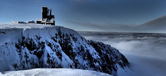


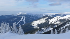
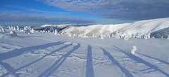
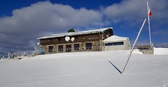
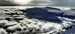
On the second day of the Giant Mountains Haute route. The route leads from Martinovka or Brádlerovy boudy to the ridge and via Špindlerova bouda and the summit of Malý Šišák to Luční bouda. Then over the ridge to Výrovka and then descends through the Modrý důl valley to Pec pod Sněžkou. Overnight in the Bouda pod Sněžkou mountain hut.
Peak
- Country
- Czech
- Montains
- Giant Mountains
- Tags
- Czech Republic české hory Haute Route Krkonoše Špindlerův Mlýn
- Hut
- Brádlerovy boudy
- Other Huts
- Martinova bouda
- UTM / CH1903 x ("longitude" E/W)
- 33U 548995
- UTM / CH1903 y ("latitude" N/S)
- 5619607
Start point
- Start Point
- Brádlerovy boudy
- Altitude
- 1156 m
- UTM / CH1903 x ("longitude" E/W)
- 33U 541263
- UTM / CH1903 y ("latitude" N/S)
- 5624114
- cableway / lift
- yes, Špindlerův Mlýn - Medvědín
- Participed on tour mapping
- Vojtěch Dvořák, mountain guide UIAGM, alphaguide.cz, www.alphaguide.cz
Conditions
- Avalanche danger
- horskasluzba.cz
- Weather
- Špindlerův Mlýn, ventusky.com Ptačí kámen 1213 m, meteoblue.com Vysoké Kolo 1508 m, mountain-forecast.com Špindlerův Mlýn, horskasluzba.cz Špindlerův Mlýn, in-pocasi.cz Špindlerův Mlýn, meteoskop.cz Špindlerův Mlýn - Svatý Petr, ceskehory.cz ČHMU - model Aladin Špindlerův Mlýn, snow-forecast.com
- Snow report
- Špindlerův Mlýn, snow-forecast.com Špindlerův Mlýn, snow.cz Špindlerův Mlýn, onthesnow.com Špindlerův Mlýn, bergfex.com
- Webcams
- bradlerovy-boudy.cz Medvědín, holidayinfo.cz Svatý Petr, ceskehory.cz Svatý Petr, holidayinfo.cz Svatý Petr, bergfex.com Medvědín, bergfex.com
Ski tour map on Krkonoše haute route, day 2


 bivakovací nouzová chata
  cepín a mačky potřeba
 exponovaný, obtížný terén
 horská chata
 hôtel, penzion
 lanovka, vlek
 lavinové nebezpečí, svah > 30°
 ledovcové trhliny
 lehká túra
 mimořádně obtížná túra
 mírně obtížná túra
 obtížná túra
 parkoviště
 přístup k chatě
 restaurace
 sedlo
sedlo sjezd
sjezd skidepo
 vrchol
 výstup
 začátek ledovce
- bivouac, winter room
- crampons & ice axe necessary
- exposed, difficulty terrain
- mountain hut, refuge
- hotel, pension
- cableway, skilift
- avalanche danger, slope > 30°
- glacier cracks
- little difficult tour
- extremely difficult tour
- rather difficult tour
- difficult tour
- parking
- hut acces
- restaurant
- col, pass, saddle
- descent
- skidepot
- peak, summit
- ascent
- glacier beginning
- biwak, winterraum
- steigeisen & pickel erforderlich
- ausgesetzt, schwierige gelände
- berghütte
- hotel, pension
- seilbahn, skilift
- lawinengefahr, hangneigung > 30°
- gletscherspalten
- wenig schwierige tour
- äusserst schwierige tour
- ziemlich schwierige tour
- schwierige tour
- parkplatz
- zugang zur hütte
- restaurant
- sattel, joch, pass
- abfahrt
- skidepot
- gipfel
- aufsieg
- gletscher anfang
- bivacco, locale invernale
- ramponi & piccozza necessari
- esposto, terreno difficolt?
- rifugio, capanna
- alberghi, pensione
- funivia, seggiovia
- pericolo di valanghe, pendenza > 30°
- crepe glacier
- tour piccolo difficile
- tour estremamente difficile
- tour piuttosto difficile
- escursioni difficili
- parcheggio
- accesso capanna
- ristorante
- col, sella, passo, forcella
- discesa
- sci deposito
- picco, vertice, piz
- salita
- inizio ghiacciaio
- bivouac, local d'hiver
- crampons & piolet nécessaire
- exposée, difficulté du terrain
- cabane de montagne, refuge
- hôtel, pension
- téléphérique, téléski
- danger d'avalanche, pente > 30°
- crevasse du glacier
- peu difficile tour
- extr?mement difficile tournée
- assez difficile tour
- difficile tournée
- parking
- acces cabane
- restaurant
- col, selle
- descente
- skis dépôt
- pic, sommet
- ascension
- début glacier
- < 20°
- 20° - 25°
- 25° - 30°
- 30° - 35°
- 35° - 40°
- > 40°
Current weather conditions in the tour area
Planning of ski tour
- Fitness difficulty
-
- ♦♦♦◊
- Technical difficulty
-
- ♦◊◊◊
- best time for this tour
- all winter
- Glacier
- No
- Map
- Krkonoše západ, zimní mapa 1:25 000, ROSY
About Ski tour
- Time difficulty
- Ascent (height difference)
- 1470 m
- Lenght of ascent
- 17 km
- Descent (height difference)
- 1035 m
- Total Lenght of tour
- 24 km
- Total time of the tour
- 6-9 h
- Elevation Range
- 750 - 1510 m
- Principal Aspect
- S, SE, W, SW S-south, N-north, W-west, E-east
Download
- GPX (track only)
- Krkonoše HR_2d_TRK.gpx best for display on a detailed topographical map (mapy.cz) or in apps for smartphones (Locus, Garmin Connect, etc.)
- GPX (waipoints, track)
- Krkonose_HR_2day_skitour.gpx great for uploading in GPS device
- KML (with POI)
- Krkonose-haute-route_2d_skitour.kml for viewing in the Google Earth 3D map application, which you can install on your PC
Video of tour on Krkonoše haute route, day 2
tour Krkonoše haute route, day 2 - Reviews
There are no reviews in this section yet. Click the Add Review button to add first review.
Ski tours around Hut Brádlerovy boudy, in mountains Giant Mountains, Czech
-
Vysoké kolo - Wielki Szyszak 1509 m
Brádlerovy boudy Giant Mountains Czech
- Length of ascent3 km
- ascent360 m
- duration1,5-2,5 h
- Fitness difficulty ♦◊◊◊
- Technical difficulty ♦◊◊◊
A popular destination on the ridge of Giant Mountains is the peak of Vysoké kolo (High Wheel), the fourth highest mountain in the Giant Mountains. A relatively easily accessible peak from Brádlerovy boudy or Martinova bouda or from the valley of Spindleruv Mlyn.

-
Labský důl - circuit 1358 m
Brádlerovy boudy Giant Mountains Czech
- Length of ascent6,5 km
- ascent585 m
- duration3,5-5 h
- Fitness difficulty ♦◊◊◊
- Technical difficulty ♦◊◊◊
A round trip around the huts above Špindlerův Mlýn. The route begins with a descent from Bradlerovy boudy and goes into the Labsjý důl valley. The ascent to Labská bouda and about 1 km behind the hut begins the descent to Martinova bouda and then to the Brádlerovy boudy. Possible to combine with the ascent to Vysoké kolo. Another variant is the ridge route from Labská bouda via Vysoké kolo - see the Krkonoše-haute route day1 ski tour.
Best ski tours in Giant Mountains by skitour.guru
-
Krkonoše haute route, day 4 1360 m
Děčínská bouda - Růžohorky Giant Mountains Czech
- Length of ascent5 km
- ascent620 m
- duration4-5,5 h
- Fitness difficulty ♦◊◊◊
- Technical difficulty ♦♦◊◊
The last, 4th day of the Krkonoše Haute Route begins with a short ascent to Růžová hora. This is followed by a freeride under the rope to Pec pod Sněžkou. From the lower station of the Pec-Sněžka cable car up around the mountain hut Richtrovy Boudy to Výrovka. The last descent through the Dlouhý důl valley to Špindlerův Mlýn.
-
Zlaté Návrší - Vrbatova bouda 1400 m
Špindlerův Mlýn Giant Mountains Czech
- Length of ascent8 km
- ascent665 m
- duration3-4 h
- Fitness difficulty ♦◊◊◊
- Technical difficulty ♦◊◊◊
Easy ski tour to Vrbatovo návrší, which offers a beautiful view of the surrounding ridges of the Giant Mountains. Not far above the popular mountain hut is the monument of Hanč and Vrbata, who died in 1913 during cross-country skiing race. The ascent begins in the parking lot of the cable car to Medvědín and along the edges of the ski slope and the connecting paths to the top of the Medvědín ski slopes. From here along a flat ridge to Vrbatova bouda and Vrbatovo návrší.
-
Krkonoše haute route, day 3 1603 m
Bouda pod Sněžkou Giant Mountains Czech
- Length of ascent4 km
- ascent800 m
- duration3-4,5 h
- Fitness difficulty ♦♦◊◊
- Technical difficulty ♦♦◊◊
Sněžka je nejvyšší česká hora. Nejzajímavější trasa vede z Obřího dolu od Boudy pod Sněžkou. Lze podniknout okružní túru se sjezdem podél lanovky Pec - Sněžka k mezistanici Růžová hora. O něco níže je dvojice horských chat - Děčínská bouda a Růžohorky. Zde končí 3. etapa Krkonošské haute route.