
 Česky
Česky Deutsch


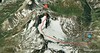


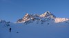
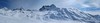
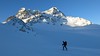


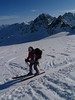


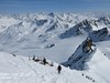

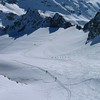


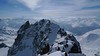
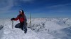


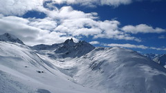
Piz Kesch is a well-known mountain in the Albula Alps region, Piz Kesch clearly falls on the surrounding mountains. The view of Kesch can be enjoyed from Bernina, Muragl and other peaks. The ascent to the ski depot is easy. You go on / climb with an ice axe and crampons. The exposed terrain in places, the difficulty depends on the current snow conditions. Rope protection is usually not necessary. A perfect panoramic view from above.
Peak
- Country
- Switzerland
- Montains
- Albula Alps
- Tags
- Albula Alps Albula Alps Alps3000 Engadin Graubünden Haute Route Graubünden Schweiz St. Moritz Switzerland
- Hut
- Keschhütte / Chamanna digl Kesch
- Other Huts
- Chamanna Es-cha / Es-cha Hütte
- UTM / CH1903 x ("longitude" E/W)
- 786411
- UTM / CH1903 y ("latitude" N/S)
- 166229
Start point
- Start Point
- Keschhütte / Chamanna digl Kesch
- Altitude
- 2627 m
- UTM / CH1903 x ("longitude" E/W)
- 786510
- UTM / CH1903 y ("latitude" N/S)
- 168893
- cableway / lift
- no
Conditions
- Avalanche danger
- slf.ch - Institut für Schnee- und Lawinenforschung
- Weather
- Keschhütte / meteodata Kesch Pitschen 2804m / srf.ch Bergün / snow-forecast.com Piz Kesch 3418m / mountain-forecast.com Piz Forun 3052m / mountain-forecast.com Piz Val Müra 3162m / mountain-forecast.com Chüealphorn 3078m/ mountain-forecast.com Piz Kesch / meteoblue.com Gletscher Ducan 3020m/ mountain-forecast.com Vadret da Porschabella 2847m / meteoblue.com Bergün / wetter.com Switzerland - animation / srf.ch Alpenvereinswetter
- Snow report
- Bergün-Filisur / snow-forecast.com Bergün-Filisur / onthesnow.com Bergün-Filisur / bergfex.ch Bergün-Filisur / snow.myswitzerland.com
- Webcams
- Bergün Bergün - Alp Darflux Zuoz - skiresort
Ski tour map on Piz Kesch - Chamanna Kesch


 bivakovací nouzová chata
  cepín a mačky potřeba
 exponovaný, obtížný terén
 horská chata
 hôtel, penzion
 lanovka, vlek
 lavinové nebezpečí, svah > 30°
 ledovcové trhliny
 lehká túra
 mimořádně obtížná túra
 mírně obtížná túra
 obtížná túra
 parkoviště
 přístup k chatě
 restaurace
 sedlo
sedlo sjezd
sjezd skidepo
 vrchol
 výstup
 začátek ledovce
- bivouac, winter room
- crampons & ice axe necessary
- exposed, difficulty terrain
- mountain hut, refuge
- hotel, pension
- cableway, skilift
- avalanche danger, slope > 30°
- glacier cracks
- little difficult tour
- extremely difficult tour
- rather difficult tour
- difficult tour
- parking
- hut acces
- restaurant
- col, pass, saddle
- descent
- skidepot
- peak, summit
- ascent
- glacier beginning
- biwak, winterraum
- steigeisen & pickel erforderlich
- ausgesetzt, schwierige gelände
- berghütte
- hotel, pension
- seilbahn, skilift
- lawinengefahr, hangneigung > 30°
- gletscherspalten
- wenig schwierige tour
- äusserst schwierige tour
- ziemlich schwierige tour
- schwierige tour
- parkplatz
- zugang zur hütte
- restaurant
- sattel, joch, pass
- abfahrt
- skidepot
- gipfel
- aufsieg
- gletscher anfang
- bivacco, locale invernale
- ramponi & piccozza necessari
- esposto, terreno difficolt?
- rifugio, capanna
- alberghi, pensione
- funivia, seggiovia
- pericolo di valanghe, pendenza > 30°
- crepe glacier
- tour piccolo difficile
- tour estremamente difficile
- tour piuttosto difficile
- escursioni difficili
- parcheggio
- accesso capanna
- ristorante
- col, sella, passo, forcella
- discesa
- sci deposito
- picco, vertice, piz
- salita
- inizio ghiacciaio
- bivouac, local d'hiver
- crampons & piolet nécessaire
- exposée, difficulté du terrain
- cabane de montagne, refuge
- hôtel, pension
- téléphérique, téléski
- danger d'avalanche, pente > 30°
- crevasse du glacier
- peu difficile tour
- extr?mement difficile tournée
- assez difficile tour
- difficile tournée
- parking
- acces cabane
- restaurant
- col, selle
- descente
- skis dépôt
- pic, sommet
- ascension
- début glacier
- < 20°
- 20° - 25°
- 25° - 30°
- 30° - 35°
- 35° - 40°
- > 40°
Current weather conditions in the tour area
Planning of ski tour
- Fitness difficulty
-
- ♦♦◊◊
- Technical difficulty
-
- ♦♦♦◊
- best time for this tour
- March-April
- Glacier
- Yes
- Map
- 1237 Albulapass, Swisstopo 1:25000 1236 Savognin, Swisstopo 1:25000 S258 Bergün-Bravuogn, Swisstopo 1:50000
- Guides
- Graubünden Süd / SAC-CAS.ch, deutsch Die klassischen Skitouren / SAC-CAS.ch, deutsch Les classiques de randonnée à ski / SAC-CAS.ch, francais
- find current conditions and experiences on the spot
- gipfelbuch.ch
About Ski tour
- Time difficulty
- Ascent (height difference)
- 845 m
- Lenght of ascent
- 4,5 km
- Descent (height difference)
- 845 m
- Total Lenght of tour
- 9 km
- Total time of the tour
- 4,5-6 h
- Elevation Range
- 2627 - 3417 m
- Principal Aspect
- N, E S-south, N-north, W-west, E-east
Download
- GPX (track only)
- Piz-Kesch_Keschhuette_TRK.gpx best for display on a detailed topographical map (mapy.cz) or in apps for smartphones (Locus, Garmin Connect, etc.)
- GPX (waipoints, track)
- Piz-Kesch_Kesch-Hut_skitour.gpx great for uploading in GPS device
- KML (with POI)
- Piz-Kesch_3418_Keschhut_skitour.kml for viewing in the Google Earth 3D map application, which you can install on your PC
Video of tour on Piz Kesch - Chamanna Kesch
Current avalanche potential on tour - Piz Kesch - Chamanna Kesch

tour Piz Kesch - Chamanna Kesch - Reviews
There are no reviews in this section yet. Click the Add Review button to add first review.
Best ski tours in Albula Alps by skitour.guru
-
Piz Muragl 3156 m
Muottas Muragl - Romantik Hotel Albula Alps Switzerland
- Length of ascent6 km
- ascent780 m
- duration4,5,5 h
- Fitness difficulty ♦♦◊◊
- Technical difficulty ♦♦◊◊
Piz Muragl je dokonalá vyhlídková hora. Výstup ulehčí zubačka na Muottas Muragl a příjemný sjezd dovede lyžaře na parkoviště u vláčku. Perfektní výhledy na velikány masivu Bernina i kaskádu jezer kolem St. Moritz. Technicky nenáročná túra.

-

Isenfürggli 2765 m
Davos Albula Alps Switzerland
- Length of ascent3 km
- ascent845 m
- duration2,5-3,5 h
- Fitness difficulty ♦♦◊◊
- Technical difficulty ♦♦◊◊
The ascent to the Isenfürggli saddle is a worthwhile addition after successful descents from Pischahorn or Isentällispitz. Especially in firn conditions or fresh powder, it is a rewarding destination. From the saddle, there is a beautiful view of the Silvretta range, with the striking Piz Linard as its centerpiece.
-

Gletscher Ducan 3019 m
Davos Albula Alps Switzerland
- Length of ascent6,5 km
- ascent1360 m
- duration5,5-7 h
- Fitness difficulty ♦♦◊◊
- Technical difficulty ♦♦♦◊
The Ducan Gletscher is a summit with a wonderful view of the Piz Kesch and especially the Piz Ela. The ski tour starts in Monstein, where the highest brewery in Europe is located. The Fanezfurgga saddle leads to valley with a striking mountain. The end of the climb up is usually with ice axe and crampons. The descent through the Ducantal valley is oriented to the north and leads skiers into the Sertigtal valley. The route can also be done in the opposite direction. It is advisable to undertake the tour with the support of public transport.