
 Česky
Česky Deutsch


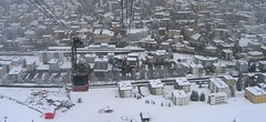


Davos is a world-famous winter sports resort and a famous air spa with the typical flat roofs. The main area suitable for ski tours is between the freeride Resort Pischa and the Flüela Pass - peaks Flüela Wisshorn, Isentällispitze and Pischahorn. South of Davos is the village of Monstein with the highest brewery in Europe and the possibility of other ski tours, mainly Ducan Gletscher.
Tours starting from hut
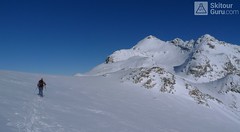
Ski tours around Hut Davos
-
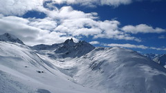
Flüela Wisshorn 3085 m
Davos Albula Alps Switzerland
- Length of ascent6,5 km
- ascent1360 m
- duration5,5-7 h
- Fitness difficulty ♦♦◊◊
- Technical difficulty ♦♦♦◊
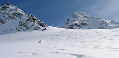
Flüela Wisshorn is the most interesting ski tour around Davos. It is offered to do an interesting round with two great downhills. The north slope to the Jöriseen lakes promises powder, while the south slopes to the Flüelatal valley promise firn. The ascent is not very demanding, at the end to the summit without skis with the help of crampons, then down to Jöriseen and noc once in the nameless saddle. Finally departure to the Flüelatal. Attention, in 2019 there was a landslide of stones in the area of the ascent route, which therefore changes the ascent route.

-

Weissfluh - Chörbhorn - Schatzalp 2845 m
Davos Albula Alps Switzerland
- Length of ascent1,5 km
- ascent430 m
- duration3-4 h
- Fitness difficulty ♦♦◊◊
- Technical difficulty ♦♦◊◊
Interesting freetouring that takes advantage of the opportunity to take the cable car from the Parsenn area to almost 3000 meters in altitude. After descending along the southeastern line of Weissfluh, an easy freeride follows in the direction of Strelapass. The difficulty is influenced by the passability of the gallery – see photo. With a short ascent to the summit of Chörbhorn, you gain space for a descent through pristine snow. Then, you continue via the piste to the Schatzalp cog railway station and further down the toboggan run to Davos, where a bus or train is available.
-

Gletscher Ducan 3019 m
Davos Albula Alps Switzerland
- Length of ascent6,5 km
- ascent1360 m
- duration5,5-7 h
- Fitness difficulty ♦♦◊◊
- Technical difficulty ♦♦♦◊
The Ducan Gletscher is a summit with a wonderful view of the Piz Kesch and especially the Piz Ela. The ski tour starts in Monstein, where the highest brewery in Europe is located. The Fanezfurgga saddle leads to valley with a striking mountain. The end of the climb up is usually with ice axe and crampons. The descent through the Ducantal valley is oriented to the north and leads skiers into the Sertigtal valley. The route can also be done in the opposite direction. It is advisable to undertake the tour with the support of public transport.
-

Isenfürggli 2765 m
Davos Albula Alps Switzerland
- Length of ascent3 km
- ascent845 m
- duration2,5-3,5 h
- Fitness difficulty ♦♦◊◊
- Technical difficulty ♦♦◊◊
The ascent to the Isenfürggli saddle is a worthwhile addition after successful descents from Pischahorn or Isentällispitz. Especially in firn conditions or fresh powder, it is a rewarding destination. From the saddle, there is a beautiful view of the Silvretta range, with the striking Piz Linard as its centerpiece.
-

Pischahorn 2980 m
Davos Albula Alps Switzerland
- Length of ascent1,5-2 km
- ascent585 m
- duration3-4 h
- Fitness difficulty ♦♦◊◊
- Technical difficulty ♦♦◊◊
Pohodová túra na Pischahorn s krásným výhledem na údolí Davosu. S podporou lanovky je to na vrchol pouhých 500 výškových metrů. Sjezd má díky šířce svahu mnoho variant.
-

Isentällispitz 2985 m
Davos Albula Alps Switzerland
- Length of ascent4 km
- ascent1050 m
- duration3-4,5 h
- Fitness difficulty ♦♦◊◊
- Technical difficulty ♦♦◊◊
Isentällispitz is another enjoyable ski tour starting in the Flüelatal valley. From the Tschuggen parking lot, ascend over wide slopes to the saddle, where the ski depot is located. From there, continue with crampons to the panoramic summit. The descent follows the ascent route.
- Country
- Switzerland
- Montains
- Albula Alps
- Open (winter)
- Beds
- 0
- Winterraum
- Shortening of access (cableway, lift, taxi, snowcat...)
- UTM / CH1903 x ("longitude" E/W)
- 782653
- UTM / CH1903 y ("latitude" N/S)
- 185926
- GPX all tours from the hut
- Davos_ALL_WPT_TRK_wo_icons.gpx
- Map
- 1197 Davos, Swisstopo 1:25000 S258 Bergün-Bravuogn, Swisstopo 1:50000
- Guides
- Graubünden Süd / SAC-CAS.ch, deutsch Die klassischen Skitouren / SAC-CAS.ch, deutsch Les classiques de randonnée à ski / SAC-CAS.ch, francais Rund um Davos / Rother, deutsch
- find current conditions and experiences on the spot
- gipfelbuch.ch
- Phone (hut)
- -
- Phone (valley)
- -
- Cell phone
- -
- Web
- davos.ch
- info@davos.ch
- Owner of hut
- -
- Davos Klosters
- Reservation
- online form
- Online reservation
- davos.ch
- Avalanche danger
- slf.ch - Institut für Schnee- und Lawinenforschung
- Weather
- Davos / snow-forecast.com Davos / srf.ch Flüela Wisshorn / mountain-forecast.com Pischahorn 2979m / mountain-forecast.com Weissfluh 2843m / mountain-forecast.com Chüpfenflue 2658m/ mountain-forecast.com Pischahorn 3980m/ meteoblue.com Gletscher Ducan 3020m/ mountain-forecast.com Davos / wetter.com Switzerland - animation / srf.ch Flüelapass / srf.ch
- Snow report
- Davos / snow-forecast.com Davos / onthesnow.com Davos - Pischa / bergfex.ch Davos / snow.myswitzerland.com
- Webcams
- Jakobshorn - Davos Strelapass Weissfluhjoch Davos - 17 webcams
- Region
- Graubünden Monstein Monsteiner Bier Bergführer Davos
- Public traffic
- SBB Railway Postauto.ch - bus Davos - regional buses
- Skiresort nearby
- Davos Pischa Schatzalp Jakobshorn
- Other links
- Switzerland Tourism SLF Davos - Institute for Snow and Avalanche Research
hut Davos - Reviews
There are no reviews in this section yet. Click the Add Review button to add first review.
Best ski tours in mountains Albula Alps, Switzerland
-
Piz Muragl 3156 m
Muottas Muragl - Romantik Hotel Albula Alps Switzerland
- Length of ascent6 km
- ascent780 m
- duration4,5,5 h
- Fitness difficulty ♦♦◊◊
- Technical difficulty ♦♦◊◊
Piz Muragl je dokonalá vyhlídková hora. Výstup ulehčí zubačka na Muottas Muragl a příjemný sjezd dovede lyžaře na parkoviště u vláčku. Perfektní výhledy na velikány masivu Bernina i kaskádu jezer kolem St. Moritz. Technicky nenáročná túra.
-

Piz d´Err 3378 m
Chamanna Jenatsch / Jenatschhütte Albula Alps Switzerland
- Length of ascent km
- ascent m
- duration h
- Fitness difficulty ♦♦◊◊
- Technical difficulty ♦♦◊◊
Piz d´Err is a popular ski tour to the panoramic summit. The technically undemanding ski tour begins in Chamanna Jenatsch. The only steep section is climbing on the summit. A first class experience is under stable conditions the descent to the opposite side, western slopes to Surselva, more precisely to the village Sur, a total of 1,800 m.
-
Piz Calderas 3397 m
Chamanna Jenatsch / Jenatschhütte Albula Alps Switzerland
- Length of ascent km
- ascent745 m
- duration2,5-4 h
- Fitness difficulty ♦♦◊◊
- Technical difficulty ♦♦♦◊
Piz Calderas is a popular peak above Chamanna Jenatsch. From the valley above the hut turn left onto the northern slope of the glacier Vadret Calderas. Followed by travers to the glacial mulch and at the end of the southeast slope to the top. Downhill along the exit route.
Best ski tours in Switzerland by skitour.guru
-

Blanc de Moming - Dôme Circuit 3649 m
Cabane du Mountet Walliser Alpen / Alpes valaisannes Switzerland
- Length of ascent10 km
- ascent2035 m
- duration9-11 h
- Fitness difficulty ♦♦♦♦
- Technical difficulty ♦♦♦♦
Blanc de Moming - Dôme is a beautiful but also very demanding complex ski tour. First ascent from Cabane Mountet to La Forcle saddle and then not very easy descent and then ascent along the Glacier du Besso. At the end of the glacier there is an uncomfortable border between snow and rock. Climb a rocky slope. First along a flat ridge, which is increasingly exposed. It is recommended to belay in windy weather. At the beginning of the spectacular descent along the Glacier de Moming, pay attention to the gigantic cracks. The departure line (keep left) turns from the northern to the western slope. After reaching the valley there is an easy ascent along the Glacier de Zinal back to Cabane Mountet.
-

Breithorn - Zermatt 4164 m
Monte Rosa Hütte Walliser Alpen / Alpes valaisannes Switzerland
- Length of ascent3 km
- ascent440 m
- duration3-4 h
- Fitness difficulty ♦♦♦◊
- Technical difficulty ♦♦♦◊
Breithorn can be rated as the lightest 4000 in the Alps. In any case, thanks to the support of the Klein Matterhorn cable car, which transports ski mountaineers up to 3880 m. From the cable car station (beautiful viewpoint) to the glacier plain below the summit, which can be often reached on skis. In good conditions, it is worthwhile to continue to the Schwarztor saddle and drive descent back to Zermatt. The second variant of the freeride is the descent from the Unterer Theodulgletscher. This descent is simply great up to Seehöre 2400.
-

Bishorn 4153 m
Cabane Tracuit Walliser Alpen / Alpes valaisannes Switzerland
- Length of ascent4,5 km
- ascent950 m
- duration5-6,5 h
- Fitness difficulty ♦♦♦◊
- Technical difficulty ♦♦◊◊
Bishorn seems to be a relatively light 4000, but looks are deceptive. If you include the approach to Cabane Tracuit from Zinal in the ascent, it is quite a long ski tour. From the hut the ascent line leads slightly up the glacier Turtmanngletscher. Directly below the peak on the plateau you have to swap skis for crampons and comfortably climb to the panoramic summit - one of the best in all of Valais. Driving down the northern slope is usually a fantastic enjoyment, the risk of glacier cracks is minimal.