
 Česky
Česky Deutsch


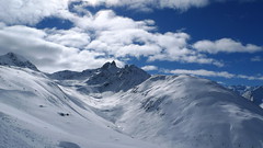
The Chamanna Grialetsch / Grialetsch hut near the Flüela Pass can also be reached from Davos and Zernez. In addition, the last hut of the multi-day crossing - the Haute Route Graubünden. From the Grialetschhütte you can climb up to the Piz Sarsura, Piz Grialetsch, Scalettahorn, Piz Radönt or Schwarzhorn.
Tours starting from hut
Ski tours around Hut Grialetschhütte / Chamanna Grialetsch

- Country
- Switzerland
- Montains
- Albula Alps
- Open (winter)
- end February - mid April
- Beds
- 61
- Winterraum
- open, 20 beds
- Shortening of access (cableway, lift, taxi, snowcat...)
- no
- Luggage transport
- no
- Card Pay
- no
- Shower
- no
- Wifi
- no
- UTM / CH1903 x ("longitude" E/W)
- 792820
- UTM / CH1903 y ("latitude" N/S)
- 176315
- GPX access to hut (waipoints, track)
- Grialetsch-Hut_all_access.gpx
- GPX access to hut (track only)
- GrialetschHut_all_access_TRK.gpx
- Map
- 1237 Albulapass, Swisstopo 1:25000 1236 Savognin, Swisstopo 1:25000 S258 Bergün-Bravuogn, Swisstopo 1:50000
- Guides
- Graubünden Süd / SAC-CAS.ch, deutsch Die klassischen Skitouren / SAC-CAS.ch, deutsch Les classiques de randonnée à ski / SAC-CAS.ch, francais
- find current conditions and experiences on the spot
- gipfelbuch.ch
- Phone (hut)
- +41 81 416 34 36
- Phone (valley)
- -
- Cell phone
- +41 79 280 26 83
- Mobile Signal
- no
- Web
- grialetsch.ch
- reissc@bluewin.ch
- Owner of hut
- SAC Davos
- Reservation
- phone, e-mail
- Start Point
- Teufi - Val Dischma
- UTM / CH1903 x ("longitude" E/W)
- 786559
- UTM / CH1903 y ("latitude" N/S)
- 183063
- Altitude
- 1700 m
- Ascent (height difference)
- 900 m
- Time of Access
- 4-5 h
- Shortening lift
- no
- Avalanche danger
- slf.ch - Institut für Schnee- und Lawinenforschung
- Weather
- Keschhütte / meteodata Davos / snow-forecast.com Zuoz / snow-forecast.com Schwarzhorn 3147m / mountain-forecast.com Piz Vadret 3221m / mountain-forecast.com Piz Sarsura 3178m / mountain-forecast.com Chüealphorn 3078m/ mountain-forecast.com Piz Grialetsch 3130m/ meteoblue.com Gletscher Ducan 3020m/ mountain-forecast.com Davos / wetter.com Switzerland - animation / srf.ch Alpenvereinswetter
- Snow report
- Davos / snow-forecast.com Davos / onthesnow.com Davos - Pischa / bergfex.ch Zernez / snow.myswitzerland.com
- Webcams
- Jakobshorn - Davos Zuoz - skiresort
- Region
- Graubünden Engadin Bergün Davos Haute Route Graubünden Naturpark Ela
- Public traffic
- SBB Railway Postauto.ch - bus
- Skiresort nearby
- Davos Zuoz
- Other links
- Switzerland Tourism
hut Grialetschhütte / Chamanna Grialetsch - Reviews
There are no reviews in this section yet. Click the Add Review button to add first review.
Best ski tours in mountains Albula Alps, Switzerland
-

Gletscher Ducan 3019 m
Davos Albula Alps Switzerland
- Length of ascent6,5 km
- ascent1360 m
- duration5,5-7 h
- Fitness difficulty ♦♦◊◊
- Technical difficulty ♦♦♦◊
The Ducan Gletscher is a summit with a wonderful view of the Piz Kesch and especially the Piz Ela. The ski tour starts in Monstein, where the highest brewery in Europe is located. The Fanezfurgga saddle leads to valley with a striking mountain. The end of the climb up is usually with ice axe and crampons. The descent through the Ducantal valley is oriented to the north and leads skiers into the Sertigtal valley. The route can also be done in the opposite direction. It is advisable to undertake the tour with the support of public transport.

-

Piz Kesch - Chamanna Kesch 3417 m
Keschhütte / Chamanna digl Kesch Albula Alps Switzerland
- Length of ascent4,5 km
- ascent845 m
- duration4,5-6 h
- Fitness difficulty ♦♦◊◊
- Technical difficulty ♦♦♦◊
Piz Kesch is a well-known mountain in the Albula Alps region, Piz Kesch clearly falls on the surrounding mountains. The view of Kesch can be enjoyed from Bernina, Muragl and other peaks. The ascent to the ski depot is easy. You go on / climb with an ice axe and crampons. The exposed terrain in places, the difficulty depends on the current snow conditions. Rope protection is usually not necessary. A perfect panoramic view from above.
-
Piz Muragl 3156 m
Muottas Muragl - Romantik Hotel Albula Alps Switzerland
- Length of ascent6 km
- ascent780 m
- duration4,5,5 h
- Fitness difficulty ♦♦◊◊
- Technical difficulty ♦♦◊◊
Piz Muragl je dokonalá vyhlídková hora. Výstup ulehčí zubačka na Muottas Muragl a příjemný sjezd dovede lyžaře na parkoviště u vláčku. Perfektní výhledy na velikány masivu Bernina i kaskádu jezer kolem St. Moritz. Technicky nenáročná túra.
Best ski tours in Switzerland by skitour.guru
-

Tödi 3614 m
Fridolinshütte Glarus Alps Switzerland
- Length of ascent6 km
- ascent1495 m
- duration7-10 h
- Fitness difficulty ♦♦♦◊
- Technical difficulty ♦♦♦♦
In the Middle Ages, Tödi was considered the highest mountain in the world. Today it is an attractive destination for ski mountaineers, but it is not easy to hit good weather. The ascent is made difficult by a glacier littered with fractures and cracks. Starts from the Fridolins hut over the moraine and descends briefly to the Bifertenfirn glacier. The hardest part is to overcome the first two drops, then the climb up is relatively easy. Depending on the conditions on skis or with crampons to the summit. Provides information about the current conditions on the glacier in the Fridolinshütte.
-

Sustenhorn (day 1, h.r. Swiss Glacier) 3503 m
Tierberglihütte Urner Alps Switzerland
- Length of ascent4,4 km
- ascent1640 m
- duration6-8 h
- Fitness difficulty ♦♦♦◊
- Technical difficulty ♦♦◊◊
A very popular tour of glacial terrain. Start at Hotel Steingletscher (Sustenpass road, parking) or Tierbergli hütte. From the parking a large elevation of 1700 m. Technically not very demanding tour, but conditionally yes. Route parameters are listed at the start of the Hotel Steingletscher and from the peak of Sustenhorn leads downhill to Tierbergli.
-

Tour du Ciel - day 2 3404 m
Schönbielhütte Walliser Alpen / Alpes valaisannes Switzerland
- Length of ascent5 km
- ascent1190 m
- duration5-7 h
- Fitness difficulty ♦♦♦◊
- Technical difficulty ♦♦♦◊
Tour du Ciel (known as the reverse direction of the Haute Route Impériale) begins with the first real stage from the Schönbiel Hut, featuring a descent along the edge of the moraine. This is followed by a long, steep climb over glacier seracs, ideally tackled in the early morning. The subsequent ascent over the Hohlwäng Glacier to the Col Durand (3404 m) is then straightforward. An alternative is to turn right before the pass and climb Mont Durand. From the pass, descend over the Glacier Durand, followed by a short climb to the Cabane Mountet.