
 Česky
Česky Deutsch


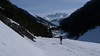
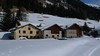
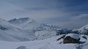
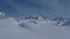

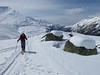


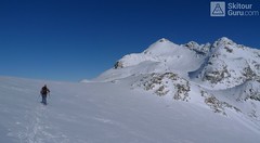
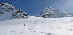
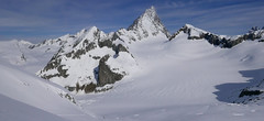
Keschhütte / Chamanna digl Kesch, together with the nearby Chalet Es-cha Hütte, is a base before climbing the dominant peak of the Albula Alps - Piz Kesch. Other summits are Kesch Pischen and Piz Porschabella. The Kesch hut is accessible from several directions. The easiest approach is from Davos and Bergün, where you can shorten thanks to the cable car (Piz Darlux). The cable car also helps with the way from Zuoz. Keschhütte is located on the popular Haute Route Graubünden.
Tours starting from hut
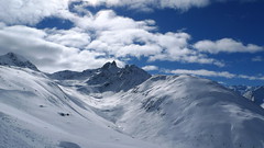
Ski tours around Hut Keschhütte / Chamanna digl Kesch

- Country
- Switzerland
- Montains
- Albula Alps
- Open (winter)
- mid Februar - mid April
- Beds
- 92
- Winterraum
- yes, 20 beds
- Shortening of access (cableway, lift, taxi, snowcat...)
- no
- Luggage transport
- no
- Card Pay
- no
- Shower
- yes
- Wifi
- no
- UTM / CH1903 x ("longitude" E/W)
- 786510
- UTM / CH1903 y ("latitude" N/S)
- 168893
- GPX access to hut (waipoints, track)
- Kesch-Hut_all_access.gpx
- GPX access to hut (track only)
- KeschHut-all-access.gpx
- Map
- 1237 Albulapass, Swisstopo 1:25000 1236 Savognin, Swisstopo 1:25000 S258 Bergün-Bravuogn, Swisstopo 1:50000
- Guides
- Graubünden Süd / SAC-CAS.ch, deutsch Die klassischen Skitouren / SAC-CAS.ch, deutsch Les classiques de randonnée à ski / SAC-CAS.ch, francais
- find current conditions and experiences on the spot
- gipfelbuch.ch
- Phone (hut)
- +41 81 407 11 34
- Phone (valley)
- -
- Cell phone
- +41 79 235 00 57
- Mobile Signal
- no
- Web
- kesch.ch
- kesch@kesch.ch
- Owner of hut
- SAC Davos
- Reservation
- online former
- Online reservation
- alpsonline.org
- Start Point
- Sertig - Sand
- UTM / CH1903 x ("longitude" E/W)
- 784283
- UTM / CH1903 y ("latitude" N/S)
- 177189
- Altitude
- 1858 m
- Ascent (height difference)
- 1170 m
- Time of Access
- 4,5-5,5 h
- Shortening lift
- no
- Start Point
- Bergün, via Val Tuors
- UTM / CH1903 x ("longitude" E/W)
- 776720
- UTM / CH1903 y ("latitude" N/S)
- 167032
- Altitude
- 1364 m
- Ascent (height difference)
- 1400 m
- Time of Access
- 4,5-5,5 h
- Shortening lift
- no
- Start Point
- Bergün- Alp Darlux (caution, often avalanche danger)
- UTM / CH1903 x ("longitude" E/W)
- 780459
- UTM / CH1903 y ("latitude" N/S)
- 166430
- Altitude
- 2282 m
- Ascent (height difference)
- 820 m
- Time of Access
- 5-6 h
- Shortening lift
- yes, skilifts from Bergün to Piz Darlux
- Start Point
- Zuoz - Som Muntatsch (skilift)
- UTM / CH1903 x ("longitude" E/W)
- 791110
- UTM / CH1903 y ("latitude" N/S)
- 165199
- Altitude
- 2460 m
- Ascent (height difference)
- 820 m
- Time of Access
- 3,5-4,5 h
- Shortening lift
- yes, from Zuoz to Som Muntatsch (upper station)
- Avalanche danger
- slf.ch - Institut für Schnee- und Lawinenforschung
- Weather
- Keschhütte / meteodata Kesch Pitschen 2804m / srf.ch Bergün / snow-forecast.com Piz Kesch 3418m / mountain-forecast.com Piz Forun 3052m / mountain-forecast.com Piz Val Müra 3162m / mountain-forecast.com Chüealphorn 3078m/ mountain-forecast.com Piz Kesch / meteoblue.com Gletscher Ducan 3020m/ mountain-forecast.com Vadret da Porschabella 2847m / meteoblue.com Bergün / wetter.com Switzerland - animation / srf.ch Alpenvereinswetter
- Snow report
- Bergün-Filisur / snow-forecast.com Bergün-Filisur / onthesnow.com Bergün-Filisur / bergfex.ch Bergün-Filisur / snow.myswitzerland.com
- Webcams
- Bergün Bergün - Alp Darflux Zuoz - skiresort
- Region
- Graubünden Engadin Bergün Davos St. Moritz Haute Route Graubünden
- Public traffic
- SBB Railway Postauto.ch - bus
- Skiresort nearby
- Bergün Davos St. Moritz - Corviglia - Corvatsch - Diavolezza
- Other links
- Switzerland Tourism
hut Keschhütte / Chamanna digl Kesch - Reviews
There are no reviews in this section yet. Click the Add Review button to add first review.
Best ski tours in mountains Albula Alps, Switzerland
-
Piz Muragl 3156 m
Muottas Muragl - Romantik Hotel Albula Alps Switzerland
- Length of ascent6 km
- ascent780 m
- duration4,5,5 h
- Fitness difficulty ♦♦◊◊
- Technical difficulty ♦♦◊◊
Piz Muragl je dokonalá vyhlídková hora. Výstup ulehčí zubačka na Muottas Muragl a příjemný sjezd dovede lyžaře na parkoviště u vláčku. Perfektní výhledy na velikány masivu Bernina i kaskádu jezer kolem St. Moritz. Technicky nenáročná túra.

-
Piz Calderas 3397 m
Chamanna Jenatsch / Jenatschhütte Albula Alps Switzerland
- Length of ascent km
- ascent745 m
- duration2,5-4 h
- Fitness difficulty ♦♦◊◊
- Technical difficulty ♦♦♦◊
Piz Calderas is a popular peak above Chamanna Jenatsch. From the valley above the hut turn left onto the northern slope of the glacier Vadret Calderas. Followed by travers to the glacial mulch and at the end of the southeast slope to the top. Downhill along the exit route.
-
Flüela Wisshorn 3085 m
Davos Albula Alps Switzerland
- Length of ascent6,5 km
- ascent1360 m
- duration5,5-7 h
- Fitness difficulty ♦♦◊◊
- Technical difficulty ♦♦♦◊
Flüela Wisshorn is the most interesting ski tour around Davos. It is offered to do an interesting round with two great downhills. The north slope to the Jöriseen lakes promises powder, while the south slopes to the Flüelatal valley promise firn. The ascent is not very demanding, at the end to the summit without skis with the help of crampons, then down to Jöriseen and noc once in the nameless saddle. Finally departure to the Flüelatal. Attention, in 2019 there was a landslide of stones in the area of the ascent route, which therefore changes the ascent route.
Best ski tours in Switzerland by skitour.guru
-

Pizzi dei Rossi 3026 m
Fornohütte - Capanna del Forno Bernina Alps Switzerland
- Length of ascent3 km
- ascent665 m
- duration4,5-6 h
- Fitness difficulty ♦♦◊◊
- Technical difficulty ♦♦♦♦
Skialpová Pizzi dei Rossi je ideální volbou pro poslední den na chatě. Návrat na parkoviště pod Malojapassem má úplně jinou úroveň, než přesun údolím. Výstup z chaty vede často traverzy zápaního svahu, na jaře jsou haršajsny nutností. Náročný je až výstup prudkým svahem do sedla, většinou bude nutné nasadit mačky a lyže dát batoh. Ze sedla nalehko a bez lyží na vrchol. Sjezd severním kuloárem je zprvu velmi prudký a bmusí se projet zúžením mezi skalami. Dál po pláních je už luxusní svah a když je dobrý sníh, je to fantastický sjezd. Ten pokračuje i údolím Val Muretto až na planinu Canis. Pár krátkých protisvahů na kraj soutěsky a pak už zase jen dolů k mostu přes horskou bystřinu a po rovině na parkoviště.
-
Vorderes Galmihorn 3507 m
Oberaarjochhütte Berner Alpen / Alpes bernoises Switzerland
- Length of ascent2,5 km
- ascent760 m
- duration4,5-6,5 h
- Fitness difficulty ♦♦◊◊
- Technical difficulty ♦♦♦◊
Vorderes Galmihorn je skvělý skialpový vrchol na závěr akce v centru Bernských Alp. Po výstupu na vrchol z chaty Oberaletschhütte přináší skvělou možnost sjezdu do údolí Goms, což je logisticky výhodné v případě startu lanovkou z Fiesch. Výstup vede po mírném ledovci Galmigletscher a dále po přehledném svahu posetém trhlinami. Při sjezdu dávejte pozor na trhlinu pod sedlem Bächlilicke. Na jaře vás v závěru túry nemine pochod do údolí s lyžemi na batohu. Nabízí se sjezd do Reckingenu nebo Münsteru.
-

Gross Wannenhorn 3905 m
Finsteraarhornhütte Berner Alpen / Alpes bernoises Switzerland
- Length of ascent6,5 km
- ascent1310 m
- duration5,5-7,5 h
- Fitness difficulty ♦♦♦◊
- Technical difficulty ♦♦♦◊
The top of the Gross Wannenhorn is a first-class lookout tower on the largest alpine glacier, the Aletsch glacier and the many 4,000-meter peaks in the Bernese Alps. After a short descent from the Finsteraarhorn Hut over the glacier Fieschergletscher at the foot of the Wannenhorn. During the ascent along a wide slope, watch out for numerous and large crevasses. Finally, the ascent line turns westwards upwards. When driving downhill, copy the exit route and pay attention to crevasses again.