
 Česky
Česky Deutsch


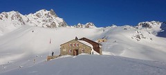


The Chamanna Es-cha / Es-cha hut is a refuge, along with the nearby Kesch hut, before you ascend the dominant peak of the Albula Alps - Piz Kesch. It is possible to climb Piz Belvair or to make the Viroula round from Zuoz. The Es-cha hut is accessible from Madulain and Zuoz. Additionally, the Haute Route Graubünden is popular along this route. The house was renovated and expanded in 2019.
Tours starting from hut
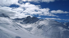
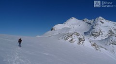
Ski tours around Hut Chamanna Es-cha / Es-cha Hütte

- Country
- Switzerland
- Montains
- Albula Alps
- Open (winter)
- mid February - end April
- Beds
- 50
- Winterraum
- yes, 20 beds
- Shortening of access (cableway, lift, taxi, snowcat...)
- no
- Luggage transport
- no
- Card Pay
- no
- Shower
- no
- Wifi
- no
- UTM / CH1903 x ("longitude" E/W)
- 786627
- UTM / CH1903 y ("latitude" N/S)
- 165131
- GPX access to hut (waipoints, track)
- Escha-Hut_access_Madulain.gpx
- GPX access to hut (track only)
- Chamanna-Escha_access_Madulain_TRK.gpx
- Map
- 1237 Albulapass, Swisstopo 1:25000 S258 Bergün-Bravuogn, Swisstopo 1:50000
- Guides
- Graubünden Süd / SAC-CAS.ch, deutsch Die klassischen Skitouren / SAC-CAS.ch, deutsch Les classiques de randonnée à ski / SAC-CAS.ch, francais
- find current conditions and experiences on the spot
- gipfelbuch.ch
- Phone (hut)
- +41 81 854 17 55
- Phone (valley)
- -
- Cell phone
- +41 79 336 25 55
- Mobile Signal
- yes, but very unstable
- Web
- es-cha.ch
- info@es-cha.ch
- Owner of hut
- CAS Bernina
- Es-cha Hütte
- Reservation
- online former
- Online reservation
- alpsonline.org
- Start Point
- Madulain
- UTM / CH1903 x ("longitude" E/W)
- 791551
- UTM / CH1903 y ("latitude" N/S)
- 162585
- Altitude
- 1685 m
- Ascent (height difference)
- 910 m
- Time of Access
- 2,5 - 3 h
- Shortening lift
- no
- Avalanche danger
- slf.ch - Institut für Schnee- und Lawinenforschung
- Weather
- Porta d´Es-cha / meteoblue.com Piz Kesch 3418m / srf.ch Zuoz / snow-forecast.com Muottas Muragl / mountain-forecast.com Piz Val Müra 3162m / mountain-forecast.com Piz Kesch 3418m/ mountain-forecast.com Porta d´Es-cha / kachelmannwetter.com Madulain / wetter.com Switzerland - animation / srf.ch Alpenvereinswetter
- Snow report
- Zuoz / snow-forecast.com Diavolezza - Pontresina / onthesnow.com Muottas Muragl / bergfex.ch Zuoz / snow.myswitzerland.com
- Webcams
- All webcams around St. Moritz Muottas Muragl Zuoz 360
- Region
- Graubünden Engadin St. Moritz Madulain Haute Route Graubünden
- Public traffic
- SBB Railway Postauto.ch - bus
- Skiresort nearby
- Zuoz St. Moritz - Corviglia - Corvatsch - Diavolezza
- Other links
- Switzerland Tourism
hut Chamanna Es-cha / Es-cha Hütte - Reviews
There are no reviews in this section yet. Click the Add Review button to add first review.
Best ski tours in mountains Albula Alps, Switzerland
-

Gletscher Ducan 3019 m
Davos Albula Alps Switzerland
- Length of ascent6,5 km
- ascent1360 m
- duration5,5-7 h
- Fitness difficulty ♦♦◊◊
- Technical difficulty ♦♦♦◊
The Ducan Gletscher is a summit with a wonderful view of the Piz Kesch and especially the Piz Ela. The ski tour starts in Monstein, where the highest brewery in Europe is located. The Fanezfurgga saddle leads to valley with a striking mountain. The end of the climb up is usually with ice axe and crampons. The descent through the Ducantal valley is oriented to the north and leads skiers into the Sertigtal valley. The route can also be done in the opposite direction. It is advisable to undertake the tour with the support of public transport.

-
Piz Muragl 3156 m
Muottas Muragl - Romantik Hotel Albula Alps Switzerland
- Length of ascent6 km
- ascent780 m
- duration4,5,5 h
- Fitness difficulty ♦♦◊◊
- Technical difficulty ♦♦◊◊
Piz Muragl je dokonalá vyhlídková hora. Výstup ulehčí zubačka na Muottas Muragl a příjemný sjezd dovede lyžaře na parkoviště u vláčku. Perfektní výhledy na velikány masivu Bernina i kaskádu jezer kolem St. Moritz. Technicky nenáročná túra.
-
Piz Calderas 3397 m
Chamanna Jenatsch / Jenatschhütte Albula Alps Switzerland
- Length of ascent km
- ascent745 m
- duration2,5-4 h
- Fitness difficulty ♦♦◊◊
- Technical difficulty ♦♦♦◊
Piz Calderas is a popular peak above Chamanna Jenatsch. From the valley above the hut turn left onto the northern slope of the glacier Vadret Calderas. Followed by travers to the glacial mulch and at the end of the southeast slope to the top. Downhill along the exit route.
Best ski tours in Switzerland by skitour.guru
-

Jungfrau 4158 m
Konkordiahütte Berner Alpen / Alpes bernoises Switzerland
- Length of ascent10 km
- ascent1510 m
- duration6,5-9 h
- Fitness difficulty ♦♦♦◊
- Technical difficulty ♦♦♦◊
Skialpová túra na Jungfrau z chaty Konkordia začíná velmi dlouhým nástupem po ledovci Jungfraufirn. Následuje prudký výstup na hřeben a dále do sedla Rottalsattel přes nepříjemnou thlinu. Skidepot a na mčkách a s cepínem po plochém hřebenu na vrchol. Alternativní sjezd přes sedlo Louwitor na ledovec Aletschfirn a po něm na chatu Konkordia. Možné je po dosažení vrcholu pokračovat na nádraží Jungfraujoch nebo nocovat na Mönchsjochhütte.
-

Alphubel 4206 m
Britannia Hütte Walliser Alpen / Alpes valaisannes Switzerland
- Length of ascent10 km
- ascent1450 m
- duration7-10 h
- Fitness difficulty ♦♦♦◊
- Technical difficulty ♦♦♦◊
ALPHUBEL (Britannia Hütte, Walliser Alpen) is seemingly lighter 4000vka, but over are dangerous glacial cracks. Ski alpinists can also go from the Saas Fee ski area, most not far from the cable car station Langfluh .
-

Tour du Ciel - day 3 3649 m
Cabane du Mountet Walliser Alpen / Alpes valaisannes Switzerland
- Length of ascent10,5 km
- ascent2420 m
- duration10-12 h
- Fitness difficulty ♦♦♦♦
- Technical difficulty ♦♦♦♦
A very long and demanding, royal stage of this Haute Route. In my opinion, the most impressive stage of all multi-day Alpine crossings. Due to the elevation gain and time required, it’s worth considering splitting the stage into two days with an overnight stay in Zinal. The long, exposed ridge to the summit requires rope protection depending on conditions. The descent is fantastically long, but caution is needed – there are large crevasses. This ski tour is only recommended in stable weather; in poor conditions, it’s advisable to bypass the Blanc de Moming via the Glacier de Zinal and ascend directly to the Cabane de Tracuit.