
 Česky
Česky Deutsch


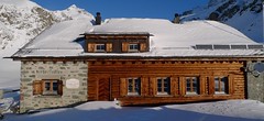


Chamanna Jenatsch is a stone mountain hut north of St. Moritz. It is accessible from Julierpass and from the top station of the Piz Nair cable car. Cozy cottage with sauna! The starting point of the ski tours to Piz Calderas, Piz Surgonda, Piz Agnel and Piz d´Err. Jenatsch Hut is overnight stay on Haute Route Graubünden. The Finnish sauna is an extraordinary enjoyment at the Jenatschhütte.
Tours starting from hut
Ski tours around Hut Chamanna Jenatsch / Jenatschhütte
-
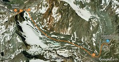
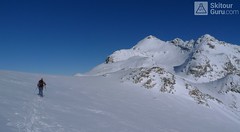
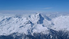
Piz d´Agnel 3205 m
Chamanna Jenatsch / Jenatschhütte Albula Alps Switzerland
- Length of ascent km
- ascent m
- duration h
- Fitness difficulty ♦♦◊◊
- Technical difficulty ♦♦◊◊

-

Piz d´Err 3378 m
Chamanna Jenatsch / Jenatschhütte Albula Alps Switzerland
- Length of ascent km
- ascent m
- duration h
- Fitness difficulty ♦♦◊◊
- Technical difficulty ♦♦◊◊
Piz d´Err is a popular ski tour to the panoramic summit. The technically undemanding ski tour begins in Chamanna Jenatsch. The only steep section is climbing on the summit. A first class experience is under stable conditions the descent to the opposite side, western slopes to Surselva, more precisely to the village Sur, a total of 1,800 m.
-

Tschima Flix 3301 m
Chamanna Jenatsch / Jenatschhütte Albula Alps Switzerland
- Length of ascent km
- ascent650 m
- duration3-4 h
- Fitness difficulty ♦♦◊◊
- Technical difficulty ♦♦◊◊
Tschima Flix is one of the light ski tours. From the Jenatsch hut through the Calderas glacier, the traverse under the Piz Picuogl wall to the glacier saddle. From there easily to the top.
-
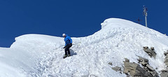
Piz Calderas 3397 m
Chamanna Jenatsch / Jenatschhütte Albula Alps Switzerland
- Length of ascent km
- ascent745 m
- duration2,5-4 h
- Fitness difficulty ♦♦◊◊
- Technical difficulty ♦♦♦◊
Piz Calderas is a popular peak above Chamanna Jenatsch. From the valley above the hut turn left onto the northern slope of the glacier Vadret Calderas. Followed by travers to the glacial mulch and at the end of the southeast slope to the top. Downhill along the exit route.
-

Piz Surgonda 3196 m
Chamanna Jenatsch / Jenatschhütte Albula Alps Switzerland
- Length of ascent km
- ascent m
- duration h
- Fitness difficulty ♦♦◊◊
- Technical difficulty ♦♦◊◊
Piz Surgonda is an easier ski tour from Jenatschhütte, or from Piz Nair upper station (Corviglia Resort, supported by the cable car) or from Julier Pass. None of the variants pose a delicate risk. And next to it stands imposing Piz Julier.
- Country
- Switzerland
- Montains
- Albula Alps
- Open (winter)
- Silvester / New Year, mid February - beginning of May
- Beds
- 75
- Winterraum
- open, 20 beds
- Shortening of access (cableway, lift, taxi, snowcat...)
- by cableway from St. Moritz - Piz Nair
- Luggage transport
- no
- Card Pay
- no
- Shower
- no
- Wifi
- no
- UTM / CH1903 x ("longitude" E/W)
- 775350
- UTM / CH1903 y ("latitude" N/S)
- 155660
- GPX access to hut (waipoints, track)
- Jenatsch-Hut_all_access_skitour.gpx
- GPX access to hut (track only)
- JenatschHut_all_access_TRK.gpx
- Map
- S268 Julierpass, Swisstopo 1:50000 1257 St. Moritz, Swisstopo 1:25000 1256 Bivio, Swisstopo 1:25000 1237 Albulapass, Swisstopo 1:25000
- Guides
- Graubünden Süd / SAC-CAS.ch, deutsch Die klassischen Skitouren / SAC-CAS.ch, deutsch Les classiques de randonnée à ski / SAC-CAS.ch, francais
- Phone (hut)
- 0041(0)81 833 29 29
- Phone (valley)
- 0041(0)78 648 01 59
- Cell phone
- -
- Mobile Signal
- yes, but unstable
- Web
- www.chamannajenatsch.ch
- info@chamannajenatsch.ch
- Owner of hut
- SAC Bernina
- Chamanna Jenatsch
- Reservation
- phone, e-mail, online
- Online reservation
- alpsonline.org
- Start Point
- Piz Nair
- UTM / CH1903 x ("longitude" E/W)
- 780281
- UTM / CH1903 y ("latitude" N/S)
- 153146
- Altitude
- 3025 m
- Ascent (height difference)
- 650 m
- Time of Access
- 2,5 - 3 h
- Shortening lift
- by cableway from St. Moritz - Corviglia - Piz Nair
- Start Point
- Julierpass
- UTM / CH1903 x ("longitude" E/W)
- 775747
- UTM / CH1903 y ("latitude" N/S)
- 149327
- Altitude
- 2287 m
- Ascent (height difference)
- 1000 m
- Time of Access
- 3-4 h
- Shortening lift
- no
- Avalanche danger
- slf.ch - Institut für Schnee- und Lawinenforschung
- Weather
- Chamanna Jenatsch / meteoblue.com Piz Jenatsch / mountain-forecast.com Tschima da Flix / mountain-forecast.com Piz Calderas 3397m / meteoblue.com Chamanna Jenatsch / srf.ch Crasta Jenatsch / kachelmannwetter.com Piz Nair / yr.no Switzerland - animation / srf.ch St. Moritz / wetter.com Alpenvereinswetter
- Snow report
- Corviglia / snow-forecast.com Corviglia / onthesnow.com Corviglia / bergfex.ch Corviglia / snow.myswitzerland.com
- Webcams
- All webcams around St. Moritz
- Region
- Haute Route Graubünden St. Moritz Engadin
- Public traffic
- SBB Railway Postauto.ch
- Skiresort nearby
- St. Moritz - Corviglia
- Other links
- Switzerland Tourism
hut Chamanna Jenatsch / Jenatschhütte - Reviews
There are no reviews in this section yet. Click the Add Review button to add first review.
Best ski tours in mountains Albula Alps, Switzerland
-

Gletscher Ducan 3019 m
Davos Albula Alps Switzerland
- Length of ascent6,5 km
- ascent1360 m
- duration5,5-7 h
- Fitness difficulty ♦♦◊◊
- Technical difficulty ♦♦♦◊
The Ducan Gletscher is a summit with a wonderful view of the Piz Kesch and especially the Piz Ela. The ski tour starts in Monstein, where the highest brewery in Europe is located. The Fanezfurgga saddle leads to valley with a striking mountain. The end of the climb up is usually with ice axe and crampons. The descent through the Ducantal valley is oriented to the north and leads skiers into the Sertigtal valley. The route can also be done in the opposite direction. It is advisable to undertake the tour with the support of public transport.
-

Isenfürggli 2765 m
Davos Albula Alps Switzerland
- Length of ascent3 km
- ascent845 m
- duration2,5-3,5 h
- Fitness difficulty ♦♦◊◊
- Technical difficulty ♦♦◊◊
The ascent to the Isenfürggli saddle is a worthwhile addition after successful descents from Pischahorn or Isentällispitz. Especially in firn conditions or fresh powder, it is a rewarding destination. From the saddle, there is a beautiful view of the Silvretta range, with the striking Piz Linard as its centerpiece.
-

Isentällispitz 2985 m
Davos Albula Alps Switzerland
- Length of ascent4 km
- ascent1050 m
- duration3-4,5 h
- Fitness difficulty ♦♦◊◊
- Technical difficulty ♦♦◊◊
Isentällispitz is another enjoyable ski tour starting in the Flüelatal valley. From the Tschuggen parking lot, ascend over wide slopes to the saddle, where the ski depot is located. From there, continue with crampons to the panoramic summit. The descent follows the ascent route.
Best ski tours in Switzerland by skitour.guru
-
Pizzo Lucendro 2963 m
Rotondohütte Urner Alps Switzerland
- Length of ascent5,5 km
- ascent1090 m
- duration4-6 h
- Fitness difficulty ♦♦◊◊
- Technical difficulty ♦♦♦◊
Pizzo Lucendro je výrazný vrchol nad Gotthardpassem a také prvotřídní rozhledna. Na túru lze vyrazit z údolního Realpu, snazší je start z chaty Rotondohütte. Po sjezdu nad úroveň salaší nastává dlouhý výstup členitým terénem, který nabírá na strmosti. Těsně pod skalním sedlem je v úzkém koridoru zvládání otočky nutností. Za sedlem následuje poměrně snadný výstup do sedla, k místu, kde bývá depo lyží. Při výstupu po hřebeni k vrcholovému kříži pozor na převěje a místy exponovaný terén. Při sjezdu za jarního firnu se vyplatí počkat v sedle, než slunce změkčí stinný svah pro velkolepý odpolední sjezd západním svahem. Z nejnižšího bodu návrat na chatu nebo sjezd až do Realpu.
-
Piz Platta 3392 m
Mulegns - Posthotel Löwen Platta Group / Oberhalbstein Switzerland
- Length of ascent11 km
- ascent1980 m
- duration8-11 h
- Fitness difficulty ♦♦♦♦
- Technical difficulty ♦♦♦◊
Impressive very long ski tour on the more pronounced Piz Platta summit in the Plattagruppe-Oberhalbstein mountain group. Aproach from the village of Mulengs - road from Tiefencastel to Julierpass. First a few kilometers through the forest, then left at the foot of the mountain and then constantly up the northeast slope to the plateau (ski depot). Next you have to climb the southern slope to the top plateau with crampons and ice axe.
-

Pigne d´Arolla 3790 m
Cabane des Dix Walliser Alpen / Alpes valaisannes Switzerland
- Length of ascent6 km
- ascent1000 m
- duration5-7,5 h
- Fitness difficulty ♦♦◊◊
- Technical difficulty ♦♦♦◊
Pigne d´Arolla is a very popular and easily accessible viewpoint. The ski tour to the summit leads from the three mountain huts - Cabane Dix, Cabane Vignettes and Cabane Chanrion. The route from Dix goes around the glacial seracs to the saddle Col de la Serpentine and the summit can be reached on skis. A worthwhile summit on the Haute Routes to Zermatt.