
 Česky
Česky Deutsch


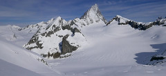

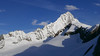

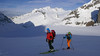


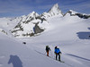
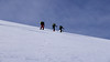

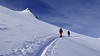

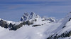


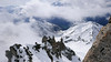


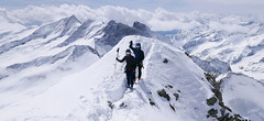
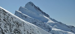
Vorderes Galmihorn je skvělý skialpový vrchol na závěr akce v centru Bernských Alp. Po výstupu na vrchol z chaty Oberaletschhütte přináší skvělou možnost sjezdu do údolí Goms, což je logisticky výhodné v případě startu lanovkou z Fiesch. Výstup vede po mírném ledovci Galmigletscher a dále po přehledném svahu posetém trhlinami. Při sjezdu dávejte pozor na trhlinu pod sedlem Bächlilicke. Na jaře vás v závěru túry nemine pochod do údolí s lyžemi na batohu. Nabízí se sjezd do Reckingenu nebo Münsteru.
Peak
- Country
- Switzerland
- Montains
- Berner Alpen / Alpes bernoises
- Tags
- Aletschgletscher Berner Alpen / Alpes bernoises Berner Oberland Bernské Alpy Fiescherfirn Finteraarhornhütte Jungfrauregion Schweiz Switzerland
- Hut
- Oberaarjochhütte
- Other Huts
- Finsteraarhornhütte
- UTM / CH1903 x ("longitude" E/W)
- 657294
- UTM / CH1903 y ("latitude" N/S)
- 150859
Start point
- Start Point
- Oberaarjochhütte
- Altitude
- 3256 m
- UTM / CH1903 x ("longitude" E/W)
- 657294
- UTM / CH1903 y ("latitude" N/S)
- 150859
- cableway / lift
- no
Conditions
- Avalanche danger
- SLF
- Weather
- Oberaarjoch, meteoblue.com Galmihorn, mountain-forecast.com Galmihorn, meteoblue.com Oberaarhorn, mountain-forecast.com Finsteraarhorn / meteoblue.com Alpenverein Wetter Switzerland / meteo.ch Switzerland - animation / srf.ch
- Snow report
- Konkordiahuette - Meteograms Goms - Obergoms / snow-forecast.com Goms / snow.myswitzerland.com Aletsch Arena / onthesnow.com Jungfrauregion / snow.myswitzerland.com
- Webcams
- Oberaarsee, Konkordiahütte
Ski tour map on Vorderes Galmihorn


 bivakovací nouzová chata
  cepín a mačky potřeba
 exponovaný, obtížný terén
 horská chata
 hôtel, penzion
 lanovka, vlek
 lavinové nebezpečí, svah > 30°
 ledovcové trhliny
 lehká túra
 mimořádně obtížná túra
 mírně obtížná túra
 obtížná túra
 parkoviště
 přístup k chatě
 restaurace
 sedlo
sedlo sjezd
sjezd skidepo
 vrchol
 výstup
 začátek ledovce
- bivouac, winter room
- crampons & ice axe necessary
- exposed, difficulty terrain
- mountain hut, refuge
- hotel, pension
- cableway, skilift
- avalanche danger, slope > 30°
- glacier cracks
- little difficult tour
- extremely difficult tour
- rather difficult tour
- difficult tour
- parking
- hut acces
- restaurant
- col, pass, saddle
- descent
- skidepot
- peak, summit
- ascent
- glacier beginning
- biwak, winterraum
- steigeisen & pickel erforderlich
- ausgesetzt, schwierige gelände
- berghütte
- hotel, pension
- seilbahn, skilift
- lawinengefahr, hangneigung > 30°
- gletscherspalten
- wenig schwierige tour
- äusserst schwierige tour
- ziemlich schwierige tour
- schwierige tour
- parkplatz
- zugang zur hütte
- restaurant
- sattel, joch, pass
- abfahrt
- skidepot
- gipfel
- aufsieg
- gletscher anfang
- bivacco, locale invernale
- ramponi & piccozza necessari
- esposto, terreno difficolt?
- rifugio, capanna
- alberghi, pensione
- funivia, seggiovia
- pericolo di valanghe, pendenza > 30°
- crepe glacier
- tour piccolo difficile
- tour estremamente difficile
- tour piuttosto difficile
- escursioni difficili
- parcheggio
- accesso capanna
- ristorante
- col, sella, passo, forcella
- discesa
- sci deposito
- picco, vertice, piz
- salita
- inizio ghiacciaio
- bivouac, local d'hiver
- crampons & piolet nécessaire
- exposée, difficulté du terrain
- cabane de montagne, refuge
- hôtel, pension
- téléphérique, téléski
- danger d'avalanche, pente > 30°
- crevasse du glacier
- peu difficile tour
- extr?mement difficile tournée
- assez difficile tour
- difficile tournée
- parking
- acces cabane
- restaurant
- col, selle
- descente
- skis dépôt
- pic, sommet
- ascension
- début glacier
- < 20°
- 20° - 25°
- 25° - 30°
- 30° - 35°
- 35° - 40°
- > 40°
Current weather conditions in the tour area
Planning of ski tour
- Fitness difficulty
-
- ♦♦◊◊
- Technical difficulty
-
- ♦♦♦◊
- best time for this tour
- March-beginning of May
- Glacier
- Yes
- Map
- Nufenenpass 265 S, Swisstopo 1:50000 Jungfrau 264 S, Swisstopo 1:50000 Ulrichen LK 1250, Swisstopo 1:25000 Jungfrau region LK 2520, Swisstopo 1:25000
- Guides
- Berner Alpen Ost, SAC Verlag Die klassischen Skitouren
About Ski tour
- Time difficulty
- Ascent (height difference)
- 760 m
- Lenght of ascent
- 2,5 km
- Descent (height difference)
- 2655 m
- Total Lenght of tour
- 15 km
- Total time of the tour
- 4,5-6,5 h
- Elevation Range
- 1365 - 3507 m
- Principal Aspect
- SE, NW S-south, N-north, W-west, E-east
Download
- GPX (track only)
- Galmihorn_OberaarjochH_TRK.gpx best for display on a detailed topographical map (mapy.cz) or in apps for smartphones (Locus, Garmin Connect, etc.)
- GPX (waipoints, track)
- Galmihorn_OberaarjochH_skitour.gpx great for uploading in GPS device
- KML (with POI)
- Galmihorn_OberaarjochHut_skitour.kml for viewing in the Google Earth 3D map application, which you can install on your PC
Current avalanche potential on tour - Vorderes Galmihorn

tour Vorderes Galmihorn - Reviews
There are no reviews in this section yet. Click the Add Review button to add first review.
Best ski tours in Berner Alpen / Alpes bernoises by skitour.guru
-

Jungfrau 4158 m
Konkordiahütte Berner Alpen / Alpes bernoises Switzerland
- Length of ascent10 km
- ascent1510 m
- duration6,5-9 h
- Fitness difficulty ♦♦♦◊
- Technical difficulty ♦♦♦◊
Skialpová túra na Jungfrau z chaty Konkordia začíná velmi dlouhým nástupem po ledovci Jungfraufirn. Následuje prudký výstup na hřeben a dále do sedla Rottalsattel přes nepříjemnou thlinu. Skidepot a na mčkách a s cepínem po plochém hřebenu na vrchol. Alternativní sjezd přes sedlo Louwitor na ledovec Aletschfirn a po něm na chatu Konkordia. Možné je po dosažení vrcholu pokračovat na nádraží Jungfraujoch nebo nocovat na Mönchsjochhütte.

-
Grosses Grünhorn 4044 m
Mönchsjochhütte Berner Alpen / Alpes bernoises Switzerland
- Length of ascent3,5 km
- ascent970 m
- duration6-8 h
- Fitness difficulty ♦♦♦◊
- Technical difficulty ♦♦♦◊
Grosses Grünhorn je jediná 4000vka v oblasti chaty Konkordiahütte. Výstup z chaty Mönchsjochhütte vede z po ledovci Ewigschneefeld a následně po severozápadních svazích na hřeben Grünhornu. Pozor na ledovcové trhliny. Nedaleko od sedla je skidepot od kterého se jde na vrchol v mačkách. Sjezd pokračuje logicky na Konkordiaplatz a túra končí na chatě Konkordia. Tak je to ideální. Alternativou je výstup sjezd přes vrchol Grünegghorn, na který se musí vylézt s lyžemi na batohu.
-
Finsteraarhorn 4374 m
Finsteraarhornhütte Berner Alpen / Alpes bernoises Switzerland
- Length of ascent3,5 km
- ascent1280 m
- duration7-9,5 h
- Fitness difficulty ♦♦♦◊
- Technical difficulty ♦♦♦♦
Na vrchol Finsteraarhorn míří náročná ledovcová túra z chaty Finsteraarhornhütte. Hned od začátku túry jsou cestou velkolepé výhledy. Náročnější je překonání skalního žebra. Po ledovci do sedla Hugisattel s leteckým pohledem na východní stěnu. Zde je skidepot a dál v mačkách a s cepínem na skialpové poměry náročným terénem. Obtížnost lezení zásadně ovlivňuje množství a konzistence sněhu na skále. Náročný sjezd prudkými svahy kopíruje linii výstupu.