
 Česky
Česky Deutsch


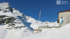


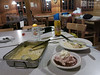


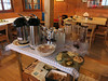
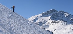
Stone, excellently furnished mountain hut in a popular climbing area. Transition point for the Swiss Glacier Haute Route. The position of the hut on the rock can complicate the safety access to the hut when avalanche situation complicate is.
Tours starting from hut
Ski tours around Hut Bächlitalhütte

- Country
- Switzerland
- Montains
- Berner Alpen / Alpes bernoises
- Open (winter)
- mid march - mid may
- Beds
- 75
- Winterraum
- open, 24 beds, cooking is posible
- Shortening of access (cableway, lift, taxi, snowcat...)
- no
- Card Pay
- no
- Shower
- no
- Wifi
- no
- UTM / CH1903 x ("longitude" E/W)
- 664 680
- UTM / CH1903 y ("latitude" N/S)
- 159 870
- GPX access to hut (waipoints, track)
- TOUR_Baechlitalhut-access.gpx
- GPX all tours from the hut
- BaechlitalHut allTOUR_WPT_SkitourGuru.gpx
- Map
- Sustenpass 255 S, Swisstopo 1:50000 Guttannen 1230, Swisstopo 1:25000
- Guides
- Skitouren Berner Alpen Ost
- Phone (hut)
- 0041 (0)33 973 11 14
- Phone (valley)
- 0041 (0) 41 495 21 30
- Cell phone
- 0041 (0) 79 614 43 69
- Mobile Signal
- no
- Web
- -
- info@baechlitalhuette.ch
- Owner of hut
- SAC Am Albis
- Start Point
- Räterichsboden
- UTM / CH1903 x ("longitude" E/W)
- 667703
- UTM / CH1903 y ("latitude" N/S)
- 160330
- Altitude
- 1710 m
- Ascent (height difference)
- 720 m
- Time of Access
- 2-2,5 h
- Shortening lift
- no
- Avalanche danger
- SLF
- Weather
- SRF Meteo Meteoschweiz snow-forecast.com - Engelberg Meteoblue - Bächlital Meteoblue - Obri Bächlilücke
- Snow report
- snow-forecast.com - Grindelwald snow-forecast.com - Melchsee-Frutt bergfex.ch - Grindelwald onthesnow.com - Grindelwald myswitzerland.com -Meiringen Hasliberg
- Webcams
- Räterichsboden Innertkirchen Guttannen Gelmersee
- Region
- Haslital Zentralschweiz Tourismus
- Public traffic
- Vlaky Linkové autobusy
- Skiresort nearby
- Grindelwald Melchsee-Frutt Andermatt - Realp
- Other links
- Guttannen Haslital Hütten
hut Bächlitalhütte - Reviews
There are no reviews in this section yet. Click the Add Review button to add first review.
Best ski tours in mountains Berner Alpen / Alpes bernoises, Switzerland
-

Äbeni Flue - Ebnerfluh 3962 m
Hollandiahütte (Lötschenhütte) Berner Alpen / Alpes bernoises Switzerland
- Length of ascent4,5 km
- ascent800 m
- duration3,5-5 h
- Fitness difficulty ♦♦◊◊
- Technical difficulty ♦♦◊◊
Relatively easy glacier ski tour to the most popular summit of the Hollandia hut. The glacier is not too cracked and the ascent path is gradually gaining altitude. At the end, ridge is waiting between the secondary and main summits. With good visibility it is a ski tour without complications.

-
Mönch 4107 m
Mönchsjochhütte Berner Alpen / Alpes bernoises Switzerland
- Length of ascent2 km
- ascent525 m
- duration2,5-4 h
- Fitness difficulty ♦♦◊◊
- Technical difficulty ♦♦♦♦
Túra na impozantní Mnich (Mönch) je v podstatě dlouhou hřebenovkou v mačkách a s cepínem. S rostoucí výškou roste obtížnost. S úbytkem ledovcového příkrovu roste expozice. Pokud nejste horský vůdce, nepoužívejte techniku krátkého lana. V závěrečném úseku je každá chyba nevratná. Výstup přináší fantastický zážitek se spoustou výhledů na nádherný svět ledovců.
-

Gross Wannenhorn 3905 m
Finsteraarhornhütte Berner Alpen / Alpes bernoises Switzerland
- Length of ascent6,5 km
- ascent1310 m
- duration5,5-7,5 h
- Fitness difficulty ♦♦♦◊
- Technical difficulty ♦♦♦◊
The top of the Gross Wannenhorn is a first-class lookout tower on the largest alpine glacier, the Aletsch glacier and the many 4,000-meter peaks in the Bernese Alps. After a short descent from the Finsteraarhorn Hut over the glacier Fieschergletscher at the foot of the Wannenhorn. During the ascent along a wide slope, watch out for numerous and large crevasses. Finally, the ascent line turns westwards upwards. When driving downhill, copy the exit route and pay attention to crevasses again.
Best ski tours in Switzerland by skitour.guru
-

Chli Bielenhorn 2940 m
Andermatt - Realp - Oberalppass Urner Alps Switzerland
- Length of ascent8,5 km
- ascent1450 m
- duration5-6,5 h
- Fitness difficulty ♦♦♦◊
- Technical difficulty ♦♦◊◊
Chli Bielenhorn je skalnatá špička v říši monumentálních žulových stěn divokých hor. Začátek kolem silnice na Furkapass pokračuje po pláni pod chatou Albert-Heim-Hütte. Pak přichází v sousedství pohled na ledovce monumentálního Dammastocku. V kulisách skal vede logická linie ke skidepu kousek pod vrcholem. V případě stabilního sněhu je fajn alternativou sjezdová linie jižně od výstupové stopy a dále členitým terénem k hotelu Tiefenbach a v okolí silnice nebo po ní zpět do Realpu.
-
Piz Surlej - Piz San Gian 3187 m
St. Moritz Bernina Alps Switzerland
- Length of ascent4 km
- ascent990 m
- duration4-6 h
- Fitness difficulty ♦♦◊◊
- Technical difficulty ♦♦♦◊
Piz Surlej and Piz San Gian is an interesting ski tour over two neighboring peaks. In the morning you take the cable car to Piz Corvatsch and enjoy the wonderful view of the Albula Alps as well as the lakes Sils and Silvaplana. Follow the ski slope to the Margun Vegl cable car station or to the upper station (2643 m). A logical line to Piz Surlej and further along the ridge to Piz San Gian. And then a spectacular descent to St. Moritz. Warning, some slopes of this ski tour have avalanche potential, especially the descent from the San Gian summit to St. Moritz. This tour is for skiers with good riding technique.
-

Piz Buin SE (Tuoihütte) 3312 m
Tuoi Chamonna / Tuoihütte Silvretta Switzerland
- Length of ascent5,5 km
- ascent1170 m
- duration5,5-7 h
- Fitness difficulty ♦♦♦◊
- Technical difficulty ♦♦♦◊
Piz Buin ze švýcarské strany je zajímavější túra než ze strany rakouské. výstup v závěrečné části je stejný. Pod stěnu vede trasa přes sedla Plan Mezdi a Fuorcla dal Cunfin. Za stabilní sněhové pokrývky je alternativou sjezd žlabem Buinlücke.