
 Česky
Česky Deutsch


 Berner Alpen / Alpes bernoises Switzerland photo 01")
 Berner Alpen / Alpes bernoises Switzerland photo 02")
 Berner Alpen / Alpes bernoises Switzerland photo 03")
 Berner Alpen / Alpes bernoises Switzerland photo 04")
 Berner Alpen / Alpes bernoises Switzerland photo 05")
 Berner Alpen / Alpes bernoises Switzerland photo 06")
 Berner Alpen / Alpes bernoises Switzerland photo 07")
 Berner Alpen / Alpes bernoises Switzerland photo 08")
 Berner Alpen / Alpes bernoises Switzerland photo 09")
 Berner Alpen / Alpes bernoises Switzerland photo 10")
 Berner Alpen / Alpes bernoises Switzerland photo 11")
 Berner Alpen / Alpes bernoises Switzerland photo 12")
 Berner Alpen / Alpes bernoises Switzerland photo 13")
 Berner Alpen / Alpes bernoises Switzerland photo 14")
 Berner Alpen / Alpes bernoises Switzerland photo 15")
 Berner Alpen / Alpes bernoises Switzerland photo 16")
 Berner Alpen / Alpes bernoises Switzerland photo 17")
 Berner Alpen / Alpes bernoises Switzerland photo 18")
 Berner Alpen / Alpes bernoises Switzerland photo 19")
 Berner Alpen / Alpes bernoises Switzerland photo 20")
 Berner Alpen / Alpes bernoises Switzerland photo 21")
 Berner Alpen / Alpes bernoises Switzerland photo 22")
 Berner Alpen / Alpes bernoises Switzerland panorama 23")
 Berner Alpen / Alpes bernoises Switzerland photo 24")
 Berner Alpen / Alpes bernoises Switzerland photo 25")
 Berner Alpen / Alpes bernoises Switzerland photo 26")
 Berner Alpen / Alpes bernoises Switzerland photo 27")
 Berner Alpen / Alpes bernoises Switzerland photo 28")
 Berner Alpen / Alpes bernoises Switzerland photo 29")
 Berner Alpen / Alpes bernoises Switzerland photo 30")
 Berner Alpen / Alpes bernoises Switzerland photo 31")
 Berner Alpen / Alpes bernoises Switzerland photo 32")
 Berner Alpen / Alpes bernoises Switzerland photo 33")
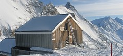


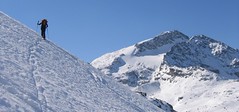
Hollandiahütte (3235 m) is a mountain hut on a rocky cliff above the Lötschenlückensattel, which forms the western edge of the huge Großer Aletschgletscher glacier. Starting point for ski tours to Ebnerfluh (Äbeni Flue) and Mittaghorn. The hut is easier to reach from the Jungfraujoch saddle either via the Konkordiaplatz or the Louwitor saddle. A long ascent from Lötschental brings good acclimatization.
Tours starting from hut
Ski tours around Hut Hollandiahütte (Lötschenhütte)

- Country
- Switzerland
- Montains
- Berner Alpen / Alpes bernoises
- Open (winter)
- mid March - mid May
- Beds
- 85
- Winterraum
- 12
- Shortening of access (cableway, lift, taxi, snowcat...)
- yes, by train to Jungfraujoch
- Luggage transport
- no
- Card Pay
- yes
- Shower
- yes
- Wifi
- no
- UTM / CH1903 x ("longitude" E/W)
- 640060
- UTM / CH1903 y ("latitude" N/S)
- 147240
- Map
- Jungfrau 264 S, 1:50000 Finsteraarhorn, Landeskarte Schweiz Nr. 1249, 1:25000 Lötschental, Landeskarte Schweiz Nr. 1268, 1:25000
- Guides
- Berner Alpen Ost / SAC, deutsch Die klassischen Skitouren / SAC, deutsch Les classiques de randonnée à ski / SAC, francais Scialpinismo in Svizzera / SAC, italiano
- Phone (hut)
- +41 27 939 11 35
- Phone (valley)
- -
- Cell phone
- +41 79 213 98 05
- Mobile Signal
- yes
- Web
- hollandiahuette.ch
- info@hollandiahuette.ch
- Owner of hut
- SAC Bern
- Hollandiahütte
- Reservation
- online form
- Online reservation
- hollandiahuette.ch
- Start Point
- Blatten - Lötschental
- UTM / CH1903 x ("longitude" E/W)
- 629413
- UTM / CH1903 y ("latitude" N/S)
- 141113
- Altitude
- 1535 m
- Ascent (height difference)
- 1720 m
- Time of Access
- 7-9 h
- Shortening lift
- no
- Start Point
- Jungfraujoch
- UTM / CH1903 x ("longitude" E/W)
- 651107
- UTM / CH1903 y ("latitude" N/S)
- 140407
- Altitude
- 3454 m
- Ascent (height difference)
- ascent 510 m, descent 740 m m
- Time of Access
- 3,5-4,5 h
- Shortening lift
- yes, accessible by train only, from Grindelwald/Lauterbrunnen
- Avalanche danger
- slf.ch - Institut für Schnee- und Lawinenforschung
- Weather
- Konkordiahuette - Meteograms Hollandiahuette / meteoblue.com Ebnerfluh 3962m / mountain-forecast.com Schinhorn 3796m / mountain-forecast.com Sattelhorn 3723m / mountain-forecast.com Alpenvereinswetter Switzerland / meteo.ch Switzerland - animation / srf.ch
- Snow report
- Konkordiahuette - Meteograms Fiesch - Eggishorn - Aletsch / snow-forecast.com Aletsch Arena / onthesnow.com Wengen/ snow-forecast.com Jungfrauregion / snow.myswitzerland.com
- Webcams
- Konkordiahuette Jungfraujoch Faffleralp
- Region
- Jungfrauregion Blatten-Lötschental
- Public traffic
- SBB Railway Bus - Postauto.ch
- Skiresort nearby
- Jungfrau Aletscharena
- Other links
- Schweiz Tourism
hut Hollandiahütte (Lötschenhütte) - Reviews
There are no reviews in this section yet. Click the Add Review button to add first review.
Best ski tours in mountains Berner Alpen / Alpes bernoises, Switzerland
-

Jungfrau 4158 m
Konkordiahütte Berner Alpen / Alpes bernoises Switzerland
- Length of ascent10 km
- ascent1510 m
- duration6,5-9 h
- Fitness difficulty ♦♦♦◊
- Technical difficulty ♦♦♦◊
Skialpová túra na Jungfrau z chaty Konkordia začíná velmi dlouhým nástupem po ledovci Jungfraufirn. Následuje prudký výstup na hřeben a dále do sedla Rottalsattel přes nepříjemnou thlinu. Skidepot a na mčkách a s cepínem po plochém hřebenu na vrchol. Alternativní sjezd přes sedlo Louwitor na ledovec Aletschfirn a po něm na chatu Konkordia. Možné je po dosažení vrcholu pokračovat na nádraží Jungfraujoch nebo nocovat na Mönchsjochhütte.

-
Mönch 4107 m
Mönchsjochhütte Berner Alpen / Alpes bernoises Switzerland
- Length of ascent2 km
- ascent525 m
- duration2,5-4 h
- Fitness difficulty ♦♦◊◊
- Technical difficulty ♦♦♦♦
Túra na impozantní Mnich (Mönch) je v podstatě dlouhou hřebenovkou v mačkách a s cepínem. S rostoucí výškou roste obtížnost. S úbytkem ledovcového příkrovu roste expozice. Pokud nejste horský vůdce, nepoužívejte techniku krátkého lana. V závěrečném úseku je každá chyba nevratná. Výstup přináší fantastický zážitek se spoustou výhledů na nádherný svět ledovců.
-

Hubelhorn (day 4, h.r. Swiss Glacier) 3244 m
Bächlitalhütte Berner Alpen / Alpes bernoises Switzerland
- Length of ascent11,5 km
- ascent1730 m
- duration9-11 h
- Fitness difficulty ♦♦♦◊
- Technical difficulty ♦♦♦◊
The Hubelhorn skitour is an ideal extension of the crossing between the Bächlitalhütte and Gaulihütte. After a short ride from the saddle, Obri Bächlilicke climbs through the steep east slope into the rocky saddle and then slightly up the crossing to Hubelhorn. Beware of some hot spots at the Gauligletscher Glacier. From Gauli hut is a nice tour through the northern slope, but in the opposite direction.
Best ski tours in Switzerland by skitour.guru
-

Tour du Ciel - day 3 3649 m
Cabane du Mountet Walliser Alpen / Alpes valaisannes Switzerland
- Length of ascent10,5 km
- ascent2420 m
- duration10-12 h
- Fitness difficulty ♦♦♦♦
- Technical difficulty ♦♦♦♦
A very long and demanding, royal stage of this Haute Route. In my opinion, the most impressive stage of all multi-day Alpine crossings. Due to the elevation gain and time required, it’s worth considering splitting the stage into two days with an overnight stay in Zinal. The long, exposed ridge to the summit requires rope protection depending on conditions. The descent is fantastically long, but caution is needed – there are large crevasses. This ski tour is only recommended in stable weather; in poor conditions, it’s advisable to bypass the Blanc de Moming via the Glacier de Zinal and ascend directly to the Cabane de Tracuit.
-
Piz Surlej - Piz San Gian 3187 m
St. Moritz Bernina Alps Switzerland
- Length of ascent4 km
- ascent990 m
- duration4-6 h
- Fitness difficulty ♦♦◊◊
- Technical difficulty ♦♦♦◊
Piz Surlej and Piz San Gian is an interesting ski tour over two neighboring peaks. In the morning you take the cable car to Piz Corvatsch and enjoy the wonderful view of the Albula Alps as well as the lakes Sils and Silvaplana. Follow the ski slope to the Margun Vegl cable car station or to the upper station (2643 m). A logical line to Piz Surlej and further along the ridge to Piz San Gian. And then a spectacular descent to St. Moritz. Warning, some slopes of this ski tour have avalanche potential, especially the descent from the San Gian summit to St. Moritz. This tour is for skiers with good riding technique.
-

La Luette 3547 m
Cabane des Dix Walliser Alpen / Alpes valaisannes Switzerland
- Length of ascent3 km
- ascent710 m
- duration1,5-3 h
- Fitness difficulty ♦♦◊◊
- Technical difficulty ♦♦◊◊
La Luette je vděčná túra z chaty Cabane Dix. Po mírném svahu na ledovec Glacier de la Luette a v závěru po hřebenu na vrchol. Pouhých 500 výškových metrů od chaty může být lákadlem pro odpolední túru poté, když dorazíte brzo na chatu Dix.