
 Česky
Česky Deutsch


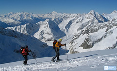
The Mönchsjochhütte lies at an altitude of 3650 m and is therefore the highest hut in Switzerland (managed). The Mönchsjochhütte is not far from the highest train station in Europe. The hut is an ideal starting point for ski tours to Mönch and Jungfrau.
Tours starting from hut
Ski tours around Hut Mönchsjochhütte
-
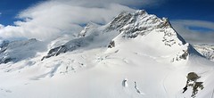
Jungfrau 4158 m
Mönchsjochhütte Berner Alpen / Alpes bernoises Switzerland
- Length of ascent6 km
- ascent1430 m
- duration4,5-7 h
- Fitness difficulty ♦♦♦◊
- Technical difficulty ♦♦♦◊
Jungfrau is a very popular 4000 in the Bernese Alps. From the highest train station in Europe - the Jungfraujoch - you can easily board. But be careful, don't climb to the top without acclimatizing! Not far from the Jungfraujoch station is the Mönchsjochhütte or above the confluence of the Aletschgletscher Konkordia Hut. The only complication of the ascent is glacier cracks. Overcoming the crevasse under the Rottasattel can be complicated. The last climb up to the summit is climbed without skis. The descent line follows the ascent track. You have to reckon with a 450 hm ascent return to the hut.

-
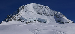
Mönch 4107 m
Mönchsjochhütte Berner Alpen / Alpes bernoises Switzerland
- Length of ascent2 km
- ascent525 m
- duration2,5-4 h
- Fitness difficulty ♦♦◊◊
- Technical difficulty ♦♦♦♦
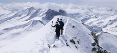
Túra na impozantní Mnich (Mönch) je v podstatě dlouhou hřebenovkou v mačkách a s cepínem. S rostoucí výškou roste obtížnost. S úbytkem ledovcového příkrovu roste expozice. Pokud nejste horský vůdce, nepoužívejte techniku krátkého lana. V závěrečném úseku je každá chyba nevratná. Výstup přináší fantastický zážitek se spoustou výhledů na nádherný svět ledovců.
-
Grosses Grünhorn 4044 m
Mönchsjochhütte Berner Alpen / Alpes bernoises Switzerland
- Length of ascent3,5 km
- ascent970 m
- duration6-8 h
- Fitness difficulty ♦♦♦◊
- Technical difficulty ♦♦♦◊
Grosses Grünhorn je jediná 4000vka v oblasti chaty Konkordiahütte. Výstup z chaty Mönchsjochhütte vede z po ledovci Ewigschneefeld a následně po severozápadních svazích na hřeben Grünhornu. Pozor na ledovcové trhliny. Nedaleko od sedla je skidepot od kterého se jde na vrchol v mačkách. Sjezd pokračuje logicky na Konkordiaplatz a túra končí na chatě Konkordia. Tak je to ideální. Alternativou je výstup sjezd přes vrchol Grünegghorn, na který se musí vylézt s lyžemi na batohu.
- Country
- Switzerland
- Montains
- Berner Alpen / Alpes bernoises
- Open (winter)
- March - mid May
- Beds
- 120
- Winterraum
- 16
- Shortening of access (cableway, lift, taxi, snowcat...)
- yes, by train to Jungfraujoch or cable car Fiesch - Fiescheralp
- Luggage transport
- yes, by snowcat from Jungfraujoch
- Card Pay
- yes
- Shower
- no
- Wifi
- no
- UTM / CH1903 x ("longitude" E/W)
- 643500
- UTM / CH1903 y ("latitude" N/S)
- 156100
- GPX access to hut (waipoints, track)
- MoenchsjochHut_access_all_skitour.gpx
- GPX access to hut (track only)
- MoenchsjochHut_access_all_TRK.gpx
- GPX all tours from the hut
- MoenchsjochHut_ALL_skitour.gpx
- Map
- Jungfrau 264 S, 1:50000 Finsteraarhorn, Landeskarte Schweiz Nr. 1249, 1:25000
- Guides
- Berner Alpen Ost / SAC, deutsch Die klassischen Skitouren / SAC, deutsch Les classiques de randonnée à ski / SAC, francais Scialpinismo in Svizzera / SAC, italiano
- Phone (hut)
- +41 33 971 34 72
- Phone (valley)
- +41 79 933 08 67
- Cell phone
- -
- Mobile Signal
- yes
- Web
- moenchsjoch.ch
- info@moenchsjoch.ch
- Owner of hut
- Genossenschaft Mönchsjochhütte
- Mönchsjochhütte
- Reservation
- online
- Online reservation
- alpsonline.org
- Start Point
- Finsteraarhornhütte
- UTM / CH1903 x ("longitude" E/W)
- 651 860
- UTM / CH1903 y ("latitude" N/S)
- 152 520
- Altitude
- 3048 m
- Ascent (height difference)
- ascent 1495 hm, descent 885 hm m
- Time of Access
- 5-6,5 h
- Shortening lift
- no
- Start Point
- Konkordiahütte
- UTM / CH1903 x ("longitude" E/W)
- 647009
- UTM / CH1903 y ("latitude" N/S)
- 150087
- Altitude
- 2850 m
- Ascent (height difference)
- ascent 1100 hm, descent 175 hm, 10 k m
- Time of Access
- 3-4 h
- Shortening lift
- no
- Avalanche danger
- slf.ch - Institut für Schnee- und Lawinenforschung
- Weather
- Konkordiahuette - Meteograms Jungfraujoch / meteoblue.com Trugberg 3880m / mountain-forecast.com Gross Fiescherhorn 4049m / mountain-forecast.com Alpenvereinswetter Switzerland / meteo.ch Switzerland - animation / srf.ch
- Snow report
- Konkordiahuette - Meteograms Aletsch Arena / onthesnow.com Wengen/ snow-forecast.com Jungfrauregion / snow.myswitzerland.com
- Webcams
- Konkordiahuette Jungfraujoch Eggishorn
- Region
- Jungfrauregion
- Public traffic
- SBB Railway Bus - Postauto.ch
- Skiresort nearby
- Jungfrau Aletscharena
- Other links
- Schweiz Tourism
hut Mönchsjochhütte - Reviews
There are no reviews in this section yet. Click the Add Review button to add first review.
Best ski tours in mountains Berner Alpen / Alpes bernoises, Switzerland
-
Grosses Grünhorn 4044 m
Konkordiahütte Berner Alpen / Alpes bernoises Switzerland
- Length of ascent7 km
- ascent1380 m
- duration6,5-8,5 h
- Fitness difficulty ♦♦♦◊
- Technical difficulty ♦♦♦◊
Gross Grünhorn is the only 4000 meter in the Konkordiahütte area. The ascent leads from Konkordiaplatz along the edge of the Ewigschneefeld glacier and then along the northwestern slopes of the Grünhorn ridge. Beware of glacier cracks around the saddle between Grünegghorn and Gross Grünhorn. Not far from the saddle is a ski depot, from which you can go up with crampons and ice ax. The descent along the ascent route is safer than the descent variant through Grüneggfirn (glacier cracks).
-

Jungfrau 4158 m
Konkordiahütte Berner Alpen / Alpes bernoises Switzerland
- Length of ascent10 km
- ascent1510 m
- duration6,5-9 h
- Fitness difficulty ♦♦♦◊
- Technical difficulty ♦♦♦◊
Skialpová túra na Jungfrau z chaty Konkordia začíná velmi dlouhým nástupem po ledovci Jungfraufirn. Následuje prudký výstup na hřeben a dále do sedla Rottalsattel přes nepříjemnou thlinu. Skidepot a na mčkách a s cepínem po plochém hřebenu na vrchol. Alternativní sjezd přes sedlo Louwitor na ledovec Aletschfirn a po něm na chatu Konkordia. Možné je po dosažení vrcholu pokračovat na nádraží Jungfraujoch nebo nocovat na Mönchsjochhütte.
-
Grosser Aletschhorn 4189 m
Oberaletschhütte Berner Alpen / Alpes bernoises Switzerland
- Length of ascent7 km
- ascent1750 m
- duration7-9 h
- Fitness difficulty ♦♦♦♦
- Technical difficulty ♦♦♦◊
Grosser Aletschhorn is lonely 4000 in the middle of the Berner Alps in Switzerland over the Oberaletschgletscher and the hut of the same name. From the top views of the Wallis Alps, including the Matterhorn.
Best ski tours in Switzerland by skitour.guru
-

Pigne d´Arolla 3790 m
Cabane des Dix Walliser Alpen / Alpes valaisannes Switzerland
- Length of ascent6 km
- ascent1000 m
- duration5-7,5 h
- Fitness difficulty ♦♦◊◊
- Technical difficulty ♦♦♦◊
Pigne d´Arolla is a very popular and easily accessible viewpoint. The ski tour to the summit leads from the three mountain huts - Cabane Dix, Cabane Vignettes and Cabane Chanrion. The route from Dix goes around the glacial seracs to the saddle Col de la Serpentine and the summit can be reached on skis. A worthwhile summit on the Haute Routes to Zermatt.
-

Isenfürggli 2765 m
Davos Albula Alps Switzerland
- Length of ascent3 km
- ascent845 m
- duration2,5-3,5 h
- Fitness difficulty ♦♦◊◊
- Technical difficulty ♦♦◊◊
The ascent to the Isenfürggli saddle is a worthwhile addition after successful descents from Pischahorn or Isentällispitz. Especially in firn conditions or fresh powder, it is a rewarding destination. From the saddle, there is a beautiful view of the Silvretta range, with the striking Piz Linard as its centerpiece.
-

Chli Bielenhorn 2940 m
Andermatt - Realp - Oberalppass Urner Alps Switzerland
- Length of ascent8,5 km
- ascent1450 m
- duration5-6,5 h
- Fitness difficulty ♦♦♦◊
- Technical difficulty ♦♦◊◊
Chli Bielenhorn je skalnatá špička v říši monumentálních žulových stěn divokých hor. Začátek kolem silnice na Furkapass pokračuje po pláni pod chatou Albert-Heim-Hütte. Pak přichází v sousedství pohled na ledovce monumentálního Dammastocku. V kulisách skal vede logická linie ke skidepu kousek pod vrcholem. V případě stabilního sněhu je fajn alternativou sjezdová linie jižně od výstupové stopy a dále členitým terénem k hotelu Tiefenbach a v okolí silnice nebo po ní zpět do Realpu.