
 Česky
Česky Deutsch


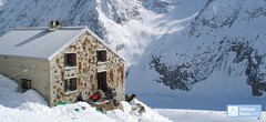
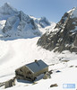


Oberaletschhütte is the classical SAC (Swiss Alpinist Club) mountain hut above the glacier Oberaletschgletscher in the Bernese Alps. The beginnings of demanding glacier skitours - Grosser and Klein Aletschhorn, Beichpass, Belalp, Breithorn, Gredetschjoch, Nesthorn, Sattelhorn, Schinhorn.
Tours starting from hut
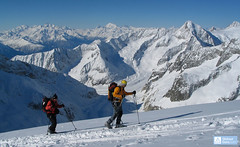
Ski tours around Hut Oberaletschhütte
-
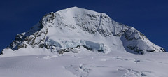
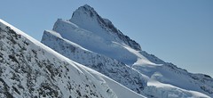
Grosser Aletschhorn 4189 m
Oberaletschhütte Berner Alpen / Alpes bernoises Switzerland
- Length of ascent7 km
- ascent1750 m
- duration7-9 h
- Fitness difficulty ♦♦♦♦
- Technical difficulty ♦♦♦◊
Grosser Aletschhorn is lonely 4000 in the middle of the Berner Alps in Switzerland over the Oberaletschgletscher and the hut of the same name. From the top views of the Wallis Alps, including the Matterhorn.

-

Sattelhorn 3745 m
Oberaletschhütte Berner Alpen / Alpes bernoises Switzerland
- Length of ascent7 km
- ascent1300 m
- duration7-9 h
- Fitness difficulty ♦♦♦◊
- Technical difficulty ♦♦♦◊
Sattelhorn (Berner Alpen, Oberaletschhütte) is a challenging glacier tour with a very steep section (35-40°).
- Country
- Switzerland
- Montains
- Berner Alpen / Alpes bernoises
- Open (winter)
- April-May
- Beds
- 58
- Winterraum
- 0
- Shortening of access (cableway, lift, taxi, snowcat...)
- no
- UTM / CH1903 x ("longitude" E/W)
- 641146
- UTM / CH1903 y ("latitude" N/S)
- 141647
- GPX access to hut (waipoints, track)
- Oberaletschhuette ACCESS SkitourGuru.gpx
- GPX all tours from the hut
- Oberaletschhuette CH_BernerAlpen_SkitouGuru.gpx
- Map
- Jungfrau 264 S, 1:25000 Aletschgletscher 1269, 1:25000
- Guides
- Hütten der Schweizer Alpen Skitouren Berner Alpen Ost
- Phone (hut)
- 079 434 31 41
- Phone (valley)
- -
- Cell phone
- -
- Web
- www.oberaletsch.ch
- info@oberaletsch.ch
- Owner of hut
- CAS Chasseral
- Start Point
- Belalp - cableway upper station
- UTM / CH1903 x ("longitude" E/W)
- 641473
- UTM / CH1903 y ("latitude" N/S)
- 136299
- Altitude
- 2094 m
- Ascent (height difference)
- 800 m
- Time of Access
- 4-6 h
- Shortening lift
- yes, cableway Blatten - Belalp
- Avalanche danger
- SLF
- Weather
- meteo.ch meteoschweiz.ch SRF meteoblue.com - Belalp yr.no - Belalp yr.no - Aletschhorn
- Snow report
- bergfex.ch snow-forecast.com schneeradar.de onthesnow.com
- Webcams
- swisswebcams.ch - Belalp Aletschbord swisswebcams.ch - Belalp swisswebcams.ch - Riederalp (Aletsch Arena) swisswebcams.ch - Bettmeralp (Aletsch Arena) swisswebcams.ch - Konkordiahütten
- Region
- Belalp Blatten Wallis
- Public traffic
- Postbus Switzerland Railways
- Skiresort nearby
- Belalp Aletscharena
hut Oberaletschhütte - Reviews
There are no reviews in this section yet. Click the Add Review button to add first review.
Best ski tours in mountains Berner Alpen / Alpes bernoises, Switzerland
-

Äbeni Flue - Ebnerfluh 3962 m
Hollandiahütte (Lötschenhütte) Berner Alpen / Alpes bernoises Switzerland
- Length of ascent4,5 km
- ascent800 m
- duration3,5-5 h
- Fitness difficulty ♦♦◊◊
- Technical difficulty ♦♦◊◊
Relatively easy glacier ski tour to the most popular summit of the Hollandia hut. The glacier is not too cracked and the ascent path is gradually gaining altitude. At the end, ridge is waiting between the secondary and main summits. With good visibility it is a ski tour without complications.
-
Mönch 4107 m
Mönchsjochhütte Berner Alpen / Alpes bernoises Switzerland
- Length of ascent2 km
- ascent525 m
- duration2,5-4 h
- Fitness difficulty ♦♦◊◊
- Technical difficulty ♦♦♦♦
Túra na impozantní Mnich (Mönch) je v podstatě dlouhou hřebenovkou v mačkách a s cepínem. S rostoucí výškou roste obtížnost. S úbytkem ledovcového příkrovu roste expozice. Pokud nejste horský vůdce, nepoužívejte techniku krátkého lana. V závěrečném úseku je každá chyba nevratná. Výstup přináší fantastický zážitek se spoustou výhledů na nádherný svět ledovců.
-
Finsteraarhorn 4374 m
Finsteraarhornhütte Berner Alpen / Alpes bernoises Switzerland
- Length of ascent3,5 km
- ascent1280 m
- duration7-9,5 h
- Fitness difficulty ♦♦♦◊
- Technical difficulty ♦♦♦♦
Na vrchol Finsteraarhorn míří náročná ledovcová túra z chaty Finsteraarhornhütte. Hned od začátku túry jsou cestou velkolepé výhledy. Náročnější je překonání skalního žebra. Po ledovci do sedla Hugisattel s leteckým pohledem na východní stěnu. Zde je skidepot a dál v mačkách a s cepínem na skialpové poměry náročným terénem. Obtížnost lezení zásadně ovlivňuje množství a konzistence sněhu na skále. Náročný sjezd prudkými svahy kopíruje linii výstupu.
Best ski tours in Switzerland by skitour.guru
-

Piz Bernina 4048 m
Chamanna Boval / Bovalhütte Bernina Alps Switzerland
- Length of ascent7,5 km
- ascent1695 m
- duration8-10,5 h
- Fitness difficulty ♦♦♦♦
- Technical difficulty ♦♦♦♦
Piz Bernina is the only 4000m peak in the Eastern Alps. The greatest danger are the huge and numerous crevasses on the Morteratsch Glacier and the ridge to the summit. Piz Bernina sets off from Chamanna Boval or Rifugio Marco e Rosa on the plateau below the summit. Bernina is a demanding alpine challenge.
-

Vordere/ Hintere Jamspitze SW 3155 m
Tuoi Chamonna / Tuoihütte Silvretta Switzerland
- Length of ascent km
- ascent910 m
- duration3-4 h
- Fitness difficulty ♦♦◊◊
- Technical difficulty ♦♦◊◊
-

Blanc de Moming - Dôme Circuit 3649 m
Cabane du Mountet Walliser Alpen / Alpes valaisannes Switzerland
- Length of ascent10 km
- ascent2035 m
- duration9-11 h
- Fitness difficulty ♦♦♦♦
- Technical difficulty ♦♦♦♦
Blanc de Moming - Dôme is a beautiful but also very demanding complex ski tour. First ascent from Cabane Mountet to La Forcle saddle and then not very easy descent and then ascent along the Glacier du Besso. At the end of the glacier there is an uncomfortable border between snow and rock. Climb a rocky slope. First along a flat ridge, which is increasingly exposed. It is recommended to belay in windy weather. At the beginning of the spectacular descent along the Glacier de Moming, pay attention to the gigantic cracks. The departure line (keep left) turns from the northern to the western slope. After reaching the valley there is an easy ascent along the Glacier de Zinal back to Cabane Mountet.