
 Česky
Česky Deutsch


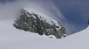
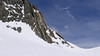
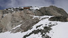
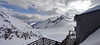
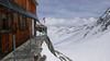
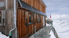
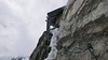

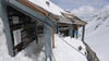


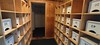


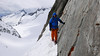
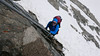

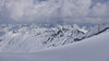
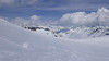
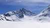
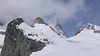

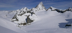
The Oberaarjochhütte is a modernized mountain hut with a unique location above the Oberaarjoch Pass. It is built on a rock ledge and is therefore accessible only by ladder. Its advantage lies in its seclusion from the main flow of ski tourers. On the crossing from the Konkordia or Finsteraarhornhütte, you can enjoy the romance of the high mountains without any people around. From the hut, you can see the imposing face of Finsteraarhorn. The hut serves as the starting point for Vordere Galmihorn, and with the subsequent descent into the Goms Valley, you elegantly complete the Haute Route of the Bernese Alps.
Tours starting from hut
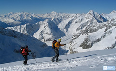
Ski tours around Hut Oberaarjochhütte
- Country
- Switzerland
- Montains
- Berner Alpen / Alpes bernoises
- Open (winter)
- April - beginning May
- Beds
- 40
- Winterraum
- 22
- Shortening of access (cableway, lift, taxi, snowcat...)
- no
- Luggage transport
- no
- Card Pay
- no
- Shower
- no
- Wifi
- no
- UTM / CH1903 x ("longitude" E/W)
- 656349
- UTM / CH1903 y ("latitude" N/S)
- 153007
- GPX access to hut (waipoints, track)
- OberaarjochHut_ALL_skitours.gpx
- GPX access to hut (track only)
- OberaarjochHut_access_all_TRK.gpx
- GPX all tours from the hut
- OberaarjochHut_ALL_skitours.gpx
- Map
- Nufenenpass 265 S, Swisstopo 1:50000 Jungfrau 264 S, Swisstopo 1:50000 Ulrichen LK 1250, Swisstopo 1:25000 Jungfrau region LK 2520, Swisstopo 1:25000
- Guides
- Berner Alpen Ost, SAC Verlag Die klassischen Skitouren
- Phone (hut)
- +41 33 973 13 82
- Phone (valley)
- -
- Cell phone
- +41 (0)76 264 28 57
- Mobile Signal
- yes
- Web
- oberaarjochhuette.ch
- info@oberaarjochhuette.ch
- Owner of hut
- SAC Biel
- Reservation
- online
- Online reservation
- alpsonline.org
- Start Point
- Finsteraarhornhütte
- UTM / CH1903 x ("longitude" E/W)
- 651 860
- UTM / CH1903 y ("latitude" N/S)
- 152 520
- Altitude
- 3048 m
- Ascent (height difference)
- ascent 625 hm, descent 420 hm m
- Time of Access
- 2,5-3,5 h
- Shortening lift
- no
- Start Point
- Münster VS
- UTM / CH1903 x ("longitude" E/W)
- 663575
- UTM / CH1903 y ("latitude" N/S)
- 148561
- Altitude
- 1365 m
- Ascent (height difference)
- ascent 2650 hm, descent 760 hm m
- Time of Access
- 8-10 h
- Shortening lift
- no
- Avalanche danger
- SLF
- Weather
- Oberaarjoch, meteoblue.com Galmihorn, mountain-forecast.com Galmihorn, meteoblue.com Oberaarhorn, mountain-forecast.com Finsteraarhorn / meteoblue.com Alpenverein Wetter Switzerland / meteo.ch Switzerland - animation / srf.ch
- Snow report
- Konkordiahuette - Meteograms Goms - Obergoms / snow-forecast.com Goms / snow.myswitzerland.com Aletsch Arena / onthesnow.com Jungfrauregion / snow.myswitzerland.com
- Webcams
- Oberaarsee, Konkordiahütte
- Region
- Grimselwelt.ch Goms.ch Jungfaru Region
- Public traffic
- Train - sbb.ch Bus - postauto.ch
- Skiresort nearby
- Obergoms / Goms Jungfrau - Grindelwald - Wengen
- Other links
- Schweiz Tourismus Moje Švýcarsko
hut Oberaarjochhütte - Reviews
There are no reviews in this section yet. Click the Add Review button to add first review.
Best ski tours in mountains Berner Alpen / Alpes bernoises, Switzerland
-

Hubelhorn (day 4, h.r. Swiss Glacier) 3244 m
Bächlitalhütte Berner Alpen / Alpes bernoises Switzerland
- Length of ascent11,5 km
- ascent1730 m
- duration9-11 h
- Fitness difficulty ♦♦♦◊
- Technical difficulty ♦♦♦◊
The Hubelhorn skitour is an ideal extension of the crossing between the Bächlitalhütte and Gaulihütte. After a short ride from the saddle, Obri Bächlilicke climbs through the steep east slope into the rocky saddle and then slightly up the crossing to Hubelhorn. Beware of some hot spots at the Gauligletscher Glacier. From Gauli hut is a nice tour through the northern slope, but in the opposite direction.

-
Grosser Aletschhorn 4189 m
Oberaletschhütte Berner Alpen / Alpes bernoises Switzerland
- Length of ascent7 km
- ascent1750 m
- duration7-9 h
- Fitness difficulty ♦♦♦♦
- Technical difficulty ♦♦♦◊
Grosser Aletschhorn is lonely 4000 in the middle of the Berner Alps in Switzerland over the Oberaletschgletscher and the hut of the same name. From the top views of the Wallis Alps, including the Matterhorn.
-

Jungfrau 4158 m
Konkordiahütte Berner Alpen / Alpes bernoises Switzerland
- Length of ascent10 km
- ascent1510 m
- duration6,5-9 h
- Fitness difficulty ♦♦♦◊
- Technical difficulty ♦♦♦◊
Skialpová túra na Jungfrau z chaty Konkordia začíná velmi dlouhým nástupem po ledovci Jungfraufirn. Následuje prudký výstup na hřeben a dále do sedla Rottalsattel přes nepříjemnou thlinu. Skidepot a na mčkách a s cepínem po plochém hřebenu na vrchol. Alternativní sjezd přes sedlo Louwitor na ledovec Aletschfirn a po něm na chatu Konkordia. Možné je po dosažení vrcholu pokračovat na nádraží Jungfraujoch nebo nocovat na Mönchsjochhütte.
Best ski tours in Switzerland by skitour.guru
-

Piz Bernina 4048 m
Chamanna Boval / Bovalhütte Bernina Alps Switzerland
- Length of ascent7,5 km
- ascent1695 m
- duration8-10,5 h
- Fitness difficulty ♦♦♦♦
- Technical difficulty ♦♦♦♦
Piz Bernina is the only 4000m peak in the Eastern Alps. The greatest danger are the huge and numerous crevasses on the Morteratsch Glacier and the ridge to the summit. Piz Bernina sets off from Chamanna Boval or Rifugio Marco e Rosa on the plateau below the summit. Bernina is a demanding alpine challenge.
-
Piz Muragl 3156 m
Muottas Muragl - Romantik Hotel Albula Alps Switzerland
- Length of ascent6 km
- ascent780 m
- duration4,5,5 h
- Fitness difficulty ♦♦◊◊
- Technical difficulty ♦♦◊◊
Piz Muragl je dokonalá vyhlídková hora. Výstup ulehčí zubačka na Muottas Muragl a příjemný sjezd dovede lyžaře na parkoviště u vláčku. Perfektní výhledy na velikány masivu Bernina i kaskádu jezer kolem St. Moritz. Technicky nenáročná túra.
-

Isenfürggli 2765 m
Davos Albula Alps Switzerland
- Length of ascent3 km
- ascent845 m
- duration2,5-3,5 h
- Fitness difficulty ♦♦◊◊
- Technical difficulty ♦♦◊◊
The ascent to the Isenfürggli saddle is a worthwhile addition after successful descents from Pischahorn or Isentällispitz. Especially in firn conditions or fresh powder, it is a rewarding destination. From the saddle, there is a beautiful view of the Silvretta range, with the striking Piz Linard as its centerpiece.