
 Česky
Česky Deutsch


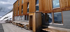

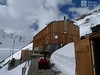
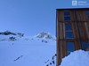

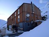

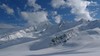
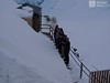


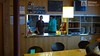
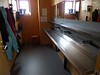

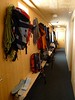

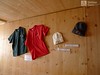
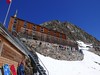


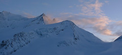
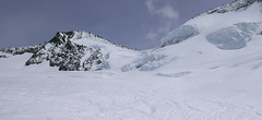
The Finsteraarhornhütte is a modern, large mountain hut at the foot of the highest mountain in the Bernese Alps - Finsteraarhorn (4374 m). Starting point for ski tours to other peaks - Ht.Fiescherhorn, Gr. Fiescherhorn and Gr. Wannenhorn. The new house was built in 2003 from steel and wood. Very cozy hut, completely free of mobile signals and internet.
Tours starting from hut
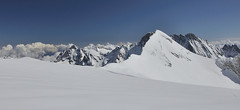
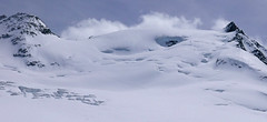
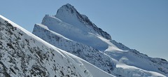
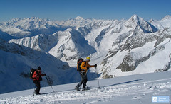
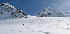
Ski tours around Hut Finsteraarhornhütte
-
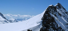
Wyssnollen 3589 m
Finsteraarhornhütte Berner Alpen / Alpes bernoises Switzerland
- Length of ascent4,5 km
- ascent865 m
- duration3-4,5 h
- Fitness difficulty ♦♦◊◊
- Technical difficulty ♦♦◊◊
Skialpová túra na Wyssnollen je alternativní túrou pro případ nižší oblačnosti a obecně horích podmínek v oblasti chaty Finteraarhornhütte. Situaci na kopci můžete snadno vyhodnotit z okna chaty - je přímo naproti přes ledovec Fieschergletcher. Pozor, je to stále hora pokrytá ledovcem, tedy pozor na trhliny.

-
Grosses Fiescherhorn 4049 m
Finsteraarhornhütte Berner Alpen / Alpes bernoises Switzerland
- Length of ascent7 km
- ascent1260 m
- duration5,5-7,5 h
- Fitness difficulty ♦♦♦◊
- Technical difficulty ♦♦♦◊
Dlouhá ledovcová túra na Grosses Fiescherhorn se dá podniknout z chaty Finsteraarhornhütte (ledovec Walliser Fiescherfirn) nebo opačným směrem z Mönchsjochhütte (ledovec Ewigschneefäld). Poměrně dlouhá túra vybízí ke zdolání i sousední Hinteres Fiescherhorn, který má cestu na vrchol ze sedla Fieschersattel o něco lehčí. Toto sedlo je vhodné pro přesun na chatu Finsteraarhornhütte z vláčku na Jungfraujoch i opačným směrem.
-
Vorderes Galmihorn 3507 m
Finsteraarhornhütte Berner Alpen / Alpes bernoises Switzerland
- Length of ascent4,5 km
- ascent890 m
- duration4,5-6 h
- Fitness difficulty ♦♦♦◊
- Technical difficulty ♦♦♦◊
Vorderes Galmihorn je skvělý skialpový vrchol na závěr akce v centru Bernských Alp. Po výstupu na vrchol z chaty Finsteraarhornhütte nebo Oberaletschhütte nabízí skvělou možnost sjezdu do údolí Goms, což je logistická výhra v případě startu lanovkou z Fiesch. Výstup vede po mírném ledovci Fiechergletscher a svah po trhlinami posetém, ale přehledném ledovci Galmigletscher. Při sjezdu dávejte pozor na trhlinu pod sedlem Bächlilicke. Na jaře vás v závěru túry nemine pochod do údolí s lyžemi na batohu. Nabízí se sjezd do Reckingenu nebo Münsteru.
-

Gross Wannenhorn 3905 m
Finsteraarhornhütte Berner Alpen / Alpes bernoises Switzerland
- Length of ascent6,5 km
- ascent1310 m
- duration5,5-7,5 h
- Fitness difficulty ♦♦♦◊
- Technical difficulty ♦♦♦◊
The top of the Gross Wannenhorn is a first-class lookout tower on the largest alpine glacier, the Aletsch glacier and the many 4,000-meter peaks in the Bernese Alps. After a short descent from the Finsteraarhorn Hut over the glacier Fieschergletscher at the foot of the Wannenhorn. During the ascent along a wide slope, watch out for numerous and large crevasses. Finally, the ascent line turns westwards upwards. When driving downhill, copy the exit route and pay attention to crevasses again.
-
Finsteraarhorn 4374 m
Finsteraarhornhütte Berner Alpen / Alpes bernoises Switzerland
- Length of ascent3,5 km
- ascent1280 m
- duration7-9,5 h
- Fitness difficulty ♦♦♦◊
- Technical difficulty ♦♦♦♦
Na vrchol Finsteraarhorn míří náročná ledovcová túra z chaty Finsteraarhornhütte. Hned od začátku túry jsou cestou velkolepé výhledy. Náročnější je překonání skalního žebra. Po ledovci do sedla Hugisattel s leteckým pohledem na východní stěnu. Zde je skidepot a dál v mačkách a s cepínem na skialpové poměry náročným terénem. Obtížnost lezení zásadně ovlivňuje množství a konzistence sněhu na skále. Náročný sjezd prudkými svahy kopíruje linii výstupu.
-
Hinteres Fiescherhorn 4024 m
Finsteraarhornhütte Berner Alpen / Alpes bernoises Switzerland
- Length of ascent7 km
- ascent1240 m
- duration5,5-7,5 h
- Fitness difficulty ♦♦♦◊
- Technical difficulty ♦♦◊◊
Dlouhá ledovcová túra na Hinteres Fiescherhorn se dá podniknout z chaty Finsteraarhornhütte (ledovec Walliser Fiescherfirn) nebo opačným směrem z Mönchsjochhütte (ledovec Ewigschneefäld). Poměrně dlouhá túra vybízí ke zdolání i sousední Grosses Fiescherhorn, který má cestu na vrchol ze sedla Fieschersattel o něco lehčí. Toto sedlo je vhodné pro přesun na chatu Finsteraarhornhütte z vláčku na Jungfraujoch i opačným směrem.
- Country
- Switzerland
- Montains
- Berner Alpen / Alpes bernoises
- Open (winter)
- mid March - end May
- Beds
- 106
- Winterraum
- open, 10 beds
- Shortening of access (cableway, lift, taxi, snowcat...)
- yes, by train to Jungfraujoch or cable car Fiesch - Fiescheralp
- Luggage transport
- no
- Card Pay
- no
- Shower
- no
- Wifi
- no
- UTM / CH1903 x ("longitude" E/W)
- 651 860
- UTM / CH1903 y ("latitude" N/S)
- 152 520
- GPX access to hut (waipoints, track)
- FinsteraarhornHut_access_all_skitour.gpx
- GPX access to hut (track only)
- FinsteraarhornHut_access_all_TRK.gpx
- GPX all tours from the hut
- FinsteraarhornHut_ALL_skitours.gpx
- Map
- Jungfrau 264 S, 1:50000 Finsteraarhorn, Landeskarte Schweiz Nr. 1249, 1:25000 Aletschgletscher, Landeskarte Schweiz Nr. 1269, 1:25000
- Guides
- Berner Alpen Ost / SAC, deutsch Die klassischen Skitouren / SAC, deutsch Les classiques de randonnée à ski / SAC, francais Scialpinismo in Svizzera / SAC, italiano
- Phone (hut)
- +41 33 855 29 55
- Phone (valley)
- +41 33 853 57 34
- Cell phone
- -
- Mobile Signal
- no
- Web
- finsteraarhornhuette.ch
- info@finsteraarhornhuette.ch
- Owner of hut
- SAC Oberhäsli
- SAC Finsteraarhorn Hütte
- Reservation
- online form
- Online reservation
- finsteraarhornhuette.ch
- Start Point
- Fiescheralp (Eggishorn cable way)
- UTM / CH1903 x ("longitude" E/W)
- 651107
- UTM / CH1903 y ("latitude" N/S)
- 140407
- Altitude
- 2215 m
- Ascent (height difference)
- ascent 1280 hm, descent 980 hm m
- Time of Access
- 7-8,5 h
- Shortening lift
- yes, from Fiesch to Fiescheralp
- Start Point
- Jungfraujoch
- UTM / CH1903 x ("longitude" E/W)
- 641939
- UTM / CH1903 y ("latitude" N/S)
- 155280
- Altitude
- 3454 m
- Ascent (height difference)
- ascent 890 hm, descent 1500 hm m
- Time of Access
- 3,5-5 h
- Shortening lift
- yes, accessible by train only, from Grindelwald/Lauterbrunnen
- Start Point
- Konkordiahütte
- UTM / CH1903 x ("longitude" E/W)
- 647009
- UTM / CH1903 y ("latitude" N/S)
- 150087
- Altitude
- 2850 m
- Ascent (height difference)
- ascent 670 hm, descent 1180 m m
- Time of Access
- 2-3 h
- Shortening lift
- no
- Start Point
- Oberaarjochhütte
- UTM / CH1903 x ("longitude" E/W)
- 657294
- UTM / CH1903 y ("latitude" N/S)
- 150859
- Altitude
- 3256 m
- Ascent (height difference)
- ascent 420 hm, descent 625 m m
- Time of Access
- 2-2,5 h
- Shortening lift
- no
- Avalanche danger
- slf.ch - Institut für Schnee- und Lawinenforschung
- Weather
- Konkordiahuette - Meteograms Finsteraarhorn / meteoblue.com Gr. Grünhorn 4043m / mountain-forecast.com Fiescher Gabelhorn 3876m / mountain-forecast.com Alpenvereinswetter Switzerland / meteo.ch Switzerland - animation / srf.ch
- Snow report
- Konkordiahuette - Meteograms Fiesch - Eggishorn - Aletsch / snow-forecast.com Aletsch Arena / onthesnow.com Wengen/ snow-forecast.com Jungfrauregion / snow.myswitzerland.com
- Webcams
- Konkordiahuette Jungfraujoch Eggishorn
- Region
- Jungfrauregion Fiesch-Eggishorn Seilbahn
- Public traffic
- SBB Railway Bus - Postauto.ch
- Skiresort nearby
- Jungfrau Grindelwald-Wengen Aletscharena
- Other links
- Schweiz Tourism
hut Finsteraarhornhütte - Reviews
There are no reviews in this section yet. Click the Add Review button to add first review.
Best ski tours in mountains Berner Alpen / Alpes bernoises, Switzerland
-
Grosser Aletschhorn 4189 m
Oberaletschhütte Berner Alpen / Alpes bernoises Switzerland
- Length of ascent7 km
- ascent1750 m
- duration7-9 h
- Fitness difficulty ♦♦♦♦
- Technical difficulty ♦♦♦◊
Grosser Aletschhorn is lonely 4000 in the middle of the Berner Alps in Switzerland over the Oberaletschgletscher and the hut of the same name. From the top views of the Wallis Alps, including the Matterhorn.
-

Jungfrau 4158 m
Konkordiahütte Berner Alpen / Alpes bernoises Switzerland
- Length of ascent10 km
- ascent1510 m
- duration6,5-9 h
- Fitness difficulty ♦♦♦◊
- Technical difficulty ♦♦♦◊
Skialpová túra na Jungfrau z chaty Konkordia začíná velmi dlouhým nástupem po ledovci Jungfraufirn. Následuje prudký výstup na hřeben a dále do sedla Rottalsattel přes nepříjemnou thlinu. Skidepot a na mčkách a s cepínem po plochém hřebenu na vrchol. Alternativní sjezd přes sedlo Louwitor na ledovec Aletschfirn a po něm na chatu Konkordia. Možné je po dosažení vrcholu pokračovat na nádraží Jungfraujoch nebo nocovat na Mönchsjochhütte.
-
Grosses Grünhorn 4044 m
Konkordiahütte Berner Alpen / Alpes bernoises Switzerland
- Length of ascent7 km
- ascent1380 m
- duration6,5-8,5 h
- Fitness difficulty ♦♦♦◊
- Technical difficulty ♦♦♦◊
Gross Grünhorn is the only 4000 meter in the Konkordiahütte area. The ascent leads from Konkordiaplatz along the edge of the Ewigschneefeld glacier and then along the northwestern slopes of the Grünhorn ridge. Beware of glacier cracks around the saddle between Grünegghorn and Gross Grünhorn. Not far from the saddle is a ski depot, from which you can go up with crampons and ice ax. The descent along the ascent route is safer than the descent variant through Grüneggfirn (glacier cracks).
Best ski tours in Switzerland by skitour.guru
-

Col Valpelline, Day 6 H.R. Chamonix-Zermatt 3551 m
Cabane des Vignettes Walliser Alpen / Alpes valaisannes Switzerland
- Length of ascent9 km
- ascent1485 m
- duration8-10 h
- Fitness difficulty ♦♦♦◊
- Technical difficulty ♦♦♦◊
The last stage of the Haute Route Chamonix - Zermatt is an ode to skiing. After an easy ascent to three saddles - Col de Eveque, Col du Mont Brulé and Col Valpelline. Every ski mountaineer will be amazed by the panorama of the impressive 4000m peaks - Dent Blanche, Matterhorn and Dent d´Hérens. This is followed by a 10 km descent to Zermatt.
-
Flüela Wisshorn 3085 m
Davos Albula Alps Switzerland
- Length of ascent6,5 km
- ascent1360 m
- duration5,5-7 h
- Fitness difficulty ♦♦◊◊
- Technical difficulty ♦♦♦◊
Flüela Wisshorn is the most interesting ski tour around Davos. It is offered to do an interesting round with two great downhills. The north slope to the Jöriseen lakes promises powder, while the south slopes to the Flüelatal valley promise firn. The ascent is not very demanding, at the end to the summit without skis with the help of crampons, then down to Jöriseen and noc once in the nameless saddle. Finally departure to the Flüelatal. Attention, in 2019 there was a landslide of stones in the area of the ascent route, which therefore changes the ascent route.
-

Chli Bielenhorn 2940 m
Andermatt - Realp - Oberalppass Urner Alps Switzerland
- Length of ascent8,5 km
- ascent1450 m
- duration5-6,5 h
- Fitness difficulty ♦♦♦◊
- Technical difficulty ♦♦◊◊
Chli Bielenhorn je skalnatá špička v říši monumentálních žulových stěn divokých hor. Začátek kolem silnice na Furkapass pokračuje po pláni pod chatou Albert-Heim-Hütte. Pak přichází v sousedství pohled na ledovce monumentálního Dammastocku. V kulisách skal vede logická linie ke skidepu kousek pod vrcholem. V případě stabilního sněhu je fajn alternativou sjezdová linie jižně od výstupové stopy a dále členitým terénem k hotelu Tiefenbach a v okolí silnice nebo po ní zpět do Realpu.