
 Česky
Česky Deutsch


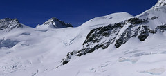


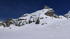


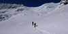


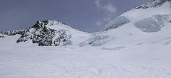
Louwihorn je hodnotná alternativa výstupu na Jungfrau z chat Mönchsjochhütte i Konkordiahütte. V Každém případě vede přes sedlo Louwitor (kousek pod vrcholem) optimální linie sjezdu po sestupu z Jungfrau - po ledovci Kranzbergfirn na Konkordiaplatz a pak po schodech na Konkordiahütte. Trasa výstupu je až do výšky 3400 m shodná s túrou na Jungfrau.
Peak
- Country
- Switzerland
- Montains
- Berner Alpen / Alpes bernoises
- Tags
- Aletschgletscher Alps 4000 Berner Alpen / Alpes bernoises Bernské Alpy Jungfraujoch Jungfrauregion Konkordiahütte Mönchsjochhütte
- Hut
- Konkordiahütte
- Other Huts
- Mönchsjochhütte
- UTM / CH1903 x ("longitude" E/W)
- 640673
- UTM / CH1903 y ("latitude" N/S)
- 153019
Start point
- Start Point
- Konkordiahütte
- Altitude
- 2850 m
- UTM / CH1903 x ("longitude" E/W)
- 647009
- UTM / CH1903 y ("latitude" N/S)
- 150087
- village, valley
- Lauterbrunnen, Grindelwald
- cableway / lift
- train to Jungfraujoch from Kleine Scheidegg
Conditions
- Avalanche danger
- slf.ch - Institut für Schnee- und Lawinenforschung
- Weather
- Konkordiahuette - Meteograms Konkordiahuette / meteoblue.com Trugberg 3880m / mountain-forecast.com Gr. Grünhorn 4043m / mountain-forecast.com Fiescher Gabelhorn 3876m / mountain-forecast.com Alpenvereinswetter Switzerland / meteo.ch Switzerland - animation / srf.ch
- Snow report
- Konkordiahuette - Meteograms Fiesch - Eggishorn - Aletsch / snow-forecast.com Aletsch Arena / onthesnow.com Wengen/ snow-forecast.com Jungfrauregion / snow.myswitzerland.com
- Webcams
- Konkordiahuette Jungfraujoch Eggishorn
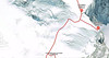
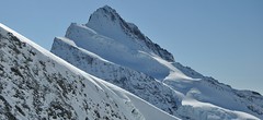
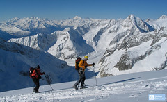
Ski tour map on Louwihorn


 bivakovací nouzová chata
  cepín a mačky potřeba
 exponovaný, obtížný terén
 horská chata
 hôtel, penzion
 lanovka, vlek
 lavinové nebezpečí, svah > 30°
 ledovcové trhliny
 lehká túra
 mimořádně obtížná túra
 mírně obtížná túra
 obtížná túra
 parkoviště
 přístup k chatě
 restaurace
 sedlo
sedlo sjezd
sjezd skidepo
 vrchol
 výstup
 začátek ledovce
- bivouac, winter room
- crampons & ice axe necessary
- exposed, difficulty terrain
- mountain hut, refuge
- hotel, pension
- cableway, skilift
- avalanche danger, slope > 30°
- glacier cracks
- little difficult tour
- extremely difficult tour
- rather difficult tour
- difficult tour
- parking
- hut acces
- restaurant
- col, pass, saddle
- descent
- skidepot
- peak, summit
- ascent
- glacier beginning
- biwak, winterraum
- steigeisen & pickel erforderlich
- ausgesetzt, schwierige gelände
- berghütte
- hotel, pension
- seilbahn, skilift
- lawinengefahr, hangneigung > 30°
- gletscherspalten
- wenig schwierige tour
- äusserst schwierige tour
- ziemlich schwierige tour
- schwierige tour
- parkplatz
- zugang zur hütte
- restaurant
- sattel, joch, pass
- abfahrt
- skidepot
- gipfel
- aufsieg
- gletscher anfang
- bivacco, locale invernale
- ramponi & piccozza necessari
- esposto, terreno difficolt?
- rifugio, capanna
- alberghi, pensione
- funivia, seggiovia
- pericolo di valanghe, pendenza > 30°
- crepe glacier
- tour piccolo difficile
- tour estremamente difficile
- tour piuttosto difficile
- escursioni difficili
- parcheggio
- accesso capanna
- ristorante
- col, sella, passo, forcella
- discesa
- sci deposito
- picco, vertice, piz
- salita
- inizio ghiacciaio
- bivouac, local d'hiver
- crampons & piolet nécessaire
- exposée, difficulté du terrain
- cabane de montagne, refuge
- hôtel, pension
- téléphérique, téléski
- danger d'avalanche, pente > 30°
- crevasse du glacier
- peu difficile tour
- extr?mement difficile tournée
- assez difficile tour
- difficile tournée
- parking
- acces cabane
- restaurant
- col, selle
- descente
- skis dépôt
- pic, sommet
- ascension
- début glacier
- < 20°
- 20° - 25°
- 25° - 30°
- 30° - 35°
- 35° - 40°
- > 40°
Current weather conditions in the tour area
Planning of ski tour
- Fitness difficulty
-
- ♦♦♦◊
- Technical difficulty
-
- ♦♦♦◊
- best time for this tour
- April-May
- Glacier
- Yes
- Map
- Jungfrau 264 S, 1:50000 Finsteraarhorn, Landeskarte Schweiz Nr. 1249, 1:25000 Aletschgletscher, Landeskarte Schweiz Nr. 1269, 1:25000
- Guides
- Berner Alpen Ost / SAC, deutsch Die klassischen Skitouren / SAC, deutsch Les classiques de randonnée à ski / SAC, francais Scialpinismo in Svizzera / SAC, italiano
About Ski tour
- Time difficulty
- Ascent (height difference)
- 1225 m
- Lenght of ascent
- 8,5 km
- Descent (height difference)
- 1225 m
- Total Lenght of tour
- 18 km
- Total time of the tour
- 5,5-7,5 h
- Elevation Range
- 2730 - 3777 m
- Principal Aspect
- SE, NE, S S-south, N-north, W-west, E-east
Download
- GPX (track only)
- Louwihorn_KonkordiaHut_TRK.gpx best for display on a detailed topographical map (mapy.cz) or in apps for smartphones (Locus, Garmin Connect, etc.)
- GPX (waipoints, track)
- Louwihorn_Konkordia_skitour.gpx great for uploading in GPS device
- KML (with POI)
- Louwihorn_KonkordiaHut_skitour.kml for viewing in the Google Earth 3D map application, which you can install on your PC
tour Louwihorn - Reviews
There are no reviews in this section yet. Click the Add Review button to add first review.
Ski tours around Hut Konkordiahütte, in mountains Berner Alpen / Alpes bernoises, Switzerland
-
Grosses Grünhorn 4044 m
Konkordiahütte Berner Alpen / Alpes bernoises Switzerland
- Length of ascent7 km
- ascent1380 m
- duration6,5-8,5 h
- Fitness difficulty ♦♦♦◊
- Technical difficulty ♦♦♦◊
Gross Grünhorn is the only 4000 meter in the Konkordiahütte area. The ascent leads from Konkordiaplatz along the edge of the Ewigschneefeld glacier and then along the northwestern slopes of the Grünhorn ridge. Beware of glacier cracks around the saddle between Grünegghorn and Gross Grünhorn. Not far from the saddle is a ski depot, from which you can go up with crampons and ice ax. The descent along the ascent route is safer than the descent variant through Grüneggfirn (glacier cracks).

-

Grünegghorn 3863 m
Konkordiahütte Berner Alpen / Alpes bernoises Switzerland
- Length of ascent4,5 km
- ascent1145 m
- duration6,5-8,5 h
- Fitness difficulty ♦♦♦◊
- Technical difficulty ♦♦♦◊
Ledovcová skialpinistická túra na Grünegghorn nabízí atraktivní propojení se sousední čtyřtisícovkou Gross Grünhorn. Od chaty Konkordiahütte začíná výstup směrem k sedlu Grünhornlücke. Na úrovni výšky 3000 m zatočte vlevo na jižní svah ledovce pod Grünegghornem, jeho levou čast (při pohledu zdola). Na úrovni 3450 m vede vlevo sněhový průvlak na další ledovec. Na něm zatočte vpravo a severozápaním směren pokračujte ke kótě 3778 a po hřebenu na vrchol. S lyžemi na batohu bůžete sejít do sedla na druhé straně hory (severně pod vrcholem) a odtud bez lyží na Gross Grünhorn. Sjezd lze podniknout po jihozápadních svazích mezi velkými trhlinami na ledovec Ewigschneefäld. Takový okruh je možné podniknou i v opačném směru. Čas a převýšení se vztahují jen k výstupu na Grünegghorn z Konkordia.
-

Jungfrau 4158 m
Konkordiahütte Berner Alpen / Alpes bernoises Switzerland
- Length of ascent10 km
- ascent1510 m
- duration6,5-9 h
- Fitness difficulty ♦♦♦◊
- Technical difficulty ♦♦♦◊
Skialpová túra na Jungfrau z chaty Konkordia začíná velmi dlouhým nástupem po ledovci Jungfraufirn. Následuje prudký výstup na hřeben a dále do sedla Rottalsattel přes nepříjemnou thlinu. Skidepot a na mčkách a s cepínem po plochém hřebenu na vrchol. Alternativní sjezd přes sedlo Louwitor na ledovec Aletschfirn a po něm na chatu Konkordia. Možné je po dosažení vrcholu pokračovat na nádraží Jungfraujoch nebo nocovat na Mönchsjochhütte.
-

Klein Wannenhorn 3707 m
Konkordiahütte Berner Alpen / Alpes bernoises Switzerland
- Length of ascent8,5 km
- ascent1290 m
- duration6-8 h
- Fitness difficulty ♦♦♦◊
- Technical difficulty ♦♦♦◊
Túru na Klein Wannenhorn zařaďte na závěrečný den na chatě Konkordiahütte. Po výstupu můžete pokračovat dolů na Fiescheralp. Pozor na lavinový potenciál svahu, túra jen do jistých podmínek.
-

Kranzberg Südgipfel 3665 m
Konkordiahütte Berner Alpen / Alpes bernoises Switzerland
- Length of ascent5,5 km
- ascent1010 m
- duration4-6 h
- Fitness difficulty ♦♦◊◊
- Technical difficulty ♦♦◊◊
Kranzberg je nejdostupnější hora z chaty Konkordiahütte. Ze soutoku ledovců Konkordiaplatz vede stopa severozápadním směre. . Výstup vede po ledovci pod hřebenem Kanzbergu. Do výšky 3300 m se se jde po pravém okraji ledovce, pak míří stopa na patu skalního ostrohu. Za ním dorava vzhůru jižním svahem na vrcholový hřebínek a po něm na jižní vrchol Kanzbergu. Sjezd po trase výstupu nebo po ledovci Kanzbergfirn na Aletschfirn.
Best ski tours in Berner Alpen / Alpes bernoises by skitour.guru
-
Finsteraarhorn 4374 m
Finsteraarhornhütte Berner Alpen / Alpes bernoises Switzerland
- Length of ascent3,5 km
- ascent1280 m
- duration7-9,5 h
- Fitness difficulty ♦♦♦◊
- Technical difficulty ♦♦♦♦
Na vrchol Finsteraarhorn míří náročná ledovcová túra z chaty Finsteraarhornhütte. Hned od začátku túry jsou cestou velkolepé výhledy. Náročnější je překonání skalního žebra. Po ledovci do sedla Hugisattel s leteckým pohledem na východní stěnu. Zde je skidepot a dál v mačkách a s cepínem na skialpové poměry náročným terénem. Obtížnost lezení zásadně ovlivňuje množství a konzistence sněhu na skále. Náročný sjezd prudkými svahy kopíruje linii výstupu.
-

Gross Wannenhorn 3905 m
Finsteraarhornhütte Berner Alpen / Alpes bernoises Switzerland
- Length of ascent6,5 km
- ascent1310 m
- duration5,5-7,5 h
- Fitness difficulty ♦♦♦◊
- Technical difficulty ♦♦♦◊
The top of the Gross Wannenhorn is a first-class lookout tower on the largest alpine glacier, the Aletsch glacier and the many 4,000-meter peaks in the Bernese Alps. After a short descent from the Finsteraarhorn Hut over the glacier Fieschergletscher at the foot of the Wannenhorn. During the ascent along a wide slope, watch out for numerous and large crevasses. Finally, the ascent line turns westwards upwards. When driving downhill, copy the exit route and pay attention to crevasses again.
-
Grosser Aletschhorn 4189 m
Oberaletschhütte Berner Alpen / Alpes bernoises Switzerland
- Length of ascent7 km
- ascent1750 m
- duration7-9 h
- Fitness difficulty ♦♦♦♦
- Technical difficulty ♦♦♦◊
Grosser Aletschhorn is lonely 4000 in the middle of the Berner Alps in Switzerland over the Oberaletschgletscher and the hut of the same name. From the top views of the Wallis Alps, including the Matterhorn.