
 Česky
Česky Deutsch


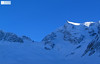


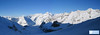


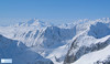
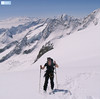
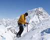


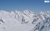
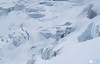
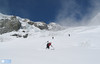


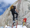
Sattelhorn (Berner Alpen, Oberaletschhütte) is a challenging glacier tour with a very steep section (35-40°).
Peak
- Country
- Switzerland
- Montains
- Berner Alpen / Alpes bernoises
- Tags
- Aletschgletscher Alpes bernoises Berner Alpen / Alpes bernoises Berner Oberland Bernese Alps Oberaletschhütte Schweiz Suisse Switzerland Valais Wallis
- Hut
- Oberaletschhütte
- UTM / CH1903 x ("longitude" E/W)
- 640381
- UTM / CH1903 y ("latitude" N/S)
- 146372
Start point
- Start Point
- Oberaletschhütten
- Altitude
- 2640 m
- UTM / CH1903 x ("longitude" E/W)
- 641142
- UTM / CH1903 y ("latitude" N/S)
- 141641
Conditions
- Avalanche danger
- SLF
- Weather
- meteo.ch meteoschweiz.ch SRF meteoblue.com - Belalp yr.no - Belalp yr.no - Aletschhorn
- Snow report
- bergfex.ch snow-forecast.com schneeradar.de onthesnow.com
- Webcams
- swisswebcams.ch - Belalp Aletschbord swisswebcams.ch - Belalp swisswebcams.ch - Riederalp (Aletsch Arena) swisswebcams.ch - Bettmeralp (Aletsch Arena) swisswebcams.ch - Konkordiahütten
Ski tour map on Sattelhorn


 bivakovací nouzová chata
  cepín a mačky potřeba
 exponovaný, obtížný terén
 horská chata
 hôtel, penzion
 lanovka, vlek
 lavinové nebezpečí, svah > 30°
 ledovcové trhliny
 lehká túra
 mimořádně obtížná túra
 mírně obtížná túra
 obtížná túra
 parkoviště
 přístup k chatě
 restaurace
 sedlo
sedlo sjezd
sjezd skidepo
 vrchol
 výstup
 začátek ledovce
- bivouac, winter room
- crampons & ice axe necessary
- exposed, difficulty terrain
- mountain hut, refuge
- hotel, pension
- cableway, skilift
- avalanche danger, slope > 30°
- glacier cracks
- little difficult tour
- extremely difficult tour
- rather difficult tour
- difficult tour
- parking
- hut acces
- restaurant
- col, pass, saddle
- descent
- skidepot
- peak, summit
- ascent
- glacier beginning
- biwak, winterraum
- steigeisen & pickel erforderlich
- ausgesetzt, schwierige gelände
- berghütte
- hotel, pension
- seilbahn, skilift
- lawinengefahr, hangneigung > 30°
- gletscherspalten
- wenig schwierige tour
- äusserst schwierige tour
- ziemlich schwierige tour
- schwierige tour
- parkplatz
- zugang zur hütte
- restaurant
- sattel, joch, pass
- abfahrt
- skidepot
- gipfel
- aufsieg
- gletscher anfang
- bivacco, locale invernale
- ramponi & piccozza necessari
- esposto, terreno difficolt?
- rifugio, capanna
- alberghi, pensione
- funivia, seggiovia
- pericolo di valanghe, pendenza > 30°
- crepe glacier
- tour piccolo difficile
- tour estremamente difficile
- tour piuttosto difficile
- escursioni difficili
- parcheggio
- accesso capanna
- ristorante
- col, sella, passo, forcella
- discesa
- sci deposito
- picco, vertice, piz
- salita
- inizio ghiacciaio
- bivouac, local d'hiver
- crampons & piolet nécessaire
- exposée, difficulté du terrain
- cabane de montagne, refuge
- hôtel, pension
- téléphérique, téléski
- danger d'avalanche, pente > 30°
- crevasse du glacier
- peu difficile tour
- extr?mement difficile tournée
- assez difficile tour
- difficile tournée
- parking
- acces cabane
- restaurant
- col, selle
- descente
- skis dépôt
- pic, sommet
- ascension
- début glacier
- < 20°
- 20° - 25°
- 25° - 30°
- 30° - 35°
- 35° - 40°
- > 40°
Current weather conditions in the tour area
Planning of ski tour
- Fitness difficulty
-
- ♦♦♦◊
- Technical difficulty
-
- ♦♦♦◊
- best time for this tour
- April-May
- Glacier
- Yes
- Map
- Jungfrau 264 S, 1:50000 Aletschgletscher 1269, 1:25000 Lötschental 1268, 1:25000
- Guides
- Skitouren Berner Alpen Ost
About Ski tour
- Time difficulty
- Ascent (height difference)
- 1300 m
- Lenght of ascent
- 7 km
- Descent (height difference)
- 1300 m
- Total Lenght of tour
- 14 km
- Total time of the tour
- 7-9 h
- Elevation Range
- 2642 - 3745 m
- Principal Aspect
- N S-south, N-north, W-west, E-east
Download
- GPX (track only)
- Sattelhorn_3745m_TRACK.gpx best for display on a detailed topographical map (mapy.cz) or in apps for smartphones (Locus, Garmin Connect, etc.)
- GPX (waipoints, track)
- Sattelhorn.gpx great for uploading in GPS device
- KML (with POI)
- Sattelhorn_3745m_ TOUR.kml for viewing in the Google Earth 3D map application, which you can install on your PC
Current avalanche potential on tour - Sattelhorn

tour Sattelhorn - Reviews
There are no reviews in this section yet. Click the Add Review button to add first review.
Ski tours around Hut Oberaletschhütte, in mountains Berner Alpen / Alpes bernoises, Switzerland
Best ski tours in Berner Alpen / Alpes bernoises by skitour.guru
-

Jungfrau 4158 m
Konkordiahütte Berner Alpen / Alpes bernoises Switzerland
- Length of ascent10 km
- ascent1510 m
- duration6,5-9 h
- Fitness difficulty ♦♦♦◊
- Technical difficulty ♦♦♦◊
Skialpová túra na Jungfrau z chaty Konkordia začíná velmi dlouhým nástupem po ledovci Jungfraufirn. Následuje prudký výstup na hřeben a dále do sedla Rottalsattel přes nepříjemnou thlinu. Skidepot a na mčkách a s cepínem po plochém hřebenu na vrchol. Alternativní sjezd přes sedlo Louwitor na ledovec Aletschfirn a po něm na chatu Konkordia. Možné je po dosažení vrcholu pokračovat na nádraží Jungfraujoch nebo nocovat na Mönchsjochhütte.

-
Vorderes Galmihorn 3507 m
Oberaarjochhütte Berner Alpen / Alpes bernoises Switzerland
- Length of ascent2,5 km
- ascent760 m
- duration4,5-6,5 h
- Fitness difficulty ♦♦◊◊
- Technical difficulty ♦♦♦◊
Vorderes Galmihorn je skvělý skialpový vrchol na závěr akce v centru Bernských Alp. Po výstupu na vrchol z chaty Oberaletschhütte přináší skvělou možnost sjezdu do údolí Goms, což je logisticky výhodné v případě startu lanovkou z Fiesch. Výstup vede po mírném ledovci Galmigletscher a dále po přehledném svahu posetém trhlinami. Při sjezdu dávejte pozor na trhlinu pod sedlem Bächlilicke. Na jaře vás v závěru túry nemine pochod do údolí s lyžemi na batohu. Nabízí se sjezd do Reckingenu nebo Münsteru.
-

Äbeni Flue - Ebnerfluh 3962 m
Hollandiahütte (Lötschenhütte) Berner Alpen / Alpes bernoises Switzerland
- Length of ascent4,5 km
- ascent800 m
- duration3,5-5 h
- Fitness difficulty ♦♦◊◊
- Technical difficulty ♦♦◊◊
Relatively easy glacier ski tour to the most popular summit of the Hollandia hut. The glacier is not too cracked and the ascent path is gradually gaining altitude. At the end, ridge is waiting between the secondary and main summits. With good visibility it is a ski tour without complications.