
 Česky
Česky Deutsch


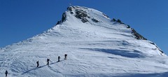
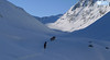
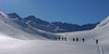


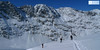
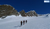
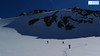


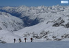

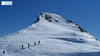


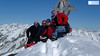
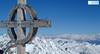
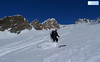
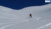
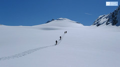
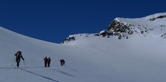
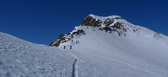
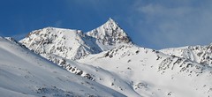
Hinterer Seelenkogel (Langtalereck Hütte, Ötztaler Alpen) is a ski tour between North and South Tyrol. Avalanche danger wait at the beginning of the exit from the Langtal valley.
Peak
- Country
- Austria
- Montains
- Ötztal Alps / Alpi Venoste
- Tags
- Langtalereck Hütte Ötztal Tirol
- Hut
- Langtalereckhütte
- UTM / CH1903 x ("longitude" E/W)
- 32 T 655627
- UTM / CH1903 y ("latitude" N/S)
- 5185515
Start point
- Start Point
- Langtalereckhütte
- Altitude
- 2428 m
- UTM / CH1903 x ("longitude" E/W)
- 32 T 651918
- UTM / CH1903 y ("latitude" N/S)
- 5188046
- village, valley
- Obergurgl
- cableway / lift
- yes, by Steinmannbahn
Conditions
- Avalanche danger
- LWD Tirol
- Weather
- ZAMG ORF wetter.at bergfex.at yr.no - Langtalereckhütte yr.no - Mittl. Seelenkogel yr.no - Schalfkogel
- Snow report
- snow-forecast.com schneeradar.de
- Webcams
- Webcams Travel schneeradar.de
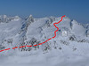
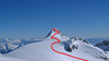
Ski tour map on Hinterer Seelenkogel


 bivakovací nouzová chata
  cepín a mačky potřeba
 exponovaný, obtížný terén
 horská chata
 hôtel, penzion
 lanovka, vlek
 lavinové nebezpečí, svah > 30°
 ledovcové trhliny
 lehká túra
 mimořádně obtížná túra
 mírně obtížná túra
 obtížná túra
 parkoviště
 přístup k chatě
 restaurace
 sedlo
sedlo sjezd
sjezd skidepo
 vrchol
 výstup
 začátek ledovce
- bivouac, winter room
- crampons & ice axe necessary
- exposed, difficulty terrain
- mountain hut, refuge
- hotel, pension
- cableway, skilift
- avalanche danger, slope > 30°
- glacier cracks
- little difficult tour
- extremely difficult tour
- rather difficult tour
- difficult tour
- parking
- hut acces
- restaurant
- col, pass, saddle
- descent
- skidepot
- peak, summit
- ascent
- glacier beginning
- biwak, winterraum
- steigeisen & pickel erforderlich
- ausgesetzt, schwierige gelände
- berghütte
- hotel, pension
- seilbahn, skilift
- lawinengefahr, hangneigung > 30°
- gletscherspalten
- wenig schwierige tour
- äusserst schwierige tour
- ziemlich schwierige tour
- schwierige tour
- parkplatz
- zugang zur hütte
- restaurant
- sattel, joch, pass
- abfahrt
- skidepot
- gipfel
- aufsieg
- gletscher anfang
- bivacco, locale invernale
- ramponi & piccozza necessari
- esposto, terreno difficolt?
- rifugio, capanna
- alberghi, pensione
- funivia, seggiovia
- pericolo di valanghe, pendenza > 30°
- crepe glacier
- tour piccolo difficile
- tour estremamente difficile
- tour piuttosto difficile
- escursioni difficili
- parcheggio
- accesso capanna
- ristorante
- col, sella, passo, forcella
- discesa
- sci deposito
- picco, vertice, piz
- salita
- inizio ghiacciaio
- bivouac, local d'hiver
- crampons & piolet nécessaire
- exposée, difficulté du terrain
- cabane de montagne, refuge
- hôtel, pension
- téléphérique, téléski
- danger d'avalanche, pente > 30°
- crevasse du glacier
- peu difficile tour
- extr?mement difficile tournée
- assez difficile tour
- difficile tournée
- parking
- acces cabane
- restaurant
- col, selle
- descente
- skis dépôt
- pic, sommet
- ascension
- début glacier
- < 20°
- 20° - 25°
- 25° - 30°
- 30° - 35°
- 35° - 40°
- > 40°
Current weather conditions in the tour area
Planning of ski tour
- Fitness difficulty
-
- ♦♦♦◊
- Technical difficulty
-
- ♦♦◊◊
- best time for this tour
- since march
- Glacier
- Yes
- Map
- Gurgl, OEAV 1:25000, Nr. 30/1
- Guides
- Skitourenführer Tirol Ötztal – Silvretta SCHITOUREN-ATLAS ÖSTERREICH WEST
About Ski tour
- Time difficulty
- Ascent (height difference)
- 1140 m
- Lenght of ascent
- 9 km
- Descent (height difference)
- 1140 m
- Total Lenght of tour
- 18 km
- Total time of the tour
- 5-7 h
- Elevation Range
- 2428 - 3475 m
- Principal Aspect
- N, NW S-south, N-north, W-west, E-east
Download
- GPX (track only)
- Hinterer-Seelenkogel-UP-upr.gpx best for display on a detailed topographical map (mapy.cz) or in apps for smartphones (Locus, Garmin Connect, etc.)
- GPX (waipoints, track)
- Hinterer-Seelenkogel_TOUR.gpx great for uploading in GPS device
- KML (with POI)
- Hinterer Seelenkogel 3472 m_TOURmap.kml for viewing in the Google Earth 3D map application, which you can install on your PC
Current avalanche potential on tour - Hinterer Seelenkogel

tour Hinterer Seelenkogel - Reviews
There are no reviews in this section yet. Click the Add Review button to add first review.
Ski tours around Hut Langtalereckhütte, in mountains Ötztal Alps / Alpi Venoste, Austria
-
Annakogel 3336 m
Langtalereckhütte Ötztal Alps / Alpi Venoste Austria
- Length of ascent8 km
- ascent1300 m
- duration5-7 h
- Fitness difficulty ♦♦♦◊
- Technical difficulty ♦♦◊◊
ANNAKOGEL is the lightest tour of the Langtalereck Hütte on the glacier Gurgler Ferner in the Tyrol Ötztaler Alpen. Beautiful view of Schalfkogel and Hohe Wilde.

-

Mittlerer Seelenkogel 3426 m
Langtalereckhütte Ötztal Alps / Alpi Venoste Austria
- Length of ascent5 km
- ascent1000 m
- duration4-5,5 h
- Fitness difficulty ♦♦◊◊
- Technical difficulty ♦♦♦◊
Mittlerer Seelenkogel (Langtalereck Hütte, Ötztaler Alpen) is a rather difficult skitour for his second half. Traverse in steep terrain and the finish can be done under good conditions only.
-

Eiskögele 3228 m
Langtalereckhütte Ötztal Alps / Alpi Venoste Austria
- Length of ascent3 km
- ascent800 m
- duration1,5-2 h
- Fitness difficulty ♦♦◊◊
- Technical difficulty ♦♦♦◊
Eiskögele is a good moderate tour for the last day on the Langtalereckhütte (Ötztaler Alpen). After climbing to the top, you can get off the saddle on the edge of the Obergurgl ski resort and down the slopes to the village.
-

Hohe Wilde / Hochwilde 3461 m
Langtalereckhütte Ötztal Alps / Alpi Venoste Austria
- Length of ascent8 km
- ascent1040 m
- duration6-8 h
- Fitness difficulty ♦♦♦◊
- Technical difficulty ♦♦♦♦
Hohe Wilde (Langtalereck Hütte, Ötztaler Alpen) is a distinctive mountain at the end of the Langtaler Ferner glacier with a challenging finisch to the summit.
-
Schalfkogel E (Langtalereck H.) 3537 m
Langtalereckhütte Ötztal Alps / Alpi Venoste Austria
- Length of ascent7 km
- ascent1500 m
- duration5,5-7 h
- Fitness difficulty ♦♦♦◊
- Technical difficulty ♦♦♦◊
Schalfkogel (Langtalereck Hütte, Ötztaler Alpen) is a relatively demanding tour. After climbing the glacier Gurgler Ferner is a challenging steep steep part of the glacier Kleinleiten Ferner. From the saddle Schalfkogeljoch longer and harder ascent without skis. The mountain is also accessible from Martin Busch Hütte.
Best ski tours in Ötztal Alps / Alpi Venoste by skitour.guru
-
Schalfkogel West (from M.Busch Hut) 3537 m
Martin-Busch-Hütte Ötztal Alps / Alpi Venoste Austria
- Length of ascent7,5 km
- ascent1200 m
- duration4,5-6 h
- Fitness difficulty ♦♦♦◊
- Technical difficulty ♦♦♦◊
Túra na Schalfkogel od chaty Martin Busch Hütte začíná sjezdem do údolí a pokračuje úzkým koridorem pod ledovcovými morénami východním směrem do sedla Schalfkogeljoch. Zde je skidepot a na vrchol v mačkách a s cepínem. Dolů po trase výstupu.
-
Wildspitze - Vernagt Hütte to Vent 3770 m
Vernagthütte Ötztal Alps / Alpi Venoste Austria
- Length of ascent7,5 km
- ascent1100 m
- duration7-9 h
- Fitness difficulty ♦♦♦◊
- Technical difficulty ♦♦♦♦
Trasa výstupu je shodná z túrou z chaty Vernagthütte. Při sjezdu odbočte doleva k sedlu Mitterkarjoch. Velký pozor na trhliny na okraji ledovce. Varianta z ledovce doleva vede strmým, vysněženým svahem. Varianta pravá, přes Mitterkarjoch poskytuje při nižší sněhové pokrývce sestup přes feratu obtížnosti B/C. Po vyjetí ze strmých svahů traverzujtedoleva s co nejmenší ztrátou výšky velkým kotlem k chatě Breslauer. Od chaty zpočátku přes strmý svah k horní stanici lanovky ze skiareálu Vent. Po sjezdovkách dolů na parkoviště. Túra jen pro zkušené alpinisty - výborné lyžaře a schopnosti lézt ve skalním terénu!
-

Weisskugel East, from Hochjoch Hospiz 3739 m
Hochjoch Hospiz Ötztal Alps / Alpi Venoste Austria
- Length of ascent11 km
- ascent1550 m
- duration7-10 h
- Fitness difficulty ♦♦♦♦
- Technical difficulty ♦♦♦◊
Skialpinistická túra na Weisskugel je obtížná především svou délkou. Začátek túry se liší podle sněhové situace. Když je málo sněhu, jde se po rampě, víceméně po vrstevnici k ledovci Hintereisferner. Po ledovci mírně nahoru západním směrem. Prudký je až výšvih do sedla Hintereisjoch, odkud se stoupá doprava, severním směrem k vrcholu. Poslední desítky metrů vedou exponovaným terénem, hodně záleží na množství sněhu.