
 Česky
Česky Deutsch


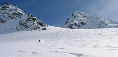


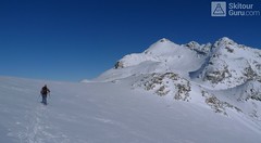
Flüela Wisshorn is the most interesting ski tour around Davos. It is offered to do an interesting round with two great downhills. The north slope to the Jöriseen lakes promises powder, while the south slopes to the Flüelatal valley promise firn. The ascent is not very demanding, at the end to the summit without skis with the help of crampons, then down to Jöriseen and noc once in the nameless saddle. Finally departure to the Flüelatal. Attention, in 2019 there was a landslide of stones in the area of the ascent route, which therefore changes the ascent route.
Peak
- Country
- Switzerland
- Montains
- Albula Alps
- Tags
- Alps 3000 Davos Graubünden Schweiz Switzerland
- Hut
- Davos
- UTM / CH1903 x ("longitude" E/W)
- 793081
- UTM / CH1903 y ("latitude" N/S)
- 182098
Start point
- Start Point
- Tschuggen - parking
- Altitude
- 1694 m
- UTM / CH1903 x ("longitude" E/W)
- 789572
- UTM / CH1903 y ("latitude" N/S)
- 184464
- village, valley
- Flüelatal
- cableway / lift
- no
Conditions
- Avalanche danger
- slf.ch - Institut für Schnee- und Lawinenforschung
- Weather
- Davos / snow-forecast.com Davos / srf.ch Flüela Wisshorn / mountain-forecast.com Pischahorn 2979m / mountain-forecast.com Weissfluh 2843m / mountain-forecast.com Chüpfenflue 2658m/ mountain-forecast.com Pischahorn 3980m/ meteoblue.com Gletscher Ducan 3020m/ mountain-forecast.com Davos / wetter.com Switzerland - animation / srf.ch Flüelapass / srf.ch
- Snow report
- Davos / snow-forecast.com Davos / onthesnow.com Davos - Pischa / bergfex.ch Davos / snow.myswitzerland.com
- Webcams
- Jakobshorn - Davos Strelapass Weissfluhjoch Davos - 17 webcams
Ski tour map on Flüela Wisshorn


 bivakovací nouzová chata
  cepín a mačky potřeba
 exponovaný, obtížný terén
 horská chata
 hôtel, penzion
 lanovka, vlek
 lavinové nebezpečí, svah > 30°
 ledovcové trhliny
 lehká túra
 mimořádně obtížná túra
 mírně obtížná túra
 obtížná túra
 parkoviště
 přístup k chatě
 restaurace
 sedlo
sedlo sjezd
sjezd skidepo
 vrchol
 výstup
 začátek ledovce
- bivouac, winter room
- crampons & ice axe necessary
- exposed, difficulty terrain
- mountain hut, refuge
- hotel, pension
- cableway, skilift
- avalanche danger, slope > 30°
- glacier cracks
- little difficult tour
- extremely difficult tour
- rather difficult tour
- difficult tour
- parking
- hut acces
- restaurant
- col, pass, saddle
- descent
- skidepot
- peak, summit
- ascent
- glacier beginning
- biwak, winterraum
- steigeisen & pickel erforderlich
- ausgesetzt, schwierige gelände
- berghütte
- hotel, pension
- seilbahn, skilift
- lawinengefahr, hangneigung > 30°
- gletscherspalten
- wenig schwierige tour
- äusserst schwierige tour
- ziemlich schwierige tour
- schwierige tour
- parkplatz
- zugang zur hütte
- restaurant
- sattel, joch, pass
- abfahrt
- skidepot
- gipfel
- aufsieg
- gletscher anfang
- bivacco, locale invernale
- ramponi & piccozza necessari
- esposto, terreno difficolt?
- rifugio, capanna
- alberghi, pensione
- funivia, seggiovia
- pericolo di valanghe, pendenza > 30°
- crepe glacier
- tour piccolo difficile
- tour estremamente difficile
- tour piuttosto difficile
- escursioni difficili
- parcheggio
- accesso capanna
- ristorante
- col, sella, passo, forcella
- discesa
- sci deposito
- picco, vertice, piz
- salita
- inizio ghiacciaio
- bivouac, local d'hiver
- crampons & piolet nécessaire
- exposée, difficulté du terrain
- cabane de montagne, refuge
- hôtel, pension
- téléphérique, téléski
- danger d'avalanche, pente > 30°
- crevasse du glacier
- peu difficile tour
- extr?mement difficile tournée
- assez difficile tour
- difficile tournée
- parking
- acces cabane
- restaurant
- col, selle
- descente
- skis dépôt
- pic, sommet
- ascension
- début glacier
- < 20°
- 20° - 25°
- 25° - 30°
- 30° - 35°
- 35° - 40°
- > 40°
Current weather conditions in the tour area
Planning of ski tour
- Fitness difficulty
-
- ♦♦◊◊
- Technical difficulty
-
- ♦♦♦◊
- best time for this tour
- Februar-April
- Glacier
- No
- Map
- 1197 Davos, Swisstopo 1:25000 S258 Bergün-Bravuogn, Swisstopo 1:50000
- Guides
- Graubünden Süd / SAC-CAS.ch, deutsch Die klassischen Skitouren / SAC-CAS.ch, deutsch Les classiques de randonnée à ski / SAC-CAS.ch, francais Rund um Davos / Rother, deutsch
About Ski tour
- Time difficulty
- Ascent (height difference)
- 1360 m
- Lenght of ascent
- 6,5 km
- Descent (height difference)
- 1360 m
- Total Lenght of tour
- 12,5 km
- Total time of the tour
- 5,5-7 h
- Elevation Range
- 1964 - 3085 m
- Principal Aspect
- NW, N, W, SW S-south, N-north, W-west, E-east
Download
- GPX (track only)
- Fluela-Wisshorn-TRK.gpx best for display on a detailed topographical map (mapy.cz) or in apps for smartphones (Locus, Garmin Connect, etc.)
- GPX (waipoints, track)
- Fluela-Wissshorn_3085_Davos_skitour.gpx great for uploading in GPS device
- KML (with POI)
- Fluela-Wissshorn_3085_Davos_skitour.kml for viewing in the Google Earth 3D map application, which you can install on your PC
Current avalanche potential on tour - Flüela Wisshorn

tour Flüela Wisshorn - Reviews
There are no reviews in this section yet. Click the Add Review button to add first review.
Ski tours around Hut Davos, in mountains Albula Alps, Switzerland
-

Isentällispitz 2985 m
Davos Albula Alps Switzerland
- Length of ascent4 km
- ascent1050 m
- duration3-4,5 h
- Fitness difficulty ♦♦◊◊
- Technical difficulty ♦♦◊◊
Isentällispitz is another enjoyable ski tour starting in the Flüelatal valley. From the Tschuggen parking lot, ascend over wide slopes to the saddle, where the ski depot is located. From there, continue with crampons to the panoramic summit. The descent follows the ascent route.

-

Isenfürggli 2765 m
Davos Albula Alps Switzerland
- Length of ascent3 km
- ascent845 m
- duration2,5-3,5 h
- Fitness difficulty ♦♦◊◊
- Technical difficulty ♦♦◊◊
The ascent to the Isenfürggli saddle is a worthwhile addition after successful descents from Pischahorn or Isentällispitz. Especially in firn conditions or fresh powder, it is a rewarding destination. From the saddle, there is a beautiful view of the Silvretta range, with the striking Piz Linard as its centerpiece.
-

Weissfluh - Chörbhorn - Schatzalp 2845 m
Davos Albula Alps Switzerland
- Length of ascent1,5 km
- ascent430 m
- duration3-4 h
- Fitness difficulty ♦♦◊◊
- Technical difficulty ♦♦◊◊
Interesting freetouring that takes advantage of the opportunity to take the cable car from the Parsenn area to almost 3000 meters in altitude. After descending along the southeastern line of Weissfluh, an easy freeride follows in the direction of Strelapass. The difficulty is influenced by the passability of the gallery – see photo. With a short ascent to the summit of Chörbhorn, you gain space for a descent through pristine snow. Then, you continue via the piste to the Schatzalp cog railway station and further down the toboggan run to Davos, where a bus or train is available.
-

Gletscher Ducan 3019 m
Davos Albula Alps Switzerland
- Length of ascent6,5 km
- ascent1360 m
- duration5,5-7 h
- Fitness difficulty ♦♦◊◊
- Technical difficulty ♦♦♦◊
The Ducan Gletscher is a summit with a wonderful view of the Piz Kesch and especially the Piz Ela. The ski tour starts in Monstein, where the highest brewery in Europe is located. The Fanezfurgga saddle leads to valley with a striking mountain. The end of the climb up is usually with ice axe and crampons. The descent through the Ducantal valley is oriented to the north and leads skiers into the Sertigtal valley. The route can also be done in the opposite direction. It is advisable to undertake the tour with the support of public transport.
-

Pischahorn 2980 m
Davos Albula Alps Switzerland
- Length of ascent1,5-2 km
- ascent585 m
- duration3-4 h
- Fitness difficulty ♦♦◊◊
- Technical difficulty ♦♦◊◊
Pohodová túra na Pischahorn s krásným výhledem na údolí Davosu. S podporou lanovky je to na vrchol pouhých 500 výškových metrů. Sjezd má díky šířce svahu mnoho variant.
Best ski tours in Albula Alps by skitour.guru
-

Piz d´Err 3378 m
Chamanna Jenatsch / Jenatschhütte Albula Alps Switzerland
- Length of ascent km
- ascent m
- duration h
- Fitness difficulty ♦♦◊◊
- Technical difficulty ♦♦◊◊
Piz d´Err is a popular ski tour to the panoramic summit. The technically undemanding ski tour begins in Chamanna Jenatsch. The only steep section is climbing on the summit. A first class experience is under stable conditions the descent to the opposite side, western slopes to Surselva, more precisely to the village Sur, a total of 1,800 m.
-

Piz Kesch - Chamanna Kesch 3417 m
Keschhütte / Chamanna digl Kesch Albula Alps Switzerland
- Length of ascent4,5 km
- ascent845 m
- duration4,5-6 h
- Fitness difficulty ♦♦◊◊
- Technical difficulty ♦♦♦◊
Piz Kesch is a well-known mountain in the Albula Alps region, Piz Kesch clearly falls on the surrounding mountains. The view of Kesch can be enjoyed from Bernina, Muragl and other peaks. The ascent to the ski depot is easy. You go on / climb with an ice axe and crampons. The exposed terrain in places, the difficulty depends on the current snow conditions. Rope protection is usually not necessary. A perfect panoramic view from above.
-
Piz Calderas 3397 m
Chamanna Jenatsch / Jenatschhütte Albula Alps Switzerland
- Length of ascent km
- ascent745 m
- duration2,5-4 h
- Fitness difficulty ♦♦◊◊
- Technical difficulty ♦♦♦◊
Piz Calderas is a popular peak above Chamanna Jenatsch. From the valley above the hut turn left onto the northern slope of the glacier Vadret Calderas. Followed by travers to the glacial mulch and at the end of the southeast slope to the top. Downhill along the exit route.