
 Česky
Česky Deutsch


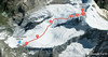


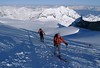

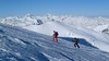
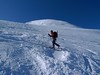


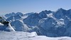


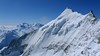


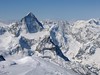

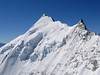

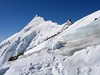
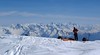


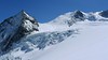

Bishorn seems to be a relatively light 4000, but looks are deceptive. If you include the approach to Cabane Tracuit from Zinal in the ascent, it is quite a long ski tour. From the hut the ascent line leads slightly up the glacier Turtmanngletscher. Directly below the peak on the plateau you have to swap skis for crampons and comfortably climb to the panoramic summit - one of the best in all of Valais. Driving down the northern slope is usually a fantastic enjoyment, the risk of glacier cracks is minimal.
Peak
- Country
- Switzerland
- Montains
- Walliser Alpen / Alpes valaisannes
- Tags
- Haute Route Imperial Schweiz Switzerland Tour du Ciel Val d’Anniviers Valais Wallis Zinal
- Hut
- Cabane Tracuit
- UTM / CH1903 x ("longitude" E/W)
- 618605
- UTM / CH1903 y ("latitude" N/S)
- 108780
Start point
- Start Point
- Cabane Tracuit
- Altitude
- 3256 m
- UTM / CH1903 x ("longitude" E/W)
- 618620
- UTM / CH1903 y ("latitude" N/S)
- 108770
Conditions
- Avalanche danger
- www.slf.ch
- Weather
- SRF Meteo Meteoschweiz Zinal, snow-forecast.com Cabane Tracuit, meteoblue.com Blanc Moming 3663 / mountain-forecast.com Les Diablons 3609 m / mountain-forecast.com Bishorn 4153 / mountain-forecast.com Üssers Barrhorn 3610, mountain-forecast.com Schweiz TV - animation Bergwetter / alpenverein.at Zinal, meteoblue.com
- Snow report
- Zinal, snow-forecast.com Zinal, bergfex.ch Zinal, onthesnow.com Zinal, skiresort.info snow.myswitzerland.com/
- Webcams
- Cabane Tracuit Zinal webcams
Ski tour map on Bishorn


 bivakovací nouzová chata
  cepín a mačky potřeba
 exponovaný, obtížný terén
 horská chata
 hôtel, penzion
 lanovka, vlek
 lavinové nebezpečí, svah > 30°
 ledovcové trhliny
 lehká túra
 mimořádně obtížná túra
 mírně obtížná túra
 obtížná túra
 parkoviště
 přístup k chatě
 restaurace
 sedlo
sedlo sjezd
sjezd skidepo
 vrchol
 výstup
 začátek ledovce
- bivouac, winter room
- crampons & ice axe necessary
- exposed, difficulty terrain
- mountain hut, refuge
- hotel, pension
- cableway, skilift
- avalanche danger, slope > 30°
- glacier cracks
- little difficult tour
- extremely difficult tour
- rather difficult tour
- difficult tour
- parking
- hut acces
- restaurant
- col, pass, saddle
- descent
- skidepot
- peak, summit
- ascent
- glacier beginning
- biwak, winterraum
- steigeisen & pickel erforderlich
- ausgesetzt, schwierige gelände
- berghütte
- hotel, pension
- seilbahn, skilift
- lawinengefahr, hangneigung > 30°
- gletscherspalten
- wenig schwierige tour
- äusserst schwierige tour
- ziemlich schwierige tour
- schwierige tour
- parkplatz
- zugang zur hütte
- restaurant
- sattel, joch, pass
- abfahrt
- skidepot
- gipfel
- aufsieg
- gletscher anfang
- bivacco, locale invernale
- ramponi & piccozza necessari
- esposto, terreno difficolt?
- rifugio, capanna
- alberghi, pensione
- funivia, seggiovia
- pericolo di valanghe, pendenza > 30°
- crepe glacier
- tour piccolo difficile
- tour estremamente difficile
- tour piuttosto difficile
- escursioni difficili
- parcheggio
- accesso capanna
- ristorante
- col, sella, passo, forcella
- discesa
- sci deposito
- picco, vertice, piz
- salita
- inizio ghiacciaio
- bivouac, local d'hiver
- crampons & piolet nécessaire
- exposée, difficulté du terrain
- cabane de montagne, refuge
- hôtel, pension
- téléphérique, téléski
- danger d'avalanche, pente > 30°
- crevasse du glacier
- peu difficile tour
- extr?mement difficile tournée
- assez difficile tour
- difficile tournée
- parking
- acces cabane
- restaurant
- col, selle
- descente
- skis dépôt
- pic, sommet
- ascension
- début glacier
- < 20°
- 20° - 25°
- 25° - 30°
- 30° - 35°
- 35° - 40°
- > 40°
Current weather conditions in the tour area
Planning of ski tour
- Fitness difficulty
-
- ♦♦♦◊
- Technical difficulty
-
- ♦♦◊◊
- best time for this tour
- March-May
- Glacier
- Yes
- Map
- Arolla 283 S, Swisstopo 1:50000 Montana 273 S, Swisstopo 1:50000 Evolene 1327, Swisstopo 1:25000 Vissoie 1307, Swisstopo 1:25000 St. Niklaus 1308, Swisstopo 1:25000
- Guides
- Ski de randonnée Bas-Valais Die klassischen Skitouren (SAC, deutsch) Les classiques de randonnée à ski (SAC, francais) Walliser Alpen (Rother, deutsch)
About Ski tour
- Time difficulty
- Ascent (height difference)
- 950 m
- Lenght of ascent
- 4,5 km
- Descent (height difference)
- 950 m
- Total Lenght of tour
- 9 km
- Total time of the tour
- 5-6,5 h
- Elevation Range
- 3520 - 4153 m
- Principal Aspect
- W, NW S-south, N-north, W-west, E-east
Download
- GPX (track only)
- Bishorn_Tracuit-Hut_TRK.gpx best for display on a detailed topographical map (mapy.cz) or in apps for smartphones (Locus, Garmin Connect, etc.)
- GPX (waipoints, track)
- Bishorn_Tracuit-Hut_skitour.gpx great for uploading in GPS device
- KML (with POI)
- Bishorn_TracuitHut_skitour Guru.kml for viewing in the Google Earth 3D map application, which you can install on your PC
Video of tour on Bishorn
Current avalanche potential on tour - Bishorn

tour Bishorn - Reviews
There are no reviews in this section yet. Click the Add Review button to add first review.
Ski tours around Hut Cabane Tracuit, in mountains Walliser Alpen / Alpes valaisannes, Switzerland

Best ski tours in Walliser Alpen / Alpes valaisannes by skitour.guru
-

Alphubel 4206 m
Britannia Hütte Walliser Alpen / Alpes valaisannes Switzerland
- Length of ascent10 km
- ascent1450 m
- duration7-10 h
- Fitness difficulty ♦♦♦◊
- Technical difficulty ♦♦♦◊
ALPHUBEL (Britannia Hütte, Walliser Alpen) is seemingly lighter 4000vka, but over are dangerous glacial cracks. Ski alpinists can also go from the Saas Fee ski area, most not far from the cable car station Langfluh .

-

Tour du Ciel - day 5 3030 m
Turtmannhütte / Cabane Tourtemagne Walliser Alpen / Alpes valaisannes Switzerland
- Length of ascent5,5 km
- ascent1110 m
- duration5-7 h
- Fitness difficulty ♦♦◊◊
- Technical difficulty ♦♦◊◊
A relatively easy ascent, though steep in places, from Lake Turtmannsee, which is reached by descending from the Turtmannhütte. From the summit ridge, there's a long descent to the Hotel Weisshorn, followed by forest trails leading down to the village of St. Luc - Chandolin in the Val d'Anniviers.
-

La Luette 3547 m
Cabane des Dix Walliser Alpen / Alpes valaisannes Switzerland
- Length of ascent3 km
- ascent710 m
- duration1,5-3 h
- Fitness difficulty ♦♦◊◊
- Technical difficulty ♦♦◊◊
La Luette je vděčná túra z chaty Cabane Dix. Po mírném svahu na ledovec Glacier de la Luette a v závěru po hřebenu na vrchol. Pouhých 500 výškových metrů od chaty může být lákadlem pro odpolední túru poté, když dorazíte brzo na chatu Dix.