
 Česky
Česky Deutsch


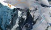
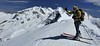
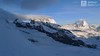

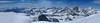


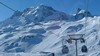


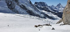
Breithorn can be rated as the lightest 4000 in the Alps. In any case, thanks to the support of the Klein Matterhorn cable car, which transports ski mountaineers up to 3880 m. From the cable car station (beautiful viewpoint) to the glacier plain below the summit, which can be often reached on skis. In good conditions, it is worthwhile to continue to the Schwarztor saddle and drive descent back to Zermatt. The second variant of the freeride is the descent from the Unterer Theodulgletscher. This descent is simply great up to Seehöre 2400.
Peak
- Country
- Switzerland
- Montains
- Walliser Alpen / Alpes valaisannes
- Tags
- Alpes valaisannes Alps 4000 Mattertal Monte Rosa Hütte Valais Wallis Walliser Alpen Zermatt
- Hut
- Monte Rosa Hütte
- UTM / CH1903 x ("longitude" E/W)
- 624635
- UTM / CH1903 y ("latitude" N/S)
- 87494
Start point
- Start Point
- Klein Matterhorn
- Altitude
- 3880 m
- UTM / CH1903 x ("longitude" E/W)
- 622528
- UTM / CH1903 y ("latitude" N/S)
- 87348
- village, valley
- Zermatt
- cableway / lift
- Zermatt - Trockener Steg - Klein Matterhorn
Conditions
- Avalanche danger
- SLF - Institut für Schnee- und Lawinenforschung
- Weather
- Monte Rosa Hütte / meteoblue.com Gornergrat 3130m / meteocentrale.ch Klein Matterhorn 3880m / mountain-forecast.com Gornergrat 3130m / mountain-forecast.com Ludwigshöhe 4344m / mountain-forecast.com Breithorn 4160m / mountain-forecast.com Lyskamm 4527m / mountain-forecast.com Schweiz / meteo.ch Schweiz TV - animation Bergwetter / alpenverein.at Zermatt / kachelmannwetter.com
- Snow report
- Zermatt / snow-forecast.com Zermatt / onthesnow.com Zermatt / http://snow.myswitzerland.com/
- Webcams
- Zermatt - Gornergrat Zermatt - Bahnhof Zermatt - 29 webcams
Ski tour map on Breithorn - Zermatt


 bivakovací nouzová chata
  cepín a mačky potřeba
 exponovaný, obtížný terén
 horská chata
 hôtel, penzion
 lanovka, vlek
 lavinové nebezpečí, svah > 30°
 ledovcové trhliny
 lehká túra
 mimořádně obtížná túra
 mírně obtížná túra
 obtížná túra
 parkoviště
 přístup k chatě
 restaurace
 sedlo
sedlo sjezd
sjezd skidepo
 vrchol
 výstup
 začátek ledovce
- bivouac, winter room
- crampons & ice axe necessary
- exposed, difficulty terrain
- mountain hut, refuge
- hotel, pension
- cableway, skilift
- avalanche danger, slope > 30°
- glacier cracks
- little difficult tour
- extremely difficult tour
- rather difficult tour
- difficult tour
- parking
- hut acces
- restaurant
- col, pass, saddle
- descent
- skidepot
- peak, summit
- ascent
- glacier beginning
- biwak, winterraum
- steigeisen & pickel erforderlich
- ausgesetzt, schwierige gelände
- berghütte
- hotel, pension
- seilbahn, skilift
- lawinengefahr, hangneigung > 30°
- gletscherspalten
- wenig schwierige tour
- äusserst schwierige tour
- ziemlich schwierige tour
- schwierige tour
- parkplatz
- zugang zur hütte
- restaurant
- sattel, joch, pass
- abfahrt
- skidepot
- gipfel
- aufsieg
- gletscher anfang
- bivacco, locale invernale
- ramponi & piccozza necessari
- esposto, terreno difficolt?
- rifugio, capanna
- alberghi, pensione
- funivia, seggiovia
- pericolo di valanghe, pendenza > 30°
- crepe glacier
- tour piccolo difficile
- tour estremamente difficile
- tour piuttosto difficile
- escursioni difficili
- parcheggio
- accesso capanna
- ristorante
- col, sella, passo, forcella
- discesa
- sci deposito
- picco, vertice, piz
- salita
- inizio ghiacciaio
- bivouac, local d'hiver
- crampons & piolet nécessaire
- exposée, difficulté du terrain
- cabane de montagne, refuge
- hôtel, pension
- téléphérique, téléski
- danger d'avalanche, pente > 30°
- crevasse du glacier
- peu difficile tour
- extr?mement difficile tournée
- assez difficile tour
- difficile tournée
- parking
- acces cabane
- restaurant
- col, selle
- descente
- skis dépôt
- pic, sommet
- ascension
- début glacier
- < 20°
- 20° - 25°
- 25° - 30°
- 30° - 35°
- 35° - 40°
- > 40°
Current weather conditions in the tour area
Planning of ski tour
- Fitness difficulty
-
- ♦♦♦◊
- Technical difficulty
-
- ♦♦♦◊
- best time for this tour
- March-May
- Glacier
- Yes
- Map
- Mischabel 284 S, Swisstopo 1:50000 Zermatt 1348, Swisstopo 1:25000
- Guides
- Walliser Alpen Ost / SAC, deutsch Die klassischen Skitouren (SAC, deutsch) Les classiques de randonnée à ski (SAC, francais) Walliser Alpen (Rother, deutsch)
About Ski tour
- Time difficulty
- Ascent (height difference)
- 440 m
- Lenght of ascent
- 3 km
- Descent (height difference)
- 2500 m
- Total Lenght of tour
- 12 km
- Total time of the tour
- 3-4 h
- Elevation Range
- 3880 - 4164 m
- Principal Aspect
- W, SW, S S-south, N-north, W-west, E-east
Download
- GPX (track only)
- Breithorn_KleinMatterhorn_TRK.gpx best for display on a detailed topographical map (mapy.cz) or in apps for smartphones (Locus, Garmin Connect, etc.)
- GPX (waipoints, track)
- Breithorn_KlMatterhorn_skitour.gpx great for uploading in GPS device
- KML (with POI)
- Breithorn_KleinMatterhorn_skitour.kml for viewing in the Google Earth 3D map application, which you can install on your PC
tour Breithorn - Zermatt - Reviews
There are no reviews in this section yet. Click the Add Review button to add first review.
Ski tours around Hut Monte Rosa Hütte, in mountains Walliser Alpen / Alpes valaisannes, Switzerland
-

Nordend - Monte Rosa 4609 m
Monte Rosa Hütte Walliser Alpen / Alpes valaisannes Switzerland
- Length of ascent7 km
- ascent1745 m
- duration10-12,5 h
- Fitness difficulty ♦♦♦♦
- Technical difficulty ♦♦♦♦
Nordend is a very challenging glacier ski tour to an important summit in the Monte Rosa massif. The biggest problem is the huge crevasses, due to which the ascent and descent route has to be adjusted. Relevant information about this is available in the Monte Rosa Hut. Only creviasses make difficult the ascent to the saddle Silbersattel, further up the ascent without skis (crampons + ice axe) bends along a relatively exposed slope to the summit. The descent is fantastic, but watch out for cracks again. Simply put, challenging ski tour!

-
Signalkuppe / Punta Gnifetti 4554 m
Monte Rosa Hütte Walliser Alpen / Alpes valaisannes Switzerland
- Length of ascent8,5 km
- ascent1680 m
- duration9-10,5 h
- Fitness difficulty ♦♦♦◊
- Technical difficulty ♦♦♦◊
Signalkuppe / Punta Gnifetti is the highest peak in the Alps that can be climbed on skis. At the top, you can sleep in the winter room of the highest mountain hut in the Alps - Capanna Margherita (CAI). From the top is a fantastic view of the Italian part of the Alps. In the first half of this long ski tour, watch out for numerous crevasses. The rest of the ski tour over the glacier Grenzgletscher is technically easy and there is no steep passage along the entire route. This ski mountain tour is practically impossible during low-snow winters - inquire at the Monte Rosa Hut.
-

Dufourspitze / Punta Dufour - Monte Rosa 4634 m
Monte Rosa Hütte Walliser Alpen / Alpes valaisannes Switzerland
- Length of ascent6,5 km
- ascent1760 m
- duration9-11,5 h
- Fitness difficulty ♦♦♦♦
- Technical difficulty ♦♦♦♦
Dufourspitze / Punta Dufour je nejvyšším vrcholem Švýcarska v masivu Monte Rosa. Skialpinistická túra na vrchol je až do výšky 4000 m shodná s výstupem na Norden. Trasa na Dufourspitze se pak stáčí jižním směrem na ledovec Satteltolle na odtud bez lyží po hřebeni na vrchol. Původní trasa výstupu ze sedla Silbersattel je od roku 2019 nelezitelná, fixní lana byla odstraněna.
Best ski tours in Walliser Alpen / Alpes valaisannes by skitour.guru
-

Alphubel 4206 m
Britannia Hütte Walliser Alpen / Alpes valaisannes Switzerland
- Length of ascent10 km
- ascent1450 m
- duration7-10 h
- Fitness difficulty ♦♦♦◊
- Technical difficulty ♦♦♦◊
ALPHUBEL (Britannia Hütte, Walliser Alpen) is seemingly lighter 4000vka, but over are dangerous glacial cracks. Ski alpinists can also go from the Saas Fee ski area, most not far from the cable car station Langfluh .
-

Tour du Ciel - day 4 4153 m
Cabane Tracuit Walliser Alpen / Alpes valaisannes Switzerland
- Length of ascent6 km
- ascent1150 m
- duration5,5-7,5 h
- Fitness difficulty ♦♦♦◊
- Technical difficulty ♦♦♦◊
The stage begins at the Cabane Tracuit with an ascent of the 4,000-meter peak Bishorn, which is considered relatively easy. After skiing back down to the Tracuit hut, the route continues with a descent over the Turtmanngletscher glacier. A subsequent climb over the Brunegggletscher glacier leads into a rocky corridor, which marks the beginning of the descent to the Turtmannhütte.
-

La Luette 3547 m
Cabane des Dix Walliser Alpen / Alpes valaisannes Switzerland
- Length of ascent3 km
- ascent710 m
- duration1,5-3 h
- Fitness difficulty ♦♦◊◊
- Technical difficulty ♦♦◊◊
La Luette je vděčná túra z chaty Cabane Dix. Po mírném svahu na ledovec Glacier de la Luette a v závěru po hřebenu na vrchol. Pouhých 500 výškových metrů od chaty může být lákadlem pro odpolední túru poté, když dorazíte brzo na chatu Dix.