
 Česky
Česky Deutsch


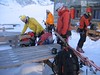


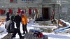


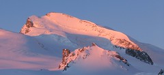
The classic mountain hut Schönbielhütte rises on the terrace above the Zmutt glacier. Nice view of the north face of the Matterhorn and the Monte Rosa massif on the horizon. Ski tours to Tete Blanche and Tete Valpelline start from the hut. The demanding crossing of the Haute Route Imperiale, french Tour du Ciel named, begins at Schönbielhütte. As part of the stage to Cabane Mountet you can turn to Mont Durand. The easiest access to the Schönbielhütte is from the Schwarzsee cable car station, you can also start from Zermatt or from the Furi cable car intermediate station.
Tours starting from hut
Ski tours around Hut Schönbielhütte
-
Mont Durand / Arbenhorn 3713 m
Schönbielhütte Walliser Alpen / Alpes valaisannes Switzerland
- Length of ascent5,5 km
- ascent1630 m
- duration7-10 h
- Fitness difficulty ♦♦♦◊
- Technical difficulty ♦♦♦◊
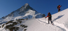
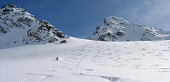
Mont Durand, also known as the Arbenhorn, is a great panoramic point. Matterhorn on one side, Dent Blanche on the other. From the Schönbielhütte an early morning descent on the edge of the moraine to the plateau Hohle Bielen. On a sunny day it is necessary to overcome the steep slope below the Schönbielhorn in good time. More precisely above the edge of the Hohwäng glacier up to an altitude of 3200 m. Continue with a slight ascent along this glacier in a northeastern direction above the level of the Col Durand saddle. Until the height to which it is possible to climb on skis and with crampons and ice ax on a relatively exposed slope to the summit. If you follow the ascent route, watch out for avalanches and snow slides that come from the Schönbielhorn in the afternoon sun.

-

Tour du Ciel - day 2 3404 m
Schönbielhütte Walliser Alpen / Alpes valaisannes Switzerland
- Length of ascent5 km
- ascent1190 m
- duration5-7 h
- Fitness difficulty ♦♦♦◊
- Technical difficulty ♦♦♦◊
Tour du Ciel (known as the reverse direction of the Haute Route Impériale) begins with the first real stage from the Schönbiel Hut, featuring a descent along the edge of the moraine. This is followed by a long, steep climb over glacier seracs, ideally tackled in the early morning. The subsequent ascent over the Hohlwäng Glacier to the Col Durand (3404 m) is then straightforward. An alternative is to turn right before the pass and climb Mont Durand. From the pass, descend over the Glacier Durand, followed by a short climb to the Cabane Mountet.
-

Tour du Ciel - day 1 2695 m
Schönbielhütte Walliser Alpen / Alpes valaisannes Switzerland
- Length of ascent6,5 km
- ascent650 m
- duration4-5,5 h
- Fitness difficulty ♦♦♦◊
- Technical difficulty ♦♦◊◊
The high-altitude crossing Tour du Ciel begins in Zermatt and ends in the Val d’Anniviers, running from north to south. The first stage starts in Zermatt; for better acclimatization, it is recommended to spend the night at the Schönbiel Hut – possibly combined with an ascent of the Tête Blanche. The easiest version of the route begins at the upper station of the Schwarzsee cable car.
- Country
- Switzerland
- Montains
- Walliser Alpen / Alpes valaisannes
- Open (winter)
- mid March - mid May
- Beds
- 70
- Winterraum
- yes, 12 beds
- Shortening of access (cableway, lift, taxi, snowcat...)
- yes, from Zermatt to Furi or Schwarzsee
- Luggage transport
- no
- Card Pay
- yes
- Shower
- no
- Wifi
- no
- UTM / CH1903 x ("longitude" E/W)
- 614746
- UTM / CH1903 y ("latitude" N/S)
- 94503
- GPX access to hut (waipoints, track)
- Schönbielhütte_all_access.gpx
- GPX access to hut (track only)
- Schoenbiel-Hut_all_access_TRK.gpx
- Map
- Arolla 283 S, Swisstopo 1:50000 Matterhorn 1347, Swisstopo 1:25000 Zermatt 1348, Swisstopo 1:25000
- Guides
- Ski de randonnée Bas-Valais Die klassischen Skitouren (SAC, deutsch) Les classiques de randonnée à ski (SAC, francais) Walliser Alpen (Rother, deutsch)
- Phone (hut)
- +41 27 967 13 54
- Phone (valley)
- -
- Cell phone
- +41 (0)79 639 41 28
- Mobile Signal
- yes
- Web
- schoenbielhuette.ch
- bielti.zermatt@gmx.ch
- Owner of hut
- SAC Monte Rosa
- Schönbielhütte
- Reservation
- online former
- Online reservation
- alpsonline.org
- Start Point
- Zermatt - ZenStecken
- UTM / CH1903 x ("longitude" E/W)
- 622740
- UTM / CH1903 y ("latitude" N/S)
- 94493
- Altitude
- 1614 m
- Ascent (height difference)
- 1080 m
- Time of Access
- 4-5 h
- Shortening lift
- no
- Start Point
- Schwarzsee - cable car station
- UTM / CH1903 x ("longitude" E/W)
- 620948
- UTM / CH1903 y ("latitude" N/S)
- 93430
- Altitude
- 3726 m
- Ascent (height difference)
- 700 m
- Time of Access
- 3-4 h
- Shortening lift
- yes, by cable car Zermatt - Furi - Schwarzsee
- Avalanche danger
- www.slf.ch
- Weather
- SRF Meteo Meteoschweiz Zermatt, snow-forecast.com Klein Matterhorn, meteoblue.com Wandfluehorn 3589 / mountain-forecast.com Tete Blanche 3750m / mountain-forecast.com Tete Valpelline 3798m / mountain-forecast.com Mont Durand, mountain-forecast.com Schweiz TV - animation Bergwetter / alpenverein.at Zermatt / kachelmannwetter.com Gornergrat 3130m / meteocentrale.ch
- Snow report
- Zermatt, snow-forecast.com Zermatt, bergfex.ch Zermatt, onthesnow.com Zermatt, skiresort.info snow.myswitzerland.com/
- Webcams
- Zermatt - Schwarzsee Zermatt - Bahnhof Zermatt - 29 webcams
- Region
- Zermatt Wallis.ch
- Public traffic
- train SBB bus - Postauto.ch
- Skiresort nearby
- Zermatt, matterhornparadise.ch
- Other links
- Swiss Tourism
hut Schönbielhütte - Reviews
There are no reviews in this section yet. Click the Add Review button to add first review.
Best ski tours in mountains Walliser Alpen / Alpes valaisannes, Switzerland
-

Col Valpelline, Day 6 H.R. Chamonix-Zermatt 3551 m
Cabane des Vignettes Walliser Alpen / Alpes valaisannes Switzerland
- Length of ascent9 km
- ascent1485 m
- duration8-10 h
- Fitness difficulty ♦♦♦◊
- Technical difficulty ♦♦♦◊
The last stage of the Haute Route Chamonix - Zermatt is an ode to skiing. After an easy ascent to three saddles - Col de Eveque, Col du Mont Brulé and Col Valpelline. Every ski mountaineer will be amazed by the panorama of the impressive 4000m peaks - Dent Blanche, Matterhorn and Dent d´Hérens. This is followed by a 10 km descent to Zermatt.
-
Strahlhorn 4190 m
Britannia Hütte Walliser Alpen / Alpes valaisannes Switzerland
- Length of ascent9,4 km
- ascent1250 m
- duration6-8 h
- Fitness difficulty ♦♦♦◊
- Technical difficulty ♦♦◊◊
Strahlhorn (Britannia Hütte, Walliser Alpen) is a classic glacier ski tour from Britannia Hütte. From the Adlerpass saddle, you usually go skiing to the top. To get off Saas Fee, take the Metro to the "window" at 3460 m to the Hohlaub Gletscher and start the ascent after a short ride.
-

Tour du Ciel - day 5 3030 m
Turtmannhütte / Cabane Tourtemagne Walliser Alpen / Alpes valaisannes Switzerland
- Length of ascent5,5 km
- ascent1110 m
- duration5-7 h
- Fitness difficulty ♦♦◊◊
- Technical difficulty ♦♦◊◊
A relatively easy ascent, though steep in places, from Lake Turtmannsee, which is reached by descending from the Turtmannhütte. From the summit ridge, there's a long descent to the Hotel Weisshorn, followed by forest trails leading down to the village of St. Luc - Chandolin in the Val d'Anniviers.
Best ski tours in Switzerland by skitour.guru
-

Isentällispitz 2985 m
Davos Albula Alps Switzerland
- Length of ascent4 km
- ascent1050 m
- duration3-4,5 h
- Fitness difficulty ♦♦◊◊
- Technical difficulty ♦♦◊◊
Isentällispitz is another enjoyable ski tour starting in the Flüelatal valley. From the Tschuggen parking lot, ascend over wide slopes to the saddle, where the ski depot is located. From there, continue with crampons to the panoramic summit. The descent follows the ascent route.
-

Chli Bielenhorn 2940 m
Andermatt - Realp - Oberalppass Urner Alps Switzerland
- Length of ascent8,5 km
- ascent1450 m
- duration5-6,5 h
- Fitness difficulty ♦♦♦◊
- Technical difficulty ♦♦◊◊
Chli Bielenhorn je skalnatá špička v říši monumentálních žulových stěn divokých hor. Začátek kolem silnice na Furkapass pokračuje po pláni pod chatou Albert-Heim-Hütte. Pak přichází v sousedství pohled na ledovce monumentálního Dammastocku. V kulisách skal vede logická linie ke skidepu kousek pod vrcholem. V případě stabilního sněhu je fajn alternativou sjezdová linie jižně od výstupové stopy a dále členitým terénem k hotelu Tiefenbach a v okolí silnice nebo po ní zpět do Realpu.
-
Flüela Wisshorn 3085 m
Davos Albula Alps Switzerland
- Length of ascent6,5 km
- ascent1360 m
- duration5,5-7 h
- Fitness difficulty ♦♦◊◊
- Technical difficulty ♦♦♦◊
Flüela Wisshorn is the most interesting ski tour around Davos. It is offered to do an interesting round with two great downhills. The north slope to the Jöriseen lakes promises powder, while the south slopes to the Flüelatal valley promise firn. The ascent is not very demanding, at the end to the summit without skis with the help of crampons, then down to Jöriseen and noc once in the nameless saddle. Finally departure to the Flüelatal. Attention, in 2019 there was a landslide of stones in the area of the ascent route, which therefore changes the ascent route.