
 Česky
Česky Deutsch


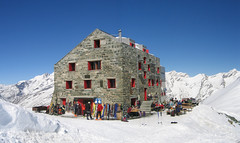


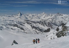
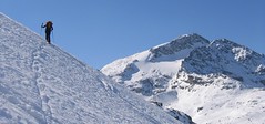
Excellent hut over Saas Fee skiresort (Wallis Alps), half an hour from the cable car. The starting point for five glacier tours - Fluchthorn, Strahlhorn, Rimpfischhorn, Allalinhorn and Alphubel.
Tours starting from hut
Ski tours around Hut Britannia Hütte
-
Fluchthorn 3802 m
Britannia Hütte Walliser Alpen / Alpes valaisannes Switzerland
- Length of ascent6 km
- ascent1000 m
- duration3-4,5 h
- Fitness difficulty ♦♦◊◊
- Technical difficulty ♦♦◊◊
Fluchthorn (Britannia Hütte, Wallis) is an optimal acclimatization tour for 4000 above Saas Fee and can be managed at the same time as the Strahlhorn.

-
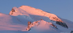
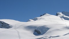
Strahlhorn 4190 m
Britannia Hütte Walliser Alpen / Alpes valaisannes Switzerland
- Length of ascent9,4 km
- ascent1250 m
- duration6-8 h
- Fitness difficulty ♦♦♦◊
- Technical difficulty ♦♦◊◊
Strahlhorn (Britannia Hütte, Walliser Alpen) is a classic glacier ski tour from Britannia Hütte. From the Adlerpass saddle, you usually go skiing to the top. To get off Saas Fee, take the Metro to the "window" at 3460 m to the Hohlaub Gletscher and start the ascent after a short ride.
-
Allalinhorn 4027 m
Britannia Hütte Walliser Alpen / Alpes valaisannes Switzerland
- Length of ascent3 km
- ascent580 m
- duration3-4 h
- Fitness difficulty ♦♦◊◊
- Technical difficulty ♦♦◊◊
ALLALINHORN (Britannia Hütte, Walliser Alpen) is one of the lightest 4000 in the Alps. By Metro in Mittelallalin and only 500 meters to the peak. In the case of excellent conditions the downhill slopes from the top west cross to the Feejoch.
-

Rimpfischhorn 4198 m
Britannia Hütte Walliser Alpen / Alpes valaisannes Switzerland
- Length of ascent12 km
- ascent1260 m
- duration7-10 h
- Fitness difficulty ♦♦♦◊
- Technical difficulty ♦♦♦♦
Rimpfischhorn is the most demanding ski tour of Saas Fee - Britannia Hütte (Walliser Alpen). Dangerous big cracks and at the finish climbing terrain.
-

Alphubel 4206 m
Britannia Hütte Walliser Alpen / Alpes valaisannes Switzerland
- Length of ascent10 km
- ascent1450 m
- duration7-10 h
- Fitness difficulty ♦♦♦◊
- Technical difficulty ♦♦♦◊
ALPHUBEL (Britannia Hütte, Walliser Alpen) is seemingly lighter 4000vka, but over are dangerous glacial cracks. Ski alpinists can also go from the Saas Fee ski area, most not far from the cable car station Langfluh .
- Country
- Switzerland
- Montains
- Walliser Alpen / Alpes valaisannes
- Open (winter)
- march-may
- Beds
- 134
- Winterraum
- open, 12 beds
- Shortening of access (cableway, lift, taxi, snowcat...)
- by cableway from Saas Fee to Felskinn (Allalinexpres / Felskin)
- Card Pay
- EC cards acceptable
- Shower
- no
- Wifi
- no
- UTM / CH1903 x ("longitude" E/W)
- 638420 (CH1903)
- UTM / CH1903 y ("latitude" N/S)
- 101070 (CH1903)
- GPX access to hut (waipoints, track)
- BritanniaHuette Access SKITOURguru.gpx
- GPX all tours from the hut
- BritanniaHut CH WALLIS all_SKITOURguru.gpx
- Map
- Mischabel 284 S, Swisstopo 1:50000 Saas 1329, Swisstopo 1:25000 Monte Moro 1349, Swisstopo 1:25000 Randa 1328, Swisstopo 1:25000 Zermatt 1348, Swisstopo 1:25000
- Guides
- Walliser Alpen Ost (SAC, deutsch) Die klassischen Skitouren (SAC deutsch) Les classiques de randonnée à ski (CAS, francais) Walliser Alpen
- Phone (hut)
- +41 (0)27 957 22 88
- Phone (valley)
- 0041 (0)79 396 94 03
- Cell phone
- -
- Mobile Signal
- yes, but outside the hut
- Web
- -
- cabane.britannia@saas-fee.ch
- Owner of hut
- CAS Genevoise
- Britannia Hütte
- Start Point
- Saas Fee - Felskinn (cableway upper station)
- UTM / CH1903 x ("longitude" E/W)
- 636937
- UTM / CH1903 y ("latitude" N/S)
- 102036
- Altitude
- 2989 m
- Ascent (height difference)
- 1080 m
- Time of Access
- 0,5 h
- Shortening lift
- by cableway from Saas Fee to Felskinn (Allalinexpres / Felskin)
- Avalanche danger
- SLF - Oberes Saastal (Gefahrenkarte Regional)
- Weather
- SRF Meteo Meteoschweiz snow-forecast.com Meteoblue - Saas Fee yr.no - Saas Fee yr.no - Saas Fee
- Snow report
- snow-forecast.com bergfex.ch onthesnow.com snow.myswitzerland.com/ skiresort.info
- Webcams
- Mittelallalin Langflue Saas Fee
- Region
- Saas Fee Wallis/Valais
- Public traffic
- vlaky - SBB autobusy - Postbus
- Skiresort nearby
- Saas Fee
- Other links
- Schweiz Tourism
hut Britannia Hütte - Reviews
There are no reviews in this section yet. Click the Add Review button to add first review.
Best ski tours in mountains Walliser Alpen / Alpes valaisannes, Switzerland
-

Pigne d´Arolla 3790 m
Cabane des Dix Walliser Alpen / Alpes valaisannes Switzerland
- Length of ascent6 km
- ascent1000 m
- duration5-7,5 h
- Fitness difficulty ♦♦◊◊
- Technical difficulty ♦♦♦◊
Pigne d´Arolla is a very popular and easily accessible viewpoint. The ski tour to the summit leads from the three mountain huts - Cabane Dix, Cabane Vignettes and Cabane Chanrion. The route from Dix goes around the glacial seracs to the saddle Col de la Serpentine and the summit can be reached on skis. A worthwhile summit on the Haute Routes to Zermatt.
-

Tour du Ciel - day 2 3404 m
Schönbielhütte Walliser Alpen / Alpes valaisannes Switzerland
- Length of ascent5 km
- ascent1190 m
- duration5-7 h
- Fitness difficulty ♦♦♦◊
- Technical difficulty ♦♦♦◊
Tour du Ciel (known as the reverse direction of the Haute Route Impériale) begins with the first real stage from the Schönbiel Hut, featuring a descent along the edge of the moraine. This is followed by a long, steep climb over glacier seracs, ideally tackled in the early morning. The subsequent ascent over the Hohlwäng Glacier to the Col Durand (3404 m) is then straightforward. An alternative is to turn right before the pass and climb Mont Durand. From the pass, descend over the Glacier Durand, followed by a short climb to the Cabane Mountet.
-

La Luette 3547 m
Cabane des Dix Walliser Alpen / Alpes valaisannes Switzerland
- Length of ascent3 km
- ascent710 m
- duration1,5-3 h
- Fitness difficulty ♦♦◊◊
- Technical difficulty ♦♦◊◊
La Luette je vděčná túra z chaty Cabane Dix. Po mírném svahu na ledovec Glacier de la Luette a v závěru po hřebenu na vrchol. Pouhých 500 výškových metrů od chaty může být lákadlem pro odpolední túru poté, když dorazíte brzo na chatu Dix.
Best ski tours in Switzerland by skitour.guru
-

Gross Wannenhorn 3905 m
Finsteraarhornhütte Berner Alpen / Alpes bernoises Switzerland
- Length of ascent6,5 km
- ascent1310 m
- duration5,5-7,5 h
- Fitness difficulty ♦♦♦◊
- Technical difficulty ♦♦♦◊
The top of the Gross Wannenhorn is a first-class lookout tower on the largest alpine glacier, the Aletsch glacier and the many 4,000-meter peaks in the Bernese Alps. After a short descent from the Finsteraarhorn Hut over the glacier Fieschergletscher at the foot of the Wannenhorn. During the ascent along a wide slope, watch out for numerous and large crevasses. Finally, the ascent line turns westwards upwards. When driving downhill, copy the exit route and pay attention to crevasses again.
-
Piz Surlej - Piz San Gian 3187 m
St. Moritz Bernina Alps Switzerland
- Length of ascent4 km
- ascent990 m
- duration4-6 h
- Fitness difficulty ♦♦◊◊
- Technical difficulty ♦♦♦◊
Piz Surlej and Piz San Gian is an interesting ski tour over two neighboring peaks. In the morning you take the cable car to Piz Corvatsch and enjoy the wonderful view of the Albula Alps as well as the lakes Sils and Silvaplana. Follow the ski slope to the Margun Vegl cable car station or to the upper station (2643 m). A logical line to Piz Surlej and further along the ridge to Piz San Gian. And then a spectacular descent to St. Moritz. Warning, some slopes of this ski tour have avalanche potential, especially the descent from the San Gian summit to St. Moritz. This tour is for skiers with good riding technique.
-

Tödi 3614 m
Fridolinshütte Glarus Alps Switzerland
- Length of ascent6 km
- ascent1495 m
- duration7-10 h
- Fitness difficulty ♦♦♦◊
- Technical difficulty ♦♦♦♦
In the Middle Ages, Tödi was considered the highest mountain in the world. Today it is an attractive destination for ski mountaineers, but it is not easy to hit good weather. The ascent is made difficult by a glacier littered with fractures and cracks. Starts from the Fridolins hut over the moraine and descends briefly to the Bifertenfirn glacier. The hardest part is to overcome the first two drops, then the climb up is relatively easy. Depending on the conditions on skis or with crampons to the summit. Provides information about the current conditions on the glacier in the Fridolinshütte.