
 Česky
Česky Deutsch


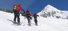
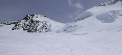
Cabane Chanrion offers a variety of ski tours and is also an important stop on the famous Haute Route Chamonix - Zermatt. You can reach it from Valsorey via the Plateau Couloir. The continuation to the Cabane Vignettes either leads over the Otemna glacier or over a more interesting route through the Les Portons. The most difficult peak in the region is La Ruinette. The FXB Panossiere can be reached via Tournelon Blanc. The Chalet Dix and the Arolla Valley can be reached via Cabane Dix with a fork to Mont Blanc Cheilon. The access from the Mauvoisin Dam is at risk from avalanches and is not recommended. Contact the hut for detailed information.
Tours starting from hut
Ski tours around Hut Cabane Chanrion
-

Pigne Arolla, Day 5 H.R. Chamonix-Zermatt 3790 m
Cabane Chanrion Walliser Alpen / Alpes valaisannes Switzerland
- Length of ascent9 km
- ascent1690 m
- duration7,5-9 h
- Fitness difficulty ♦♦♦◊
- Technical difficulty ♦♦♦◊
The Haute Route from Chamonix to Zermatt between the Chanrion and Vignetts huts offers two options. The clear number one is the line between the ridges above the Col Portons saddle. The only complication may be a few climb steps in the saddle, but it's all about a fantastic ski tour. A great highlight of this skitour is a bonus in the form of the Pigne Arolla summit. Then only the descent to Cabane Vignettes remains.

-
La Ruinette 3875 m
Cabane Chanrion Walliser Alpen / Alpes valaisannes Switzerland
- Length of ascent8 km
- ascent1490 m
- duration7-9,5 h
- Fitness difficulty ♦♦♦♦
- Technical difficulty ♦♦♦♦
Velkolepá a náročná túra na vrchol v monumentální horské krajině mezi ledovci. Z chaty Chanrion po trase do sedla Portons. Včas odboč doleva na ledovec Brenay. Klíčem k úspěchu je trefit kanál, kterým se vystoupá na svah Ruinette a poměrně snadno se pokračuje do sedla pod vrcholovou pyramidu. Tady je skidepot a dále v mačkách a s cepínem. Sjezd po trase výstupu.
- Country
- Switzerland
- Montains
- Walliser Alpen / Alpes valaisannes
- Open (winter)
- mid March - mid May
- Beds
- 73
- Winterraum
- yes, 15 beds
- Shortening of access (cableway, lift, taxi, snowcat...)
- no
- Luggage transport
- no
- Card Pay
- no
- Shower
- no
- Wifi
- no
- UTM / CH1903 x ("longitude" E/W)
- 595520
- UTM / CH1903 y ("latitude" N/S)
- 87510
- GPX access to hut (waipoints, track)
- Chanrion-Hut_access_Mauvoisin.gpx
- GPX access to hut (track only)
- Chanrion-Hut_all_access_TRK.gpx
- Map
- Arolla 283 S, Swisstopo 1:50000 Chanrion 1346, Swisstopo 1:25000 Matterhorn 1347, Swisstopo 1:25000
- Guides
- Ski de randonnée Bas-Valais Die klassischen Skitouren (SAC, deutsch) Les classiques de randonnée à ski (SAC, francais) Walliser Alpen (Rother, deutsch)
- Phone (hut)
- 0041(0)27 771 33 22
- Phone (valley)
- 0041(0) 79 219 29 23
- Cell phone
- -
- Mobile Signal
- no
- Web
- chanrion.ch
- info@chanrion.ch
- Owner of hut
- CAS Section genevoise
- Cabane Chanrion
- Reservation
- phone, online former
- Online reservation
- chanrion.ch
- Start Point
- Mauvoisin
- UTM / CH1903 x ("longitude" E/W)
- 592471
- UTM / CH1903 y ("latitude" N/S)
- 94537
- Altitude
- 1855 m
- Ascent (height difference)
- 1260 m
- Time of Access
- 4,5 - 6 h
- Shortening lift
- no
- Avalanche danger
- www.slf.ch
- Weather
- SRF Meteo Meteoschweiz snow-forecast.com Pointe d'Otemma, mountain-forecast.com Mont Avril, mountain-forecast.com La Ruinette, mountain-forecast.com Lac Mauvoisin - meteoblue.com Mont Oulié, mountain-forecast.com Grand Teve, Meteoblue.com Lac Mauvoisin - yr.no
- Snow report
- snow-forecast.com - Verbier bergfex.ch - Verbier onthesnow.com skiresort.info snow.myswitzerland.com/
- Webcams
- Mont Fort 3300 m (Verbier) Lourtier - Val Bagnes
- Region
- Vallée de Bagnes Wallis.ch Lac Mauvoisin - verbier.ch
- Public traffic
- train SBB Bus - Postauto.ch
- Skiresort nearby
- Verbier
- Other links
- Swiss Tourism
hut Cabane Chanrion - Reviews
There are no reviews in this section yet. Click the Add Review button to add first review.
Best ski tours in mountains Walliser Alpen / Alpes valaisannes, Switzerland
-

Bishorn 4153 m
Cabane Tracuit Walliser Alpen / Alpes valaisannes Switzerland
- Length of ascent4,5 km
- ascent950 m
- duration5-6,5 h
- Fitness difficulty ♦♦♦◊
- Technical difficulty ♦♦◊◊
Bishorn seems to be a relatively light 4000, but looks are deceptive. If you include the approach to Cabane Tracuit from Zinal in the ascent, it is quite a long ski tour. From the hut the ascent line leads slightly up the glacier Turtmanngletscher. Directly below the peak on the plateau you have to swap skis for crampons and comfortably climb to the panoramic summit - one of the best in all of Valais. Driving down the northern slope is usually a fantastic enjoyment, the risk of glacier cracks is minimal.
-

Col Valpelline, Day 6 H.R. Chamonix-Zermatt 3551 m
Cabane des Vignettes Walliser Alpen / Alpes valaisannes Switzerland
- Length of ascent9 km
- ascent1485 m
- duration8-10 h
- Fitness difficulty ♦♦♦◊
- Technical difficulty ♦♦♦◊
The last stage of the Haute Route Chamonix - Zermatt is an ode to skiing. After an easy ascent to three saddles - Col de Eveque, Col du Mont Brulé and Col Valpelline. Every ski mountaineer will be amazed by the panorama of the impressive 4000m peaks - Dent Blanche, Matterhorn and Dent d´Hérens. This is followed by a 10 km descent to Zermatt.
-

Tour du Ciel - day 5 3030 m
Turtmannhütte / Cabane Tourtemagne Walliser Alpen / Alpes valaisannes Switzerland
- Length of ascent5,5 km
- ascent1110 m
- duration5-7 h
- Fitness difficulty ♦♦◊◊
- Technical difficulty ♦♦◊◊
A relatively easy ascent, though steep in places, from Lake Turtmannsee, which is reached by descending from the Turtmannhütte. From the summit ridge, there's a long descent to the Hotel Weisshorn, followed by forest trails leading down to the village of St. Luc - Chandolin in the Val d'Anniviers.
Best ski tours in Switzerland by skitour.guru
-

Piz Buin SE (Tuoihütte) 3312 m
Tuoi Chamonna / Tuoihütte Silvretta Switzerland
- Length of ascent5,5 km
- ascent1170 m
- duration5,5-7 h
- Fitness difficulty ♦♦♦◊
- Technical difficulty ♦♦♦◊
Piz Buin ze švýcarské strany je zajímavější túra než ze strany rakouské. výstup v závěrečné části je stejný. Pod stěnu vede trasa přes sedla Plan Mezdi a Fuorcla dal Cunfin. Za stabilní sněhové pokrývky je alternativou sjezd žlabem Buinlücke.
-

Diechterhorn (day 3, h.r. Swiss Glacier) 3389 m
Trifthütte Urner Alps Switzerland
- Length of ascent12 km
- ascent2100 m
- duration10-12 h
- Fitness difficulty ♦♦♦♦
- Technical difficulty ♦♦♦♦
Hiking on top of fantastic lookout tower. Glacier skitour. At the end, you will reach the summit from the north, to the top of the climbing terrain. Next continue to the Diechterlimi saddle and from there a fantastic downhill run to Gelmerhütte and then to the Gelmersee dam. If the lake is not frozen, the route along the northern bank can be very challenging, depending on the snow conditions. After crossing the dam, is coming downhill, often very complicated, traversing western slope to the Grimselpass road. After that, a bit on the parking lot under the Räterichsboden dam and at first a steep traverse to Bächlihütte - a hut on the top.
-
Grosses Grünhorn 4044 m
Konkordiahütte Berner Alpen / Alpes bernoises Switzerland
- Length of ascent7 km
- ascent1380 m
- duration6,5-8,5 h
- Fitness difficulty ♦♦♦◊
- Technical difficulty ♦♦♦◊
Gross Grünhorn is the only 4000 meter in the Konkordiahütte area. The ascent leads from Konkordiaplatz along the edge of the Ewigschneefeld glacier and then along the northwestern slopes of the Grünhorn ridge. Beware of glacier cracks around the saddle between Grünegghorn and Gross Grünhorn. Not far from the saddle is a ski depot, from which you can go up with crampons and ice ax. The descent along the ascent route is safer than the descent variant through Grüneggfirn (glacier cracks).