
 Česky
Česky Deutsch


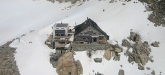


Cabane Trient is not far from the border between Switzerland and France. The Hut is a stop on the famous Haute Route Chamonix - Zermatt. It is easiest to reach the hut from the Grands Montets and Lognan cable car stations via the Col Chardonnet and Fenétre de Saleinaz saddles. Another variant of the approach leads from Le Tour. The Haute Route to Lac Champex leads through the Val d´Arpette or through the Glacier d´Orny.
Tours starting from hut
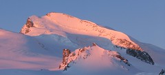
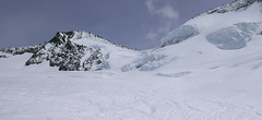
Ski tours around Hut Cabane Trient
-

Col Grande Lui - H.R. Grande Lui, Day 2 3416 m
Cabane Trient Walliser Alpen / Alpes valaisannes Switzerland
- Length of ascent6 km
- ascent925 m
- duration6-8 h
- Fitness difficulty ♦♦♦◊
- Technical difficulty ♦♦♦◊
Variant of the Haute Route Gran Lui from Chamonix to Zermatt: From the Cabane du Trient hut over the Col de Plines pass and descent onto the Glacier de Saleinaz. This is followed by an ascent to the Col de la Grande Lui pass. From the pass, a long descent leads to the mountain village of La Fouly.

-

Val Arpette (Day2, H.R. Chamonix-Zermatt) 2793 m
Cabane Trient Walliser Alpen / Alpes valaisannes Switzerland
- Length of ascent0,2 km
- ascent160 m
- duration3-5 h
- Fitness difficulty ♦♦◊◊
- Technical difficulty ♦♦◊◊
One of the two variants of the 2nd day stage of the classic Haute Route Chamonix-Zermatt. From the hut Cabane Trient, descend briefly northwards, then a short climb to the saddle Col Escandies (2793 m). Complicated terrain from the saddle down, often with crampons and skis on a backpack. Then a long descent along the north-east slope through the Val d´Árpette to Champex. From there by bus to Orsiéres, it is good to take the bus at 12:58, in Orsieres change to the connection to Bourg St-Pierre (2:00 p.m.).
- Country
- Switzerland
- Montains
- Walliser Alpen / Alpes valaisannes
- Open (winter)
- mid March - mid May
- Beds
- 128
- Winterraum
- open, 34 beds
- Shortening of access (cableway, lift, taxi, snowcat...)
- yes, from Le Tour to Les Autannes
- Luggage transport
- no
- Card Pay
- no
- Shower
- no
- Wifi
- no
- UTM / CH1903 x ("longitude" E/W)
- 569402
- UTM / CH1903 y ("latitude" N/S)
- 94304
- GPX access to hut (waipoints, track)
- Trient-Hut_all_acces_skitour.gpx
- GPX access to hut (track only)
- Trient-Hut_all_access_TRK.gpx
- Map
- Martigny 282 S, Swisstopo 1:50000 Barberine 1324, Swisstopo 1:25000 Col de Balme 1344, Swisstopo 1:25000 Orsières 1345, Swisstopo 1:25000 Chamonix 3630, IGN 1:25000
- Guides
- Ski de randonnée Bas-Valais Die klassischen Skitouren (SAC, deutsch) Les classiques de randonnée à ski (SAC, francais) Walliser Alpen (Rother, deutsch) Haute Route (Rother, deutsch) Haute Route Chamonix-Zermatt (JM editions, french)
- find current conditions and experiences on the spot
- gipfelbuch.ch
- Phone (hut)
- +41 27 783 14 38
- Phone (valley)
- -
- Cell phone
- -
- Mobile Signal
- no
- Web
- cas-diablerets.ch
- trient@cas-diablerets.ch
- Owner of hut
- CAS Diablerets
- Cabane Trient
- Reservation
- phone only
- Start Point
- Le Tour
- UTM / CH1903 x ("longitude" E/W)
- 32T 341012
- UTM / CH1903 y ("latitude" N/S)
- 5096506
- Altitude
- 1453 m
- Ascent (height difference)
- 1720 m
- Time of Access
- 6-8 h
- Shortening lift
- yes, from Le Tour to Les Autannes
- Start Point
- Champex, via Arpette
- UTM / CH1903 x ("longitude" E/W)
- 575350
- UTM / CH1903 y ("latitude" N/S)
- 97363
- Altitude
- 1467 m
- Ascent (height difference)
- 1865 m
- Time of Access
- 6-8 h
- Shortening lift
- no
- Avalanche danger
- www.slf.ch
- Weather
- Cabane Trient, meteoblue.com Petite Pointe d´Orny 3187m / mountain-forecast.com Aig. du Pissoir 3440m / mountain-forecast.com Pointe des Grandes 3101m / mountain-forecast.com Tete de Balme 2321m / mountain-forecast.com La Breya 2194m / mountain-forecast.com Le Tour, meteoblue Grands Montets, meteoblue.com Lac Champex, meteoblue Meteoschweiz Vallorcine-Le Tour
- Snow report
- Champex-Lac, bergfex.ch Verbier,skiresort.info Le Tour, snow-forecast.com Chamonix, onthesnow.com
- Webcams
- Lognan - Grands Montets Les Autannes Trient Glacier Chamonix, all webcams Champex - Val Arpette
- Region
- Trient Commune Chamonix Val de Bagnes Wallis.ch Chamonix Valley accommodation
- Public traffic
- train SBB Bus - Postauto.ch
- Skiresort nearby
- Le Tour - Vallorcine (FRA) Argentiére - Grands Montets (FRA) Champex (CH) Chamonix Mont-Blanc
- Other links
- Swiss Tourism France Tourism
hut Cabane Trient - Reviews
There are no reviews in this section yet. Click the Add Review button to add first review.
Best ski tours in mountains Walliser Alpen / Alpes valaisannes, Switzerland
-
Strahlhorn 4190 m
Britannia Hütte Walliser Alpen / Alpes valaisannes Switzerland
- Length of ascent9,4 km
- ascent1250 m
- duration6-8 h
- Fitness difficulty ♦♦♦◊
- Technical difficulty ♦♦◊◊
Strahlhorn (Britannia Hütte, Walliser Alpen) is a classic glacier ski tour from Britannia Hütte. From the Adlerpass saddle, you usually go skiing to the top. To get off Saas Fee, take the Metro to the "window" at 3460 m to the Hohlaub Gletscher and start the ascent after a short ride.
-

Tour du Ciel - day 4 4153 m
Cabane Tracuit Walliser Alpen / Alpes valaisannes Switzerland
- Length of ascent6 km
- ascent1150 m
- duration5,5-7,5 h
- Fitness difficulty ♦♦♦◊
- Technical difficulty ♦♦♦◊
The stage begins at the Cabane Tracuit with an ascent of the 4,000-meter peak Bishorn, which is considered relatively easy. After skiing back down to the Tracuit hut, the route continues with a descent over the Turtmanngletscher glacier. A subsequent climb over the Brunegggletscher glacier leads into a rocky corridor, which marks the beginning of the descent to the Turtmannhütte.
-

Breithorn - Zermatt 4164 m
Monte Rosa Hütte Walliser Alpen / Alpes valaisannes Switzerland
- Length of ascent3 km
- ascent440 m
- duration3-4 h
- Fitness difficulty ♦♦♦◊
- Technical difficulty ♦♦♦◊
Breithorn can be rated as the lightest 4000 in the Alps. In any case, thanks to the support of the Klein Matterhorn cable car, which transports ski mountaineers up to 3880 m. From the cable car station (beautiful viewpoint) to the glacier plain below the summit, which can be often reached on skis. In good conditions, it is worthwhile to continue to the Schwarztor saddle and drive descent back to Zermatt. The second variant of the freeride is the descent from the Unterer Theodulgletscher. This descent is simply great up to Seehöre 2400.
Best ski tours in Switzerland by skitour.guru
-

Monte Rosso 3088 m
Fornohütte - Capanna del Forno Bernina Alps Switzerland
- Length of ascent4 km
- ascent840 m
- duration4-5,5 h
- Fitness difficulty ♦♦◊◊
- Technical difficulty ♦♦♦◊
Skvělým skialpovým vrcholem uprostřed oblasti je Monte Rosso. Výhodou okruhu je maximalistický krajinářský zážitek. Po výstupu do dvou sedel se otevřou vždy nové výhledy. Od chaty míříme nejprve do sedla Sella del Forno. Koukáme na Berninu a dolů na skiresort Valmalenco. Krásným kotlem po krátkém sjezdu traverujeme a míříme nahoru do druhého sedla – Passo di Val Bona. Po strmějším svahu do místa na skalním hřebenu, kde je skidepot. Odtud v mačkách na vrchol. Na lyžích parádní sjezd jihozápadním svahem na ledovec Forno a zpět nahoru k chatě.
-

Gletscher Ducan 3019 m
Davos Albula Alps Switzerland
- Length of ascent6,5 km
- ascent1360 m
- duration5,5-7 h
- Fitness difficulty ♦♦◊◊
- Technical difficulty ♦♦♦◊
The Ducan Gletscher is a summit with a wonderful view of the Piz Kesch and especially the Piz Ela. The ski tour starts in Monstein, where the highest brewery in Europe is located. The Fanezfurgga saddle leads to valley with a striking mountain. The end of the climb up is usually with ice axe and crampons. The descent through the Ducantal valley is oriented to the north and leads skiers into the Sertigtal valley. The route can also be done in the opposite direction. It is advisable to undertake the tour with the support of public transport.
-
Grosses Grünhorn 4044 m
Konkordiahütte Berner Alpen / Alpes bernoises Switzerland
- Length of ascent7 km
- ascent1380 m
- duration6,5-8,5 h
- Fitness difficulty ♦♦♦◊
- Technical difficulty ♦♦♦◊
Gross Grünhorn is the only 4000 meter in the Konkordiahütte area. The ascent leads from Konkordiaplatz along the edge of the Ewigschneefeld glacier and then along the northwestern slopes of the Grünhorn ridge. Beware of glacier cracks around the saddle between Grünegghorn and Gross Grünhorn. Not far from the saddle is a ski depot, from which you can go up with crampons and ice ax. The descent along the ascent route is safer than the descent variant through Grüneggfirn (glacier cracks).