
 Česky
Česky Deutsch


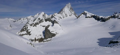
The mountain hut Cabane Bertol is perched on a rock above the Glacier du Mont Miné and offers wide-ranging views. The ascent to the hut is via ladders. Cabane Bertol is accessible from both Arolla and Zermatt. It is also a popular stop on the Haute Route from Chamonix to Zermatt. From Bertol, relatively easy glacier tours lead to the summits of Tête Blanche and Tête de Valpelline.
Tours starting from hut
Ski tours around Hut Cabane Bertol
- Country
- Switzerland
- Montains
- Walliser Alpen / Alpes valaisannes
- Open (winter)
- April - August
- Beds
- 80
- Winterraum
- yes, 16 beds
- Shortening of access (cableway, lift, taxi, snowcat...)
- no
- Luggage transport
- no
- Card Pay
- yes
- Shower
- no
- Wifi
- no
- UTM / CH1903 x ("longitude" E/W)
- 606900
- UTM / CH1903 y ("latitude" N/S)
- 94961
- GPX all tours from the hut
- BertolCab_ALL_skitours.gpx
- Map
- Arolla 283 S, Swisstopo 1:50000 Matterhorn 1347, Swisstopo 1:25000
- Guides
- Ski de randonnée Bas-Valais Die klassischen Skitouren (SAC, deutsch) Les classiques de randonnée à ski (SAC, francais) Walliser Alpen (Rother, deutsch)
- Phone (hut)
- +41 79 626 65 79
- Phone (valley)
- -
- Cell phone
- -
- Mobile Signal
- yes
- Web
- bertol.ch
- bertol@cas-neuchatel.ch
- Owner of hut
- CAS Neuchateloise
- Cabane Bertol
- Reservation
- phone
- Start Point
- Arolla - parking
- UTM / CH1903 x ("longitude" E/W)
- 603324
- UTM / CH1903 y ("latitude" N/S)
- 96838
- Altitude
- 2008 m
- Ascent (height difference)
- 1340 m
- Time of Access
- 4,5-6 h
- Shortening lift
- no
- Avalanche danger
- www.slf.ch
- Weather
- SRF Meteo Meteoschweiz Cabane Vignettes. meteoblue.com Mont Collon, mountain-forecast.com Pigne Arolla, mountain-forecast.com L´Eveque, mountain-forecast.com Arolla, yr.no Arolla, snow-forecast.com
- Snow report
- Arolla, snow-forecast.com Arolla, bergfex.ch Arolla, onthesnow.com skiresort.info snow.myswitzerland.com/
- Webcams
- Evolene Arolla
- Region
- Val d´Hérens Wallis.ch
- Public traffic
- train SBB bus - Postauto.ch
- Skiresort nearby
- Arolla Verbier
- Other links
- Swiss Tourism
hut Cabane Bertol - Reviews
There are no reviews in this section yet. Click the Add Review button to add first review.
Best ski tours in mountains Walliser Alpen / Alpes valaisannes, Switzerland
-

Tour du Ciel - day 2 3404 m
Schönbielhütte Walliser Alpen / Alpes valaisannes Switzerland
- Length of ascent5 km
- ascent1190 m
- duration5-7 h
- Fitness difficulty ♦♦♦◊
- Technical difficulty ♦♦♦◊
Tour du Ciel (known as the reverse direction of the Haute Route Impériale) begins with the first real stage from the Schönbiel Hut, featuring a descent along the edge of the moraine. This is followed by a long, steep climb over glacier seracs, ideally tackled in the early morning. The subsequent ascent over the Hohlwäng Glacier to the Col Durand (3404 m) is then straightforward. An alternative is to turn right before the pass and climb Mont Durand. From the pass, descend over the Glacier Durand, followed by a short climb to the Cabane Mountet.

-

Bishorn 4153 m
Cabane Tracuit Walliser Alpen / Alpes valaisannes Switzerland
- Length of ascent4,5 km
- ascent950 m
- duration5-6,5 h
- Fitness difficulty ♦♦♦◊
- Technical difficulty ♦♦◊◊
Bishorn seems to be a relatively light 4000, but looks are deceptive. If you include the approach to Cabane Tracuit from Zinal in the ascent, it is quite a long ski tour. From the hut the ascent line leads slightly up the glacier Turtmanngletscher. Directly below the peak on the plateau you have to swap skis for crampons and comfortably climb to the panoramic summit - one of the best in all of Valais. Driving down the northern slope is usually a fantastic enjoyment, the risk of glacier cracks is minimal.
-

Fenetre Ferret - H.R. Grande Lui, Day 3 2698 m
La Fouly Walliser Alpen / Alpes valaisannes Switzerland
- Length of ascent11 km
- ascent1330 m
- duration5-7 h
- Fitness difficulty ♦♦♦◊
- Technical difficulty ♦♦◊◊
The Haute Route Grande Lui variant from Chamonix to Zermatt, also known as the "Haute Route Pure", leads from La Fouly to the Grand Saint Bernard Pass. Overnight accommodation is provided in the hospice of the same name, under conditions similar to those in a mountain hut. The traverse of the slope below the Ferret lakes is particularly prone to avalanches.
Best ski tours in Switzerland by skitour.guru
-

Clariden E, from Claridenhütte 3267 m
Claridenhütte Glarus Alps Switzerland
- Length of ascent6 km
- ascent1025 m
- duration4,5-6 h
- Fitness difficulty ♦♦◊◊
- Technical difficulty ♦♦◊◊
After Tödi, Clariden is the second most popular ski tour in the Glarus Alps. The ascent leads along the gentle Claridenfirn glacier from Claridenhütte to the foot of Clariden and then through a wide northeast slope to the top pyramid. Beautiful views of the entire Glarus Alps and the neighboring Uri Alps. Descent copies the ascent track. A popular alternative is to continue crossing the Planura hut after descending the steep slope turn right to Claridenpass.
-
Vorderes Galmihorn 3507 m
Oberaarjochhütte Berner Alpen / Alpes bernoises Switzerland
- Length of ascent2,5 km
- ascent760 m
- duration4,5-6,5 h
- Fitness difficulty ♦♦◊◊
- Technical difficulty ♦♦♦◊
Vorderes Galmihorn je skvělý skialpový vrchol na závěr akce v centru Bernských Alp. Po výstupu na vrchol z chaty Oberaletschhütte přináší skvělou možnost sjezdu do údolí Goms, což je logisticky výhodné v případě startu lanovkou z Fiesch. Výstup vede po mírném ledovci Galmigletscher a dále po přehledném svahu posetém trhlinami. Při sjezdu dávejte pozor na trhlinu pod sedlem Bächlilicke. Na jaře vás v závěru túry nemine pochod do údolí s lyžemi na batohu. Nabízí se sjezd do Reckingenu nebo Münsteru.
-

Pizzi dei Rossi 3026 m
Fornohütte - Capanna del Forno Bernina Alps Switzerland
- Length of ascent3 km
- ascent665 m
- duration4,5-6 h
- Fitness difficulty ♦♦◊◊
- Technical difficulty ♦♦♦♦
Skialpová Pizzi dei Rossi je ideální volbou pro poslední den na chatě. Návrat na parkoviště pod Malojapassem má úplně jinou úroveň, než přesun údolím. Výstup z chaty vede často traverzy zápaního svahu, na jaře jsou haršajsny nutností. Náročný je až výstup prudkým svahem do sedla, většinou bude nutné nasadit mačky a lyže dát batoh. Ze sedla nalehko a bez lyží na vrchol. Sjezd severním kuloárem je zprvu velmi prudký a bmusí se projet zúžením mezi skalami. Dál po pláních je už luxusní svah a když je dobrý sníh, je to fantastický sjezd. Ten pokračuje i údolím Val Muretto až na planinu Canis. Pár krátkých protisvahů na kraj soutěsky a pak už zase jen dolů k mostu přes horskou bystřinu a po rovině na parkoviště.