
 Česky
Česky Deutsch


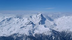
Cabane du Mountet is in the grip of wild glacier mountains, especially Dent Blanche. Access to the mountain hut is from Zinal through the valley Zinaltal and over the Glacier de Zinal. Mountet Hut is located on the Haute Route Imperial, french named is Tour du Ciel. Starting point for ski tours on L'Epaule, Blanc de Momong and Mont Durand / Arbenhorn. The location of the Mountethütte promises beautiful mountain views while you rest after the ski mountaineering.
Tours starting from hut
Ski tours around Hut Cabane du Mountet
-

Blanc de Moming - Dôme Circuit 3649 m
Cabane du Mountet Walliser Alpen / Alpes valaisannes Switzerland
- Length of ascent10 km
- ascent2035 m
- duration9-11 h
- Fitness difficulty ♦♦♦♦
- Technical difficulty ♦♦♦♦
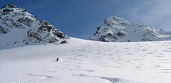
Blanc de Moming - Dôme is a beautiful but also very demanding complex ski tour. First ascent from Cabane Mountet to La Forcle saddle and then not very easy descent and then ascent along the Glacier du Besso. At the end of the glacier there is an uncomfortable border between snow and rock. Climb a rocky slope. First along a flat ridge, which is increasingly exposed. It is recommended to belay in windy weather. At the beginning of the spectacular descent along the Glacier de Moming, pay attention to the gigantic cracks. The departure line (keep left) turns from the northern to the western slope. After reaching the valley there is an easy ascent along the Glacier de Zinal back to Cabane Mountet.

-

Tour du Ciel - day 3 3649 m
Cabane du Mountet Walliser Alpen / Alpes valaisannes Switzerland
- Length of ascent10,5 km
- ascent2420 m
- duration10-12 h
- Fitness difficulty ♦♦♦♦
- Technical difficulty ♦♦♦♦
A very long and demanding, royal stage of this Haute Route. In my opinion, the most impressive stage of all multi-day Alpine crossings. Due to the elevation gain and time required, it’s worth considering splitting the stage into two days with an overnight stay in Zinal. The long, exposed ridge to the summit requires rope protection depending on conditions. The descent is fantastically long, but caution is needed – there are large crevasses. This ski tour is only recommended in stable weather; in poor conditions, it’s advisable to bypass the Blanc de Moming via the Glacier de Zinal and ascend directly to the Cabane de Tracuit.
- Country
- Switzerland
- Montains
- Walliser Alpen / Alpes valaisannes
- Open (winter)
- end March - end May
- Beds
- 115
- Winterraum
- yes, 30 beds
- Shortening of access (cableway, lift, taxi, snowcat...)
- no
- Luggage transport
- no
- Card Pay
- no
- Shower
- no
- Wifi
- no
- UTM / CH1903 x ("longitude" E/W)
- 616621
- UTM / CH1903 y ("latitude" N/S)
- 100963
- GPX access to hut (waipoints, track)
- Mountet-Hut_access_Zinal.gpx
- GPX access to hut (track only)
- Mountet-Hut_access_Zinal_TRK.gpx
- Map
- Arolla 283 S, Swisstopo 1:50000 Evolene 1327, Swisstopo 1:25000
- Guides
- Ski de randonnée Bas-Valais Die klassischen Skitouren (SAC, deutsch) Les classiques de randonnée à ski (SAC, francais) Walliser Alpen (Rother, deutsch)
- Phone (hut)
- +41 27 475 14 31
- Phone (valley)
- -
- Cell phone
- -
- Mobile Signal
- no
- Web
- cas-diablerets.ch
- mountet@cas-diablerets.ch
- Owner of hut
- CAS Diablerets
- Cabane Grand Mountet CAS
- Reservation
- online former
- Online reservation
- alpsonline.org
- Start Point
- Zinal
- UTM / CH1903 x ("longitude" E/W)
- 614392
- UTM / CH1903 y ("latitude" N/S)
- 109620
- Altitude
- 1670 m
- Ascent (height difference)
- 1210 m
- Time of Access
- 5-6 h
- Shortening lift
- no
- Avalanche danger
- www.slf.ch
- Weather
- SRF Meteo Meteoschweiz Zinal, snow-forecast.com Zinal, meteoblue.com Blanc Moming 3663 / mountain-forecast.com L´Epaule 4017 / mountain-forecast.com Grand Cornier 3961m / mountain-forecast.com Mont Durand 3774, mountain-forecast.com Schweiz TV - animation Bergwetter / alpenverein.at
- Snow report
- Zinal, snow-forecast.com Zinal, bergfex.ch Zinal, onthesnow.com Zinal, skiresort.info snow.myswitzerland.com/
- Webcams
- Evoléne Zinal webcams
- Region
- Val d´Anniviers Wallis.ch
- Public traffic
- train SBB bus - Postauto.ch
- Skiresort nearby
- Grimentz-Zinal
- Other links
- Swiss Tourism
hut Cabane du Mountet - Reviews
There are no reviews in this section yet. Click the Add Review button to add first review.
Video of ski tour
Best ski tours in mountains Walliser Alpen / Alpes valaisannes, Switzerland
-

Alphubel 4206 m
Britannia Hütte Walliser Alpen / Alpes valaisannes Switzerland
- Length of ascent10 km
- ascent1450 m
- duration7-10 h
- Fitness difficulty ♦♦♦◊
- Technical difficulty ♦♦♦◊
ALPHUBEL (Britannia Hütte, Walliser Alpen) is seemingly lighter 4000vka, but over are dangerous glacial cracks. Ski alpinists can also go from the Saas Fee ski area, most not far from the cable car station Langfluh .
-

Pigne d´Arolla 3790 m
Cabane des Dix Walliser Alpen / Alpes valaisannes Switzerland
- Length of ascent6 km
- ascent1000 m
- duration5-7,5 h
- Fitness difficulty ♦♦◊◊
- Technical difficulty ♦♦♦◊
Pigne d´Arolla is a very popular and easily accessible viewpoint. The ski tour to the summit leads from the three mountain huts - Cabane Dix, Cabane Vignettes and Cabane Chanrion. The route from Dix goes around the glacial seracs to the saddle Col de la Serpentine and the summit can be reached on skis. A worthwhile summit on the Haute Routes to Zermatt.
-

Tour du Ciel - day 4 4153 m
Cabane Tracuit Walliser Alpen / Alpes valaisannes Switzerland
- Length of ascent6 km
- ascent1150 m
- duration5,5-7,5 h
- Fitness difficulty ♦♦♦◊
- Technical difficulty ♦♦♦◊
The stage begins at the Cabane Tracuit with an ascent of the 4,000-meter peak Bishorn, which is considered relatively easy. After skiing back down to the Tracuit hut, the route continues with a descent over the Turtmanngletscher glacier. A subsequent climb over the Brunegggletscher glacier leads into a rocky corridor, which marks the beginning of the descent to the Turtmannhütte.
Best ski tours in Switzerland by skitour.guru
-

Jungfrau 4158 m
Konkordiahütte Berner Alpen / Alpes bernoises Switzerland
- Length of ascent10 km
- ascent1510 m
- duration6,5-9 h
- Fitness difficulty ♦♦♦◊
- Technical difficulty ♦♦♦◊
Skialpová túra na Jungfrau z chaty Konkordia začíná velmi dlouhým nástupem po ledovci Jungfraufirn. Následuje prudký výstup na hřeben a dále do sedla Rottalsattel přes nepříjemnou thlinu. Skidepot a na mčkách a s cepínem po plochém hřebenu na vrchol. Alternativní sjezd přes sedlo Louwitor na ledovec Aletschfirn a po něm na chatu Konkordia. Možné je po dosažení vrcholu pokračovat na nádraží Jungfraujoch nebo nocovat na Mönchsjochhütte.
-
Piz Platta 3392 m
Mulegns - Posthotel Löwen Platta Group / Oberhalbstein Switzerland
- Length of ascent11 km
- ascent1980 m
- duration8-11 h
- Fitness difficulty ♦♦♦♦
- Technical difficulty ♦♦♦◊
Impressive very long ski tour on the more pronounced Piz Platta summit in the Plattagruppe-Oberhalbstein mountain group. Aproach from the village of Mulengs - road from Tiefencastel to Julierpass. First a few kilometers through the forest, then left at the foot of the mountain and then constantly up the northeast slope to the plateau (ski depot). Next you have to climb the southern slope to the top plateau with crampons and ice axe.
-
Flüela Wisshorn 3085 m
Davos Albula Alps Switzerland
- Length of ascent6,5 km
- ascent1360 m
- duration5,5-7 h
- Fitness difficulty ♦♦◊◊
- Technical difficulty ♦♦♦◊
Flüela Wisshorn is the most interesting ski tour around Davos. It is offered to do an interesting round with two great downhills. The north slope to the Jöriseen lakes promises powder, while the south slopes to the Flüelatal valley promise firn. The ascent is not very demanding, at the end to the summit without skis with the help of crampons, then down to Jöriseen and noc once in the nameless saddle. Finally departure to the Flüelatal. Attention, in 2019 there was a landslide of stones in the area of the ascent route, which therefore changes the ascent route.