
 Česky
Česky Deutsch


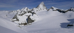
La Fouly is a mountain village in the Val Ferret. It is an important stop on the Haute Route from Chamonix to Zermatt, especially on the so-called Grande Lui variant over the Col du Grand Lui and further from La Fouly to the Grand-Saint-Bernard Pass. From La Fouly, you can also set out on ski tours to Mont Dolent and the summit of Grand Lui. There are several accommodation options, especially in the mountain lodge Gite d’Étape.
Tours starting from hut
Ski tours around Hut La Fouly

- Country
- Switzerland
- Montains
- Walliser Alpen / Alpes valaisannes
- Open (winter)
- December - mid April
- Beds
- 17
- Winterraum
- no
- Shortening of access (cableway, lift, taxi, snowcat...)
- accessible by car
- Card Pay
- yes
- Shower
- yes
- Wifi
- yes
- UTM / CH1903 x ("longitude" E/W)
- 573627
- UTM / CH1903 y ("latitude" N/S)
- 86901
- GPX all tours from the hut
- LaFouly_ALL_skitours.gpx
- Map
- Martigny 282 S, Swisstopo 1:50000 1365 Gd-St-Bernard, Swisstopo 1:25000 1345 Orsières, Swisstopo 1:25000
- Guides
- Ski de randonnée Bas-Valais Die klassischen Skitouren (SAC, deutsch) Les classiques de randonnée à ski (SAC, francais) Walliser Alpen (Rother, deutsch) Haute Route (Rother, deutsch) Haute Route Chamonix-Zermatt (JM editions, french)
- Phone (hut)
- +41 275650653
- Phone (valley)
- -
- Cell phone
- +41792933713
- Mobile Signal
- yes
- Web
- gitedelafouly.ch
- info@gitedelafouly.ch
- Owner of hut
- privat
- Avalanche danger
- www.slf.ch
- Weather
- La Fouly 1600 m / meteoblue.com Mont Dolent 3823 m / meteoblue.com Grande Lui 3509 m / meteoblue.com Mont Dolent 3823 m / mountain-forecast.com Grande Lui 3509 m / mountain-forecast.com SRF.ch SRF.ch - La Fouly Meteoschweiz
- Snow report
- Val Ferret - La Fouly, bergfex.ch Val Ferret - La Fouly, snow-forecast.com Val Ferret - La Fouly, onthesnow.com
- Webcams
- Tunnel Gd St Bernard Pays St. Bernard
- Region
- La Fouly Pays St. Bernard Wallis.ch
- Public traffic
- train SBB Bus - Postauto.ch
- Skiresort nearby
- Val Ferret - La Fouly Verbier
- Other links
- Swiss Tourism
hut La Fouly - Reviews
There are no reviews in this section yet. Click the Add Review button to add first review.
Best ski tours in mountains Walliser Alpen / Alpes valaisannes, Switzerland
-

Tour du Ciel - day 5 3030 m
Turtmannhütte / Cabane Tourtemagne Walliser Alpen / Alpes valaisannes Switzerland
- Length of ascent5,5 km
- ascent1110 m
- duration5-7 h
- Fitness difficulty ♦♦◊◊
- Technical difficulty ♦♦◊◊
A relatively easy ascent, though steep in places, from Lake Turtmannsee, which is reached by descending from the Turtmannhütte. From the summit ridge, there's a long descent to the Hotel Weisshorn, followed by forest trails leading down to the village of St. Luc - Chandolin in the Val d'Anniviers.

-

Tour du Ciel - day 2 3404 m
Schönbielhütte Walliser Alpen / Alpes valaisannes Switzerland
- Length of ascent5 km
- ascent1190 m
- duration5-7 h
- Fitness difficulty ♦♦♦◊
- Technical difficulty ♦♦♦◊
Tour du Ciel (known as the reverse direction of the Haute Route Impériale) begins with the first real stage from the Schönbiel Hut, featuring a descent along the edge of the moraine. This is followed by a long, steep climb over glacier seracs, ideally tackled in the early morning. The subsequent ascent over the Hohlwäng Glacier to the Col Durand (3404 m) is then straightforward. An alternative is to turn right before the pass and climb Mont Durand. From the pass, descend over the Glacier Durand, followed by a short climb to the Cabane Mountet.
-

Breithorn - Zermatt 4164 m
Monte Rosa Hütte Walliser Alpen / Alpes valaisannes Switzerland
- Length of ascent3 km
- ascent440 m
- duration3-4 h
- Fitness difficulty ♦♦♦◊
- Technical difficulty ♦♦♦◊
Breithorn can be rated as the lightest 4000 in the Alps. In any case, thanks to the support of the Klein Matterhorn cable car, which transports ski mountaineers up to 3880 m. From the cable car station (beautiful viewpoint) to the glacier plain below the summit, which can be often reached on skis. In good conditions, it is worthwhile to continue to the Schwarztor saddle and drive descent back to Zermatt. The second variant of the freeride is the descent from the Unterer Theodulgletscher. This descent is simply great up to Seehöre 2400.
Best ski tours in Switzerland by skitour.guru
-

Jungfrau 4158 m
Konkordiahütte Berner Alpen / Alpes bernoises Switzerland
- Length of ascent10 km
- ascent1510 m
- duration6,5-9 h
- Fitness difficulty ♦♦♦◊
- Technical difficulty ♦♦♦◊
Skialpová túra na Jungfrau z chaty Konkordia začíná velmi dlouhým nástupem po ledovci Jungfraufirn. Následuje prudký výstup na hřeben a dále do sedla Rottalsattel přes nepříjemnou thlinu. Skidepot a na mčkách a s cepínem po plochém hřebenu na vrchol. Alternativní sjezd přes sedlo Louwitor na ledovec Aletschfirn a po něm na chatu Konkordia. Možné je po dosažení vrcholu pokračovat na nádraží Jungfraujoch nebo nocovat na Mönchsjochhütte.
-

Cima di Rosso 3365 m
Fornohütte - Capanna del Forno Bernina Alps Switzerland
- Length of ascent7,5 km
- ascent1255 m
- duration4,5-6 h
- Fitness difficulty ♦♦♦◊
- Technical difficulty ♦♦♦◊
Cima di Rosso je skialpová klasika v oblasti Forno. Ledovcová túra s vynikajícim výhledem na Munt Disgrazia a Piz Bernina. Kromě sjezdu po trase výstupu je možná sjezdová alernativa severním svahem, kde bývá často prašan.
-
Vorderes Galmihorn 3507 m
Oberaarjochhütte Berner Alpen / Alpes bernoises Switzerland
- Length of ascent2,5 km
- ascent760 m
- duration4,5-6,5 h
- Fitness difficulty ♦♦◊◊
- Technical difficulty ♦♦♦◊
Vorderes Galmihorn je skvělý skialpový vrchol na závěr akce v centru Bernských Alp. Po výstupu na vrchol z chaty Oberaletschhütte přináší skvělou možnost sjezdu do údolí Goms, což je logisticky výhodné v případě startu lanovkou z Fiesch. Výstup vede po mírném ledovci Galmigletscher a dále po přehledném svahu posetém trhlinami. Při sjezdu dávejte pozor na trhlinu pod sedlem Bächlilicke. Na jaře vás v závěru túry nemine pochod do údolí s lyžemi na batohu. Nabízí se sjezd do Reckingenu nebo Münsteru.