
 Česky
Česky Deutsch


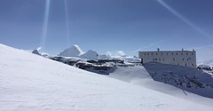


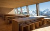

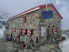

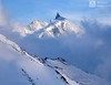
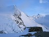


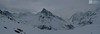


Cabane Tracuit was converted to a brand new high-tech hut in 2013. Tracuit hut is located on the Haute Route Imperiale (french Tour du Ciel). Starting point for the climb to 4000 Bishorn. It is possible to go to the Turtmannhütte, in good conditions you can do this above the Üssers Barrhorn. Zinal's access is very long. In order to master the route from Cabane Mountet to Blanc Moming, is excellent physical condition required.
Tours starting from hut
Ski tours around Hut Cabane Tracuit
-

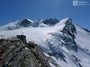
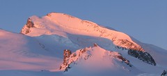
Bishorn 4153 m
Cabane Tracuit Walliser Alpen / Alpes valaisannes Switzerland
- Length of ascent4,5 km
- ascent950 m
- duration5-6,5 h
- Fitness difficulty ♦♦♦◊
- Technical difficulty ♦♦◊◊
Bishorn seems to be a relatively light 4000, but looks are deceptive. If you include the approach to Cabane Tracuit from Zinal in the ascent, it is quite a long ski tour. From the hut the ascent line leads slightly up the glacier Turtmanngletscher. Directly below the peak on the plateau you have to swap skis for crampons and comfortably climb to the panoramic summit - one of the best in all of Valais. Driving down the northern slope is usually a fantastic enjoyment, the risk of glacier cracks is minimal.

-

Tour du Ciel - day 4 4153 m
Cabane Tracuit Walliser Alpen / Alpes valaisannes Switzerland
- Length of ascent6 km
- ascent1150 m
- duration5,5-7,5 h
- Fitness difficulty ♦♦♦◊
- Technical difficulty ♦♦♦◊
The stage begins at the Cabane Tracuit with an ascent of the 4,000-meter peak Bishorn, which is considered relatively easy. After skiing back down to the Tracuit hut, the route continues with a descent over the Turtmanngletscher glacier. A subsequent climb over the Brunegggletscher glacier leads into a rocky corridor, which marks the beginning of the descent to the Turtmannhütte.
- Country
- Switzerland
- Montains
- Walliser Alpen / Alpes valaisannes
- Open (winter)
- mid March - mid May
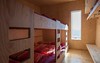
- Beds
- 115
- Winterraum
- yes, 30 beds
- Shortening of access (cableway, lift, taxi, snowcat...)
- no
- Luggage transport
- no
- Card Pay
- no
- Shower
- no
- Wifi
- no
- UTM / CH1903 x ("longitude" E/W)
- 618620
- UTM / CH1903 y ("latitude" N/S)
- 108770
- GPX access to hut (waipoints, track)
- Tracuit-Hut_access_Zinal.gpx
- GPX access to hut (track only)
- Tracuit-Hut_access_Zinal_TRK.gpx
- Map
- Arolla 283 S, Swisstopo 1:50000 Montana 273 S, Swisstopo 1:50000 Evolene 1327, Swisstopo 1:25000 Vissoie 1307, Swisstopo 1:25000 St. Niklaus 1308, Swisstopo 1:25000
- Guides
- Ski de randonnée Bas-Valais Die klassischen Skitouren (SAC, deutsch) Les classiques de randonnée à ski (SAC, francais) Walliser Alpen (Rother, deutsch)
- find current conditions and experiences on the spot
- gipfelbuch.ch
- Phone (hut)
- +41 27 475 15 00
- Phone (valley)
- -
- Cell phone
- -
- Mobile Signal
- no
- Web
- tracuit.ch
- cabane@tracuit.ch
- Owner of hut
- CAS Chaussy
- Cabane Tracuit
- Reservation
- online former
- Online reservation
- tracuit.ch
- Start Point
- Zinal
- UTM / CH1903 x ("longitude" E/W)
- 614392
- UTM / CH1903 y ("latitude" N/S)
- 109620
- Altitude
- 1670 m
- Ascent (height difference)
- 1595 m
- Time of Access
- 6,5-7,5 h
- Shortening lift
- no
- Avalanche danger
- www.slf.ch
- Weather
- SRF Meteo Meteoschweiz Zinal, snow-forecast.com Cabane Tracuit, meteoblue.com Blanc Moming 3663 / mountain-forecast.com Les Diablons 3609 m / mountain-forecast.com Bishorn 4153 / mountain-forecast.com Üssers Barrhorn 3610, mountain-forecast.com Schweiz TV - animation Bergwetter / alpenverein.at Zinal, meteoblue.com
- Snow report
- Zinal, snow-forecast.com Zinal, bergfex.ch Zinal, onthesnow.com Zinal, skiresort.info snow.myswitzerland.com/
- Webcams
- Cabane Tracuit Zinal webcams
- Region
- Val d´Anniviers Wallis.ch
- Public traffic
- train SBB bus - Postauto.ch
- Skiresort nearby
- Grimentz-Zinal
- Other links
- Swiss Tourism
hut Cabane Tracuit - Reviews
stodulka 29. 06. 2025
- Staff ♦♦♦♦
- Food ♦♦♦♦
- Overnight room ♦♦♦◊
- Overnight lager ♦♦♦♦
- Cosiness ♦♦◊◊
- Overall rating ♦♦♦♦
- Comment Nádherný výhled prosklenou stěnou při západu slunce. Výchozí bod na Bishorn přes Trutmanngletscher, na kterém jsme ale viděli záchranářskou akci po pádu do trhliny.
Best ski tours in mountains Walliser Alpen / Alpes valaisannes, Switzerland
-
Strahlhorn 4190 m
Britannia Hütte Walliser Alpen / Alpes valaisannes Switzerland
- Length of ascent9,4 km
- ascent1250 m
- duration6-8 h
- Fitness difficulty ♦♦♦◊
- Technical difficulty ♦♦◊◊
Strahlhorn (Britannia Hütte, Walliser Alpen) is a classic glacier ski tour from Britannia Hütte. From the Adlerpass saddle, you usually go skiing to the top. To get off Saas Fee, take the Metro to the "window" at 3460 m to the Hohlaub Gletscher and start the ascent after a short ride.
-

Tour du Ciel - day 3 3649 m
Cabane du Mountet Walliser Alpen / Alpes valaisannes Switzerland
- Length of ascent10,5 km
- ascent2420 m
- duration10-12 h
- Fitness difficulty ♦♦♦♦
- Technical difficulty ♦♦♦♦
A very long and demanding, royal stage of this Haute Route. In my opinion, the most impressive stage of all multi-day Alpine crossings. Due to the elevation gain and time required, it’s worth considering splitting the stage into two days with an overnight stay in Zinal. The long, exposed ridge to the summit requires rope protection depending on conditions. The descent is fantastically long, but caution is needed – there are large crevasses. This ski tour is only recommended in stable weather; in poor conditions, it’s advisable to bypass the Blanc de Moming via the Glacier de Zinal and ascend directly to the Cabane de Tracuit.
-

Blanc de Moming - Dôme Circuit 3649 m
Cabane du Mountet Walliser Alpen / Alpes valaisannes Switzerland
- Length of ascent10 km
- ascent2035 m
- duration9-11 h
- Fitness difficulty ♦♦♦♦
- Technical difficulty ♦♦♦♦
Blanc de Moming - Dôme is a beautiful but also very demanding complex ski tour. First ascent from Cabane Mountet to La Forcle saddle and then not very easy descent and then ascent along the Glacier du Besso. At the end of the glacier there is an uncomfortable border between snow and rock. Climb a rocky slope. First along a flat ridge, which is increasingly exposed. It is recommended to belay in windy weather. At the beginning of the spectacular descent along the Glacier de Moming, pay attention to the gigantic cracks. The departure line (keep left) turns from the northern to the western slope. After reaching the valley there is an easy ascent along the Glacier de Zinal back to Cabane Mountet.
Best ski tours in Switzerland by skitour.guru
-

Piz Kesch - Chamanna Kesch 3417 m
Keschhütte / Chamanna digl Kesch Albula Alps Switzerland
- Length of ascent4,5 km
- ascent845 m
- duration4,5-6 h
- Fitness difficulty ♦♦◊◊
- Technical difficulty ♦♦♦◊
Piz Kesch is a well-known mountain in the Albula Alps region, Piz Kesch clearly falls on the surrounding mountains. The view of Kesch can be enjoyed from Bernina, Muragl and other peaks. The ascent to the ski depot is easy. You go on / climb with an ice axe and crampons. The exposed terrain in places, the difficulty depends on the current snow conditions. Rope protection is usually not necessary. A perfect panoramic view from above.
-

Vordere/ Hintere Jamspitze SW 3155 m
Tuoi Chamonna / Tuoihütte Silvretta Switzerland
- Length of ascent km
- ascent910 m
- duration3-4 h
- Fitness difficulty ♦♦◊◊
- Technical difficulty ♦♦◊◊
-

Hubelhorn (day 4, h.r. Swiss Glacier) 3244 m
Bächlitalhütte Berner Alpen / Alpes bernoises Switzerland
- Length of ascent11,5 km
- ascent1730 m
- duration9-11 h
- Fitness difficulty ♦♦♦◊
- Technical difficulty ♦♦♦◊
The Hubelhorn skitour is an ideal extension of the crossing between the Bächlitalhütte and Gaulihütte. After a short ride from the saddle, Obri Bächlilicke climbs through the steep east slope into the rocky saddle and then slightly up the crossing to Hubelhorn. Beware of some hot spots at the Gauligletscher Glacier. From Gauli hut is a nice tour through the northern slope, but in the opposite direction.