
 Česky
Česky Deutsch


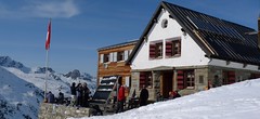


The Chalet Turtmannhütte, french Cabane Tourtemagne, is in a relatively secluded location. Magnificent backdrop of the nearby rock walls and glaciers. The mountain hut is famous for its home cooking, especially excellent soups. The Turtmannhütte is the last hut on the Haute Route Imperale / Tour du Ciel. Üssers Barrhorn is an attractive ski tour. The last tour of the crossing is the ascent to the l´Omen Roso and a spectacular descent to the village of St-Luc. The best way to the hut is by cable car from the Anniviers valley. From the St-Luc ski resort take the cable car at 3000m to Bella Tola and from there via Borterpass and Meidtälli to the hut.
Tours starting from hut
Ski tours around Hut Turtmannhütte / Cabane Tourtemagne
-

Tour du Ciel - day 5 3030 m
Turtmannhütte / Cabane Tourtemagne Walliser Alpen / Alpes valaisannes Switzerland
- Length of ascent5,5 km
- ascent1110 m
- duration5-7 h
- Fitness difficulty ♦♦◊◊
- Technical difficulty ♦♦◊◊
A relatively easy ascent, though steep in places, from Lake Turtmannsee, which is reached by descending from the Turtmannhütte. From the summit ridge, there's a long descent to the Hotel Weisshorn, followed by forest trails leading down to the village of St. Luc - Chandolin in the Val d'Anniviers.

-
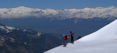
L´Omen Roso 3030 m
Turtmannhütte / Cabane Tourtemagne Walliser Alpen / Alpes valaisannes Switzerland
- Length of ascent6 km
- ascent1300 m
- duration5,5-7 h
- Fitness difficulty ♦♦◊◊
- Technical difficulty ♦♦◊◊
L´Omen Roso is a relatively easy to reach 3000 peak on the edge of the Valais Alps. The ascent begins either in the Turtmannhütte or in the St. Luc ski area in Val d´Anniviers. The usual is this ski tour last stage of the Haute Route Tour du Ciel. From the hut up to the crest and the descent on the other side, into the valley. A technically undemanding ski tour. On the upper ridge, watch out for the cornices.
- Country
- Switzerland
- Montains
- Walliser Alpen / Alpes valaisannes
- Open (winter)
- end March - mid May
- Beds
- 74
- Winterraum
- yes, 14 beds
- Shortening of access (cableway, lift, taxi, snowcat...)
- no
- Luggage transport
- no
- Card Pay
- no
- Shower
- no
- Wifi
- no
- UTM / CH1903 x ("longitude" E/W)
- 620160
- UTM / CH1903 y ("latitude" N/S)
- 112100
- GPX access to hut (waipoints, track)
- TurtmannHut_access_skitour.gpx
- GPX access to hut (track only)
- TurtmannHte_access_StLuc_BellaTolaTRK.gpx
- Map
- Visp 274 S, Swisstopo 1:50000 Montana 273 S, Swisstopo 1:50000 Evolene 1287, Swisstopo 1:25000 Vissoie 1307, Swisstopo 1:25000 St. Niklaus 1308, Swisstopo 1:25000 Raron 1288, Swisstopo 1:25000
- Guides
- Ski de randonnée Bas-Valais Die klassischen Skitouren (SAC, deutsch) Les classiques de randonnée à ski (SAC, francais) Walliser Alpen (Rother, deutsch)
- find current conditions and experiences on the spot
- gipfelbuch.ch
- Phone (hut)
- +41 27 932 14 55
- Phone (valley)
- +41 27 934 34 84
- Cell phone
- -
- Mobile Signal
- no
- Web
- turtmannhuette.ch
- info@turtmannhuette.ch
- Owner of hut
- CAS Prevotoise
- SAC Turtmannhütte
- Reservation
- e-mail, phone
- Start Point
- St-Luc, cable car station Bella Tolla
- UTM / CH1903 x ("longitude" E/W)
- 616662
- UTM / CH1903 y ("latitude" N/S)
- 120813
- Altitude
- 3026 m
- Ascent (height difference)
- 950 m
- Time of Access
- 4-5 h
- Shortening lift
- yes, from St-Luc to Bella Tola
- Avalanche danger
- www.slf.ch
- Weather
- SRF Meteo Meteoschweiz St.Luc - Chandolin, snow-forecast.com Brunegghorn /mountain-forecast.com Omen Roso / mountain-forecast.com Les Diablons 3609 m / mountain-forecast.com Bishorn 4153 / mountain-forecast.com Üssers Barrhorn 3610, mountain-forecast.com Schweiz TV - animation Bergwetter / alpenverein.at St.Luc - Chandolin / meteoblue.com Turtmanntal / yr.no
- Snow report
- St.Luc - Chandolin, snow-forecast.com St.Luc - Chandolin, bergfex.ch St.Luc - Chandolin, onthesnow.com St.Luc - Chandolin, skiresort.info snow.myswitzerland.com/
- Webcams
- St. Luc - Chandolin, 5 webcams Zinal webcams
- Region
- Turtmanntal Tourismus Wallis.ch Val d´Anniviers
- Public traffic
- train SBB bus - Postauto.ch
- Skiresort nearby
- St. Luc - Chandolin
- Other links
- Swiss Tourism
hut Turtmannhütte / Cabane Tourtemagne - Reviews
There are no reviews in this section yet. Click the Add Review button to add first review.
Best ski tours in mountains Walliser Alpen / Alpes valaisannes, Switzerland
-

Tour du Ciel - day 4 4153 m
Cabane Tracuit Walliser Alpen / Alpes valaisannes Switzerland
- Length of ascent6 km
- ascent1150 m
- duration5,5-7,5 h
- Fitness difficulty ♦♦♦◊
- Technical difficulty ♦♦♦◊
The stage begins at the Cabane Tracuit with an ascent of the 4,000-meter peak Bishorn, which is considered relatively easy. After skiing back down to the Tracuit hut, the route continues with a descent over the Turtmanngletscher glacier. A subsequent climb over the Brunegggletscher glacier leads into a rocky corridor, which marks the beginning of the descent to the Turtmannhütte.
-

Pigne d´Arolla 3790 m
Cabane des Dix Walliser Alpen / Alpes valaisannes Switzerland
- Length of ascent6 km
- ascent1000 m
- duration5-7,5 h
- Fitness difficulty ♦♦◊◊
- Technical difficulty ♦♦♦◊
Pigne d´Arolla is a very popular and easily accessible viewpoint. The ski tour to the summit leads from the three mountain huts - Cabane Dix, Cabane Vignettes and Cabane Chanrion. The route from Dix goes around the glacial seracs to the saddle Col de la Serpentine and the summit can be reached on skis. A worthwhile summit on the Haute Routes to Zermatt.
-

Tour du Ciel - day 3 3649 m
Cabane du Mountet Walliser Alpen / Alpes valaisannes Switzerland
- Length of ascent10,5 km
- ascent2420 m
- duration10-12 h
- Fitness difficulty ♦♦♦♦
- Technical difficulty ♦♦♦♦
A very long and demanding, royal stage of this Haute Route. In my opinion, the most impressive stage of all multi-day Alpine crossings. Due to the elevation gain and time required, it’s worth considering splitting the stage into two days with an overnight stay in Zinal. The long, exposed ridge to the summit requires rope protection depending on conditions. The descent is fantastically long, but caution is needed – there are large crevasses. This ski tour is only recommended in stable weather; in poor conditions, it’s advisable to bypass the Blanc de Moming via the Glacier de Zinal and ascend directly to the Cabane de Tracuit.
Best ski tours in Switzerland by skitour.guru
-
Finsteraarhorn 4374 m
Finsteraarhornhütte Berner Alpen / Alpes bernoises Switzerland
- Length of ascent3,5 km
- ascent1280 m
- duration7-9,5 h
- Fitness difficulty ♦♦♦◊
- Technical difficulty ♦♦♦♦
Na vrchol Finsteraarhorn míří náročná ledovcová túra z chaty Finsteraarhornhütte. Hned od začátku túry jsou cestou velkolepé výhledy. Náročnější je překonání skalního žebra. Po ledovci do sedla Hugisattel s leteckým pohledem na východní stěnu. Zde je skidepot a dál v mačkách a s cepínem na skialpové poměry náročným terénem. Obtížnost lezení zásadně ovlivňuje množství a konzistence sněhu na skále. Náročný sjezd prudkými svahy kopíruje linii výstupu.
-

Piz Buin SE (Tuoihütte) 3312 m
Tuoi Chamonna / Tuoihütte Silvretta Switzerland
- Length of ascent5,5 km
- ascent1170 m
- duration5,5-7 h
- Fitness difficulty ♦♦♦◊
- Technical difficulty ♦♦♦◊
Piz Buin ze švýcarské strany je zajímavější túra než ze strany rakouské. výstup v závěrečné části je stejný. Pod stěnu vede trasa přes sedla Plan Mezdi a Fuorcla dal Cunfin. Za stabilní sněhové pokrývky je alternativou sjezd žlabem Buinlücke.
-
Vorderes Galmihorn 3507 m
Oberaarjochhütte Berner Alpen / Alpes bernoises Switzerland
- Length of ascent2,5 km
- ascent760 m
- duration4,5-6,5 h
- Fitness difficulty ♦♦◊◊
- Technical difficulty ♦♦♦◊
Vorderes Galmihorn je skvělý skialpový vrchol na závěr akce v centru Bernských Alp. Po výstupu na vrchol z chaty Oberaletschhütte přináší skvělou možnost sjezdu do údolí Goms, což je logisticky výhodné v případě startu lanovkou z Fiesch. Výstup vede po mírném ledovci Galmigletscher a dále po přehledném svahu posetém trhlinami. Při sjezdu dávejte pozor na trhlinu pod sedlem Bächlilicke. Na jaře vás v závěru túry nemine pochod do údolí s lyžemi na batohu. Nabízí se sjezd do Reckingenu nebo Münsteru.