
 Česky
Česky Deutsch


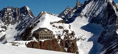


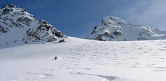
The Cabane des Vignettes is located at the crossroads of two haute routes to Zermatt. One leads from Chamonix and the other from Verbier. All ski tours to the Vignettes hut follow the glaciers. The easiest approach is from Arolla. In addition to going from hut to hut, you can ski from Vignettes to the peaks of L'Eveque, Mont Brulé and Pigne Arolla. Reservations have to be made on time.
Tours starting from hut
Ski tours around Hut Cabane des Vignettes

- Country
- Switzerland
- Montains
- Walliser Alpen / Alpes valaisannes
- Open (winter)
- mid March - end May
- Beds
- 120
- Winterraum
- yes, 12 beds
- Shortening of access (cableway, lift, taxi, snowcat...)
- no
- Luggage transport
- no
- Card Pay
- yes
- Shower
- no
- Wifi
- no
- UTM / CH1903 x ("longitude" E/W)
- 602870
- UTM / CH1903 y ("latitude" N/S)
- 93140
- GPX access to hut (waipoints, track)
- VignettesH_access_Arolla.gpx
- GPX access to hut (track only)
- Vignettes-Hut_all_access_TRK.gpx
- Map
- Arolla 283 S, Swisstopo 1:50000 Matterhorn 1347, Swisstopo 1:25000
- Guides
- Ski de randonnée Bas-Valais Die klassischen Skitouren (SAC, deutsch) Les classiques de randonnée à ski (SAC, francais) Walliser Alpen (Rother, deutsch)
- Phone (hut)
- +41 27 283 13 22
- Phone (valley)
- -
- Cell phone
- -
- Mobile Signal
- yes
- Web
- cabanedesvignettes.ch
- info@cabanedesvignettes.ch
- Owner of hut
- SAC Monte Rosa
- Cabane des Vignettes
- Reservation
- online former
- Online reservation
- alpsonline.org
- Avalanche danger
- www.slf.ch
- Weather
- SRF Meteo Meteoschweiz Cabane Vignettes. meteoblue.com Mont Collon, mountain-forecast.com Pigne Arolla, mountain-forecast.com L´Eveque, mountain-forecast.com Arolla, yr.no Arolla, snow-forecast.com
- Snow report
- Arolla, snow-forecast.com Arolla, bergfex.ch Arolla, onthesnow.com skiresort.info snow.myswitzerland.com/
- Webcams
- Evolene Arolla
- Region
- Val d´Hérens Wallis.ch
- Public traffic
- train SBB bus - Postauto.ch
- Skiresort nearby
- Arolla Verbier
- Other links
- Swiss Tourism
hut Cabane des Vignettes - Reviews
There are no reviews in this section yet. Click the Add Review button to add first review.
Best ski tours in mountains Walliser Alpen / Alpes valaisannes, Switzerland
-

Tour du Ciel - day 4 4153 m
Cabane Tracuit Walliser Alpen / Alpes valaisannes Switzerland
- Length of ascent6 km
- ascent1150 m
- duration5,5-7,5 h
- Fitness difficulty ♦♦♦◊
- Technical difficulty ♦♦♦◊
The stage begins at the Cabane Tracuit with an ascent of the 4,000-meter peak Bishorn, which is considered relatively easy. After skiing back down to the Tracuit hut, the route continues with a descent over the Turtmanngletscher glacier. A subsequent climb over the Brunegggletscher glacier leads into a rocky corridor, which marks the beginning of the descent to the Turtmannhütte.

-

Pigne d´Arolla 3790 m
Cabane des Dix Walliser Alpen / Alpes valaisannes Switzerland
- Length of ascent6 km
- ascent1000 m
- duration5-7,5 h
- Fitness difficulty ♦♦◊◊
- Technical difficulty ♦♦♦◊
Pigne d´Arolla is a very popular and easily accessible viewpoint. The ski tour to the summit leads from the three mountain huts - Cabane Dix, Cabane Vignettes and Cabane Chanrion. The route from Dix goes around the glacial seracs to the saddle Col de la Serpentine and the summit can be reached on skis. A worthwhile summit on the Haute Routes to Zermatt.
-

Blanc de Moming - Dôme Circuit 3649 m
Cabane du Mountet Walliser Alpen / Alpes valaisannes Switzerland
- Length of ascent10 km
- ascent2035 m
- duration9-11 h
- Fitness difficulty ♦♦♦♦
- Technical difficulty ♦♦♦♦
Blanc de Moming - Dôme is a beautiful but also very demanding complex ski tour. First ascent from Cabane Mountet to La Forcle saddle and then not very easy descent and then ascent along the Glacier du Besso. At the end of the glacier there is an uncomfortable border between snow and rock. Climb a rocky slope. First along a flat ridge, which is increasingly exposed. It is recommended to belay in windy weather. At the beginning of the spectacular descent along the Glacier de Moming, pay attention to the gigantic cracks. The departure line (keep left) turns from the northern to the western slope. After reaching the valley there is an easy ascent along the Glacier de Zinal back to Cabane Mountet.
Best ski tours in Switzerland by skitour.guru
-

Cima di Rosso 3365 m
Fornohütte - Capanna del Forno Bernina Alps Switzerland
- Length of ascent7,5 km
- ascent1255 m
- duration4,5-6 h
- Fitness difficulty ♦♦♦◊
- Technical difficulty ♦♦♦◊
Cima di Rosso je skialpová klasika v oblasti Forno. Ledovcová túra s vynikajícim výhledem na Munt Disgrazia a Piz Bernina. Kromě sjezdu po trase výstupu je možná sjezdová alernativa severním svahem, kde bývá často prašan.
-
Flüela Wisshorn 3085 m
Davos Albula Alps Switzerland
- Length of ascent6,5 km
- ascent1360 m
- duration5,5-7 h
- Fitness difficulty ♦♦◊◊
- Technical difficulty ♦♦♦◊
Flüela Wisshorn is the most interesting ski tour around Davos. It is offered to do an interesting round with two great downhills. The north slope to the Jöriseen lakes promises powder, while the south slopes to the Flüelatal valley promise firn. The ascent is not very demanding, at the end to the summit without skis with the help of crampons, then down to Jöriseen and noc once in the nameless saddle. Finally departure to the Flüelatal. Attention, in 2019 there was a landslide of stones in the area of the ascent route, which therefore changes the ascent route.
-

Chli Bielenhorn 2940 m
Andermatt - Realp - Oberalppass Urner Alps Switzerland
- Length of ascent8,5 km
- ascent1450 m
- duration5-6,5 h
- Fitness difficulty ♦♦♦◊
- Technical difficulty ♦♦◊◊
Chli Bielenhorn je skalnatá špička v říši monumentálních žulových stěn divokých hor. Začátek kolem silnice na Furkapass pokračuje po pláni pod chatou Albert-Heim-Hütte. Pak přichází v sousedství pohled na ledovce monumentálního Dammastocku. V kulisách skal vede logická linie ke skidepu kousek pod vrcholem. V případě stabilního sněhu je fajn alternativou sjezdová linie jižně od výstupové stopy a dále členitým terénem k hotelu Tiefenbach a v okolí silnice nebo po ní zpět do Realpu.